
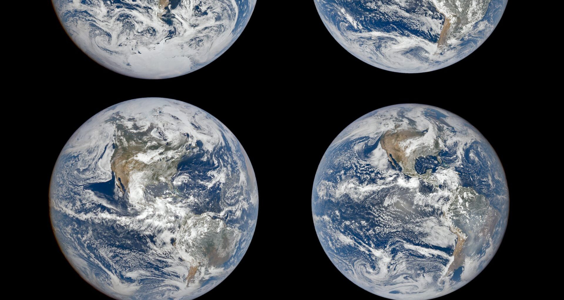
NASA images taken from nearly a million miles away reveal how Earth’s appearance shifts dramatically with the changing seasons.
Today’s Image of the Day from NASA Earth Observatory captures the remarkable seasonal shifts that are visible across our planet from space.
From the ground, the changing seasons arrive through familiar signs.
Shadows stretch or shrink. Snow retreats. Leaves appear, change color, and disappear. Daylight itself seems to expand and contract.
Seen from nearly a million miles away, the same annual cycle becomes something much bigger.
A series of images from NASA’s Earth Polychromatic Imaging Camera (EPIC) captures Earth around the two solstices and two equinoxes.
Together, the views reveal a planet that seems to shift dramatically over the course of a year.
Continents slide toward the center of the globe and then away again.
Antarctica emerges prominently in one season and disappears in another. Even Earth’s apparent size and shape change slightly.
A tilted planet
The main reason for these transformations is Earth’s axial tilt.
Our planet spins around an imaginary axis tilted about 23.5 degrees relative to the plane of its orbit around the Sun.
Scientists generally think that tilt is connected to the enormous collision early in Earth’s history that also led to the formation of the Moon.
Earth keeps roughly the same orientation as it travels around the Sun. As a result, each hemisphere spends part of the year tilted toward the Sun and another part tilted away.
During the June solstice, the Northern Hemisphere points more directly toward the Sun. Sunlight strikes it at a higher angle, and days become longer.
Six months later, around the December solstice, the Southern Hemisphere receives the advantage.
This changing geometry – rather than Earth’s distance from the Sun – produces the seasons.
Earth at the equinoxes
Between those extremes come the March and September equinoxes.
At an equinox, neither hemisphere is tilted strongly toward or away from the Sun.
The boundary separating Earth’s illuminated and dark halves, known as the terminator, passes through both poles.
Day and night consequently approach the same length across much of the planet.
The effect can be difficult to appreciate from Earth’s surface. EPIC offers a radically different perspective.
The camera flies aboard the Deep Space Climate Observatory (DSCOVR), positioned roughly one million miles from Earth near the Sun-Earth L1 Lagrange point.
From there, EPIC keeps watch over nearly the entire sunlit face of our planet.
Continents seem to shift
Four EPIC images taken at approximately the same time of day show the seasonal transformation particularly clearly.
During the December solstice, South America sits prominently near the middle of Earth’s disk.
Antarctica is clearly visible along the bottom, while much of North America extends beyond the camera’s view.
By the June solstice, the arrangement looks almost reversed.
North America moves closer to the center of the visible disk, and Arctic sea ice appears near the top. South America shifts downward, while Antarctica vanishes completely from sight.
The continents haven’t actually changed position relative to one another.
Instead, Earth’s tilt changes which parts of the globe face most directly toward the distant spacecraft.
Why Earth changes size
Look carefully and another difference emerges: Earth appears slightly smaller in the equinox images.
That effect has a different explanation.
DSCOVR does not remain at one fixed distance from Earth. The spacecraft travels along a looping three-dimensional path called a Lissajous orbit around the L1 region.
Its distance from Earth therefore changes continually.
For example, DSCOVR was about 899,000 miles from Earth on December 21, 2023. By September 22, 2024, the distance had increased to roughly 971,000 miles.
That difference is enough to subtly change Earth’s apparent diameter in EPIC’s images.
Earth isn’t always full
The spacecraft’s unusual orbit produces another visual effect.
The angle formed by the Sun, Earth, and DSCOVR varies as the spacecraft moves.
Sometimes EPIC sees an almost completely illuminated Earth. At other times, a small portion of the planet’s edge falls into darkness.
The result resembles the gibbous phase of the Moon, as though a thin bite has been removed from Earth’s disk.
Alexander Marshak, deputy project scientist for DSCOVR, noted that these orbital effects can be detected in the images. But they remain secondary to the much larger visual changes produced by Earth’s tilt.
A decade watching Earth
EPIC’s distant perspective does far more than provide striking pictures.
Because Earth rotates beneath the spacecraft, the instrument can capture the planet’s sunlit face every few hours.
After more than a decade in space, that repeated view has produced an unusual record of Earth’s daily and seasonal rhythms.
Researchers can follow clouds, vegetation, snow and ice, aerosols, ultraviolet radiation, and even changes in ocean color across the planet.
And the images turn one of the most familiar lessons in Earth science into something immediately visible.
Our planet’s seasons aren’t simply changes in weather. From deep space, they can be seen in the orientation of the entire world.
Image Credit: NASA Earth Observatory/Michala Garrison
—–
Like what you read? Subscribe to our newsletter for engaging articles, exclusive content, and the latest updates.
Check us out on EarthSnap, a free app brought to you by Eric Ralls and Earth.com.
—–