
Buffalo, N.Y. (WBEN) – As a massive nor’easter storm and blizzard churns its way to New England, the storm’s reach is close enough to have an impact on the Buffalo-Niagara region a remind us it is still winter.
“We’re going to see periods of light to moderate snow through tonight across Western New York,” National Weather Service meteorologist Heather Kenyon tells WBEN.
“Really we’re looking at minor accumulations, mainly 2 to 4 inches for most parts across Western New York,” Kenyon adds. “Some of the higher terrain could see up to 6 inches , and even localized, up to a foot across the Chautauqua Ridge.” Along the east-west NYS Thruway line, approximately 2 to 4 inches is forecast.
A Winter Storm Watch is posted for Chautauqua County, while a Winter Weather Advisory is posted for southern Erie, Wyoming and Cattaraugus counties through early Tuesday.
Periods of light snow will continue across western New York through tonight. Heavier snow is expected for areas south of Buffalo, where lake enhancement and upsloping will increase snowfall amounts. pic.twitter.com/wXss9UC7Br
— NWS Buffalo (@NWSBUFFALO) February 23, 2026
The snow will taper off Monday evening, and we get a break from snow during the day Tuesday, however temperatures Tuesday will struggle to get much above 20 degrees.
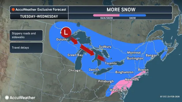
“Another round of widespread snow is going to move in Tuesday night through Wednesday,” Kenyon cautions. “So we could pick up a couple more inches.”
Is there a warmup in the forecast?
Maybe just a little, Kenyon tells WBEN.
“We are going to slowly warmup through the end of the week, however we’re not going to get out of the 30’s until possibly the weekend, but it does look like more rain and snow showers with that warmup.”
WINTER WEATHER ADVISORY REMAINS IN EFFECT UNTIL 6 AM EST TUESDAY
* WHAT…Snow. Total snow accumulations of 4 to 8 inches across the higher terrain of the Boston Hills, ridges of Wyoming County, and northern Cattaraugus County. Accumulations will be much lower in the valleys and lower elevations, where only 2 to 4 inches is expected.
* WHERE…Wyoming, Cattaraugus, and Southern Erie Counties. The greatest accumulations will be across higher terrain.
* WHEN…Until 6 AM EST Tuesday.
* IMPACTS…Travel will be difficult at times with snow covered roads and reduced visibility. The hazardous conditions will impact the Monday morning and evening commutes.
PRECAUTIONARY/PREPAREDNESS ACTIONS…
Periods of snow will result in snow covered roads and limited visibilities. Slow down and use caution while driving.
WINTER STORM WARNING REMAINS IN EFFECT UNTIL 6 AM EST TUESDAY
* WHAT…Heavy snow. Total snow accumulations 8 to 12 inches in a narrow band along the Chautauqua Ridge. Snow accumulations will be much lower along the Lake Erie shore and farther inland near Jamestown, where only 2 to 4 inches is expected.
* WHERE…Chautauqua County. The greatest accumulations will focus in a narrow band along the Chautauqua Ridge.
* WHEN…Until 6 AM EST Tuesday.
* IMPACTS…Travel will be difficult with snow covered roads and poor visibility at times. The hazardous conditions will impact the Monday morning and evening commutes.
PRECAUTIONARY/PREPAREDNESS ACTIONS…
Widespread accumulating snow will create difficult travel conditions.