
Satellite imagery of a remote village that once served as a Soviet supply port during the Cold War has revealed an odd discovery—one that resembles an iconic wintertime mainstay.
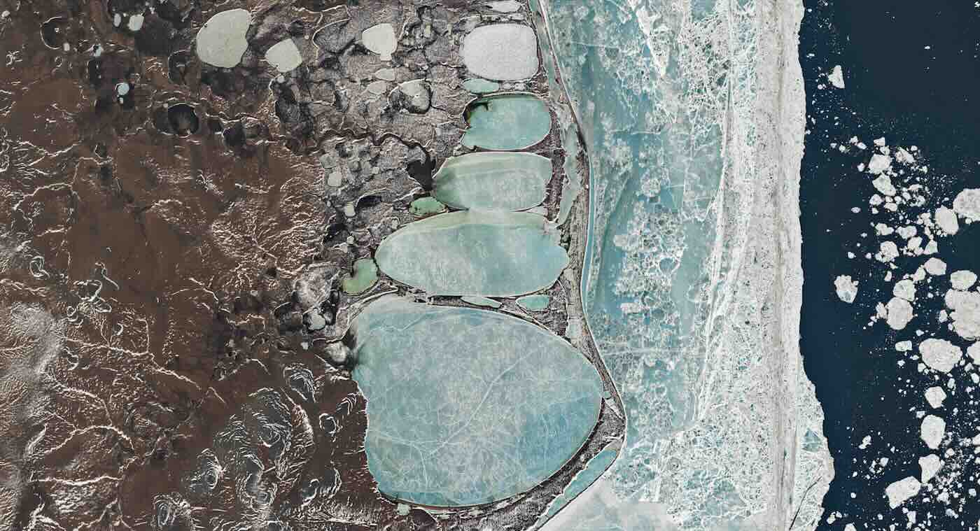
The images, obtained in June 2025 by the Landsat 8 satellite using its Operational Land Imager instrument, reveal a series of lagoons near Cape Billings on Russia’s Chukchi Peninsula. The orientation of these large lacustrine features causes them to resemble a stack of snowballs, in keeping with the frosty seasonal tradition of snowman-making.
“Though June is one of the warmest months in Billings, ice cover is routine even then,” read a statement issued by NASA to accompany the photos, which were featured as the space agency’s Image of the Day for December 17, 2025.
“Mean daily minimum temperatures are just minus 0.6 degrees Celsius (30.9 degrees Fahrenheit) in June, according to meteorological data,” the NASA statement read.
Landsat 8 has been operated by the United States Geological Survey (USGS) since 2013, and the agency continues to oversee its data collection and processing, imagery from which is often featured by its collaborators with NASA.
Siberian “Snowman” Lagoons: A Natural Feature
According to NASA, the “Siberian Snowman” lagoons in question are the result of soil that begins to slump during the summertime, which causes melting and, eventually, the formation of shallow depressions where meltwater collects.
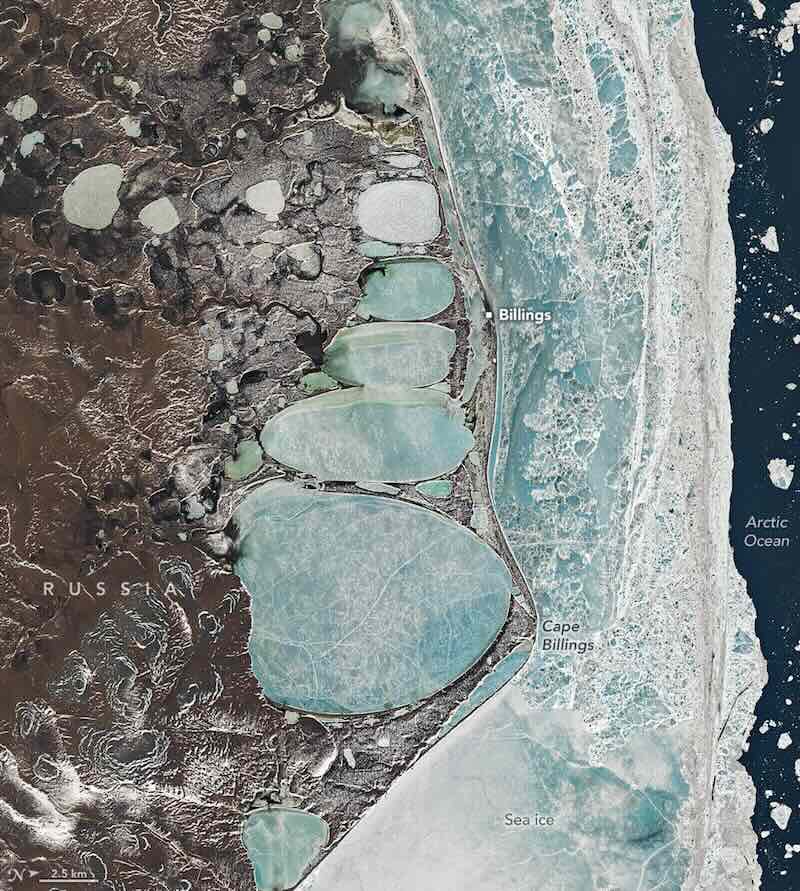 Landsat 8 image from June, 2025, revealing meltwater lagoons resembling a snowman in shape (Image Credit: USGS/NASA Earth Observatory).
These features, known as thermokarst lakes, are formed into their characteristic oval shapes by the action of wave movement across their surfaces, a process that is driven by winds, giving rise to their distinctive alignment and similar shape.
Odd Oval Lakes Around the World
Despite their unusual shape, these lagoons are natural formations, and are features that appear commonly in far northern regions, although similar features have been observed along the coastal southeastern United States.
Known as “Carolina Bays,” these similar formations in the American southeast have long been a subject of controversy, as some theories have argued them to be the result of ejecta that might have struck the landscape in the aftermath of a large-scale impact event long ago.
One popular idea put forward in recent years links such alleged impact features to a comet that may have struck the ice sheets that once covered much of North America at the end of the last Ice Age, with large chunks of glacial ice being removed and propelled as far south as the modern-day Carolinas. The ice that formed the resulting impact features would have melted, of course, leaving behind the large elliptical features that some today still regard as “craters.”
However, research conducted by Christopher Moore and colleagues in 2014 offered a strong argument that the Carolina Bays, much like their Siberian meltwater counterparts, “are oriented lakes that evolved over time through lacustrine and eolian processes.”
Siberian Lagoons
Along similar lines, NASA says that once these oval features begin to take shape in the Siberian summer months, “consistency in the direction of the winds and waves likely aligned and elongated the lakes into the shapes,” which can be readily seen in the recent Landsat 8 images.
“The thin ridges separating the lakes may represent the edges of different ice wedges below the surface,” NASA’s statement on the unique imagery added.
Additional details on the recent “Siberian Snowman” images, and other unique satellite imagery collected from vantages around the world, can be found at NASA’s Earth Observatory web page.
Micah Hanks is the Editor-in-Chief and Co-Founder of The Debrief. A longtime reporter on science, defense, and technology with a focus on space and astronomy, he can be reached at micah@thedebrief.org. Follow him on X @MicahHanks, and at micahhanks.com.