
Most people have watched a crack spread, on a phone screen, a windshield, or a sidewalk after a brutal winter. Now scale that up to Antarctica, where cracks can run for miles and the stakes are global.
Scientists tracking Thwaites Glacier in West Antarctica, commonly nicknamed the Doomsday Glacier, say a specific cracking process is helping a key part of it lose stability. In a new University of Manitoba-led analysis, researchers used two decades of satellite images and GPS measurements to track how fractures grew across the Thwaites Eastern Ice Shelf.
The short version is that the ice shelf has been gradually detaching from a pinning point, basically an underwater “speed bump” that helps hold it in place. As that grip weakens, the ice upstream can move faster toward the ocean. That is the kind of far-away change that eventually turns into very real headaches for coastal communities.
What exactly is the Thwaites Eastern Ice Shelf, and why does it matter?
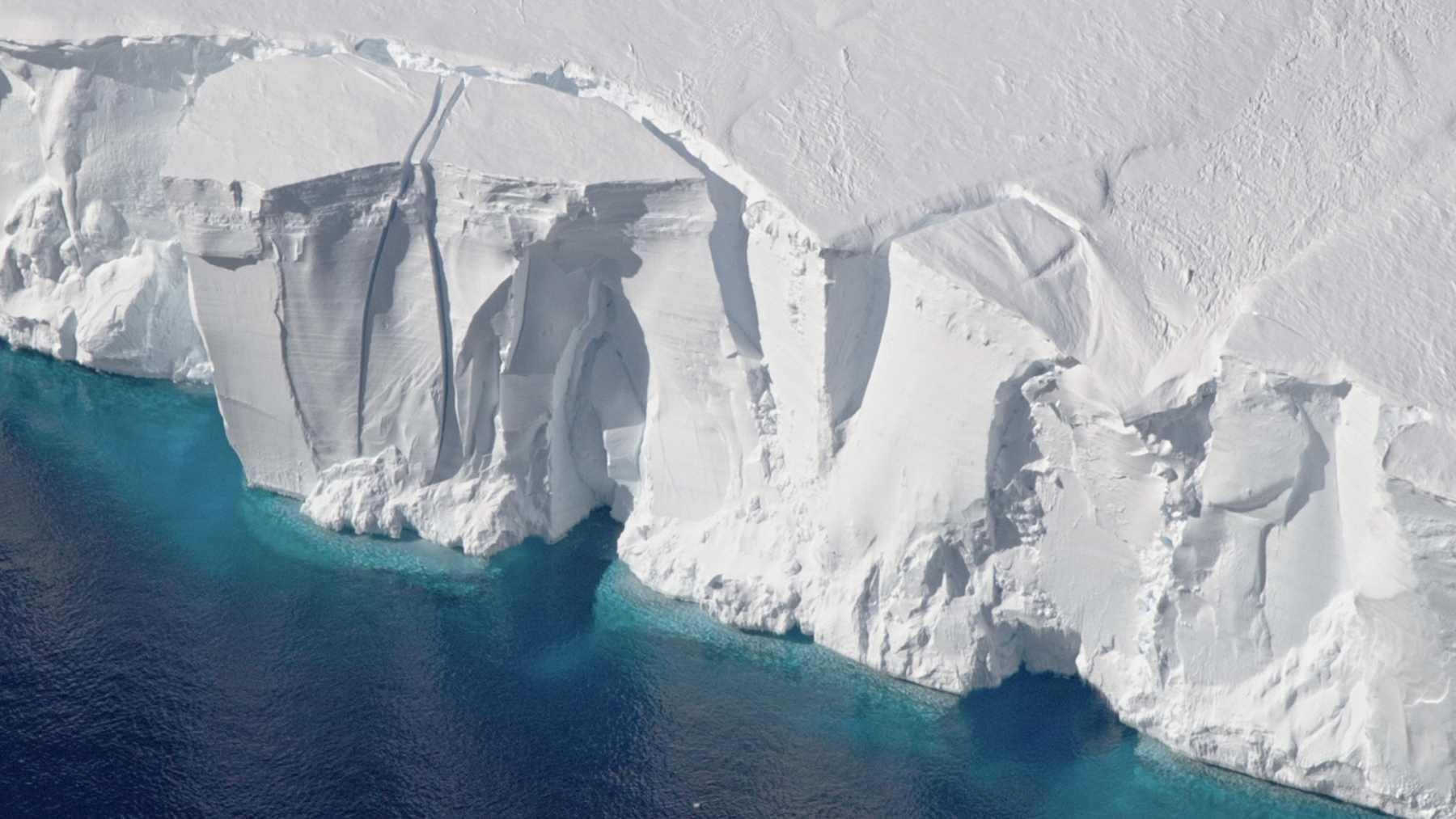
Thwaites Glacier sits in West Antarctica and flows toward the Amundsen Sea, where parts of it extend as floating ice. One of those floating extensions, the Thwaites Eastern Ice Shelf (often shortened to TEIS), is partially confined and anchored at its northern end by a pinning point.
Why should anyone outside Antarctica care? Because if Thwaites were to collapse entirely, it contains enough ice to raise global sea levels by about 65 centimeters, or roughly 25 inches. Floating shelves like TEIS also provide buttressing, meaning they act like a brace or brake that helps slow the land-based ice behind them. When that brace weakens, it can make it easier for more ice to flow into the ocean over time.
How can a pinning point turn into a problem instead of a stabilizer?
A pinning point is a grounded feature under the water, often a ridge, that a floating ice shelf presses against. Think of it like a doorstop: it can keep the door from swinging too far, until the door starts splintering around it.
The University of Manitoba team reports that shearing, meaning sideways grinding and stretching, around a prominent shear zone (a stressed strip of ice where movement concentrates and cracking becomes more likely) upstream of the pinning point has been central to TEIS’s progressive disintegration. In their account, the pinning point gradually shifted from being a stabilizing force to becoming part of the destabilization story as fractures accumulated and the shelf’s connection weakened.
What did satellite and GPS data from 2002 to 2022 actually show?
Researchers combined satellite imagery and ice-flow measurements, along with in-situ GPS records (on-the-ice sensors that track movement), to reconstruct how fractures evolved and how ice speed changed over time. They tracked three focus areas across TEIS: the shear zone near the pinning point, a mid-shelf region, and an area upstream of the pinning point. Their analysis also references the Thwaites Western Ice Tongue (TWIT), another floating section of the glacier.
Here’s how the thesis associated with the work breaks down the four stages of change over the 2002 to 2022 record.
Time periodStage described in the study materials2002–2006TWIT-driven acceleration phase2007–2012TEIS and TWIT shear-margin disintegration phase2012–2017TWIT disintegration phase2017–2022TEIS mid-shelf acceleration phase
Across those stages, the researchers describe fractures developing in two main phases: first, long fractures aligned with ice flow, followed later by shorter fractures oriented across the flow. This created a positive feedback loop: fracture damage and faster ice flow amplified each other, accelerating the shelf’s breakdown once key connections weakened.
What does this mean for sea-level rise, and what can people do now?
The study’s immediate focus is mechanical: how cracking and shearing help an ice shelf detach from a pinning point and lose stability. But the broader implication is familiar: losing floating ice shelves can reduce the buttressing effect that slows inland ice, which can affect how quickly ice is delivered to the ocean over time. The researchers also point to this pattern as a warning sign that could matter for other Antarctic ice shelves showing similar weakening.
If sea-level rise feels like background noise, you’re not alone. Still, a little planning beats getting surprised later, especially since paperwork tends to show up right when you least want it.
Check local flood-risk maps (including FEMA flood maps) and note whether your home, commute, or workplace is in a higher-risk zone.
Review your insurance documents to see whether flooding is covered, because many policies treat flooding as its own category.
Save digital copies of key records (ID, insurance, home inventory) somewhere you can access quickly.
If you rent, ask your landlord what the building’s flood plan is, and what you’re responsible for versus what they cover.
Follow updates from official science agencies and local emergency management offices so you’re not relying on rumor-level doomscrolling.
None of this changes what’s happening on an ice shelf in West Antarctica. It does help you stay ahead of the practical consequences that scientists are word impacts of these large-scale changes.