
![]()
Listen to this article
Estimated 4 minutes
The audio version of this article is generated by AI-based technology. Mispronunciations can occur. We are working with our partners to continually review and improve the results.
Water levels are rising across parts of southwest Ontario after a weekend of freezing rain followed by heavy rainfall. It has prompted multiple conservation authorities to warn residents to stay away from rivers and flooded areas.
The St. Clair Region watershed received about 10 millimetres of freezing rain on Saturday, followed by above-freezing temperatures and between 15 and 30 millimetres of rain on Sunday. The runoff caused water levels to rise quickly.
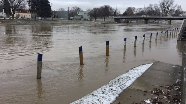
“Water levels have reacted quickly to the rain, with many areas of the Sydenham River flooded into the natural floodplain and low-lying areas,” the St. Clair Region Conservation Authority said in a statement.
The authority says Bear Creek near Brigden and Black Creek near Bickford Line are showing early signs of cresting. That means the river has reached its highest water level before the waters fall back down. However, water levels on both the north and east branches of the Sydenham River continue to rise.
The conservation authority warned this could lead to road flooding, particularly in Strathroy, Petrolia, St. Clair and Enniskillen townships. It urged municipal emergency staff and road crews to monitor conditions closely and report flooded roads and closures.
Below-freezing temperatures expected this week may help slow additional runoff by keeping snow and ice on land. However, the authority says the lack of ice cover on waterways, combined with five to 15 centimetres of snow forecast for Tuesday through Wednesday, could delay water levels from receding.
“Individuals are reminded to avoid watercourses and flooded areas due to dangerous conditions, slippery banks, unsafe ice conditions and swift-moving water,” the authority said. “Children and pets should be kept away from the water.”
Thames River expected to rise downstream
Further east, the Lower Thames Valley Conservation Authority (LTVCA) says water levels on smaller creeks have peaked and are now dropping, but the Thames River is still expected to rise as water moves downstream from the upper watershed. Over the next couple of days, high water levels will work their way downstream.
“As they do, they will flood the low-lying areas immediately adjacent to the river,” the authority said in a statement.
Water levels on the Thames River near London were expected to peak overnight. From there, elevated water is forecast to move downstream through Delaware, Thamesville and into Chatham.
WATCH | Take a look back at the great flood of 2016: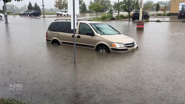
Take a look back at the great flood of 2016
CBC Windsor looks back at the flood of 2016, which ravaged homes and neighbourhoods, changing the way we think about rain.
In Chatham, the authority said “the sidewalk along the river in the downtown is expected to flood over,” and warned that “it is also possible that Simcoe Lane under the 5th St. Bridge gets flooded.”
The conservation authority says water levels along the river should remain elevated throughout the week.
The LTVCA noted most ice has cleared from the Thames River, with only small amounts of ice rubble remaining between Kent Bridge and Communication Road in Chatham. While that ice could temporarily raise water levels, the authority says it presents little risk of ice-jam flooding. Ice-jam flooding happens when chunks of river ice pile up, forming a temporary dam that blocks water flow and causes water levels to rise rapidly.
“People should take extra caution and avoid the river, ditches and streams,” the authority said. “Any remaining ice on these watercourses should be considered unsafe.”
Essex Region remains stable
Meanwhile, the Essex Region Conservation Authority says shoreline and watershed flood conditions in its area remain green, indicating no immediate flood risk.
All conservation authorities say they continue to monitor conditions and will issue updates if flooding worsens.