
Communities across north Queensland are being warned heavy rains and risks of flash flooding are expected to continue over the next 24 hours, as ex-Tropical Cyclone Koji soaks the region.
The ex-cyclone crossed the north Queensland coast between the towns of Ayr and Bowen earlier today, weakening into a tropical low pressure system.
However, authorities said heavy rainfall remained a concern, with the Bureau of Meteorology (BOM) predicting some areas could see up to 340 millimetres in the next 24 hours.
Areas between Ayr and St Lawrence are tipped to get the worst of the weather today, but it could move further south and inland in the next 24 hours, according to the BOM.
“The system has the potential to produce locally more intense rainfall, which may produce life-threatening flash flooding,” forecaster Sue Oates said.
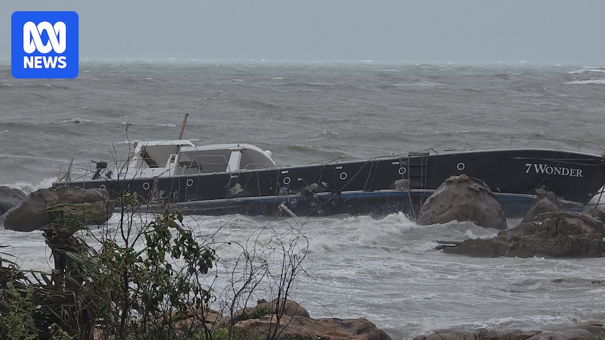
A large boat washed onto rocks as Ex-Tropical Cyclone Koji hit Bowen on Sunday morning. (Supplied: Chris Georgieff )
Strong winds and rough ocean conditions have led to several boats off the coast of Cannonvale breaking free of their anchorages and being pushed on to shore.
Disaster and emergency management deputy commissioner Chris Stream said two men managed to swim to safety after a boat sank near Pigeon Island this morning.
He said two men and five children were rescued from a Finch Hatton home today, west of Mackay, after being trapped by rapid creek rises.
“At one stage, the water caused them to climb up onto tables,” he said.
Loading…
He also renewed warnings after a woman in Bogie, south-west of Bowen, drove into floodwater with two children.
“Luckily [they] were able to self-extract and walk to a nearby homestead whereby they were able to receive assistance,” he said.
Queensland Premier David Crisafulli said crews were working to restore power to about 15,000 homes, with most outages in the Mackay and Whitsundays regions, according to Ergon Energy.
The Bruce Highway is cut at Peter’s Flat just north of Bowen and both the Proserpine and Mackay airports remain closed, however Townsville Airport has reopened.
The BOM has cancelled its warning for Townsville and said wind gusts of up to 113 kilometres per hour were recorded at Hamilton Island as the system approached the mainland.

Impacts from the Ex-Tropical Cyclone Koji are expected to be felt from Ayr south to Mackay. (BOM)
BOM forecaster Angus Hines said the worst of strong winds was expected to be “done and dusted” by midday.
Ex-Tropical Cyclone Koji had been downgraded from a category two system overnight.
Loading…”Rain is going to be the main focal point really as today progresses,” Mr Hines said.331mm of rain in six hours
Major flood warnings are in place for north Queensland catchments including the Pioneer River, Georgina River and Flinders River.

Whitsundays residents say they’re feeling the first impacts ahead of Tropical Cyclone Koji. (Supplied: Kerri Smit)
The heaviest falls so far include Clarke Range, inland of Mackay, which recorded 362mm of rain in the 24 hours to 9am on Sunday and Mattie O’Neil Bridge which received 331mm in six hours.
Cattle Creek, west of Mackay, saw 370mm in the last 12 hours.
Mackay Mayor Greg Williamson said authorities were closely monitoring the falls and urged people to be wary of floodwater.
“We’re really concerned about the amount of water that’s associated with this cyclone,” Cr Williamson said.
“The big message is, if it’s flooded, forget it. Don’t go sightseeing. There’s a real chance of flash flooding in some areas.
“We’re not out of the woods yet.”
Mr Hines said falls between 100mm and 200mm could fall across a large part of the north Queensland, with falls as far south as Rockhampton.

Residents at Toolakea Beach prepared sandbags yesterday before the cylclone hit north Queensland. (ABC North Queensland: Baz Ruddick )
Mr Hines said the storm appeared to be a “lopsided” system with most of the rainfall dumped south of the storm, where six-hourly rainfall totals of up to 150mm could be experienced.
“The persistent heavy rain and potential for flooding is really on the southern flank of this system.”

Mission Beach began feeling the impact of Cyclone Koji yesterday. (ABC Far North Qld: Chris Testa )
Extra SES members, as well as Queensland Police and Ambulance officers, have been placed in the Whitsunday Islands in anticipation of the cyclone’s impact.
In an emergency phone Triple Zero
Whitsundays Mayor Ry Collins said the impact of the storm was being felt.
“It’s howling out there at the moment,” he said.
Mr Collins said the area had already received about 150mm of rain and some roads are already impacted by floodwaters, including a section of the Bruce Highway just outside of Bowen.
“We encourage everybody throughout the region to take the advice and make sure they’re prepared for what’s coming.”
Ergon Energy spokesperson Justin Coomber urged residents to report and stay away from any downed powerlines and treat them as if they are live.
“We’ll get out and restore power as soon as it’s safe to do so,” he said.