
By ABC meteorologist Tom Saunders, ABC News
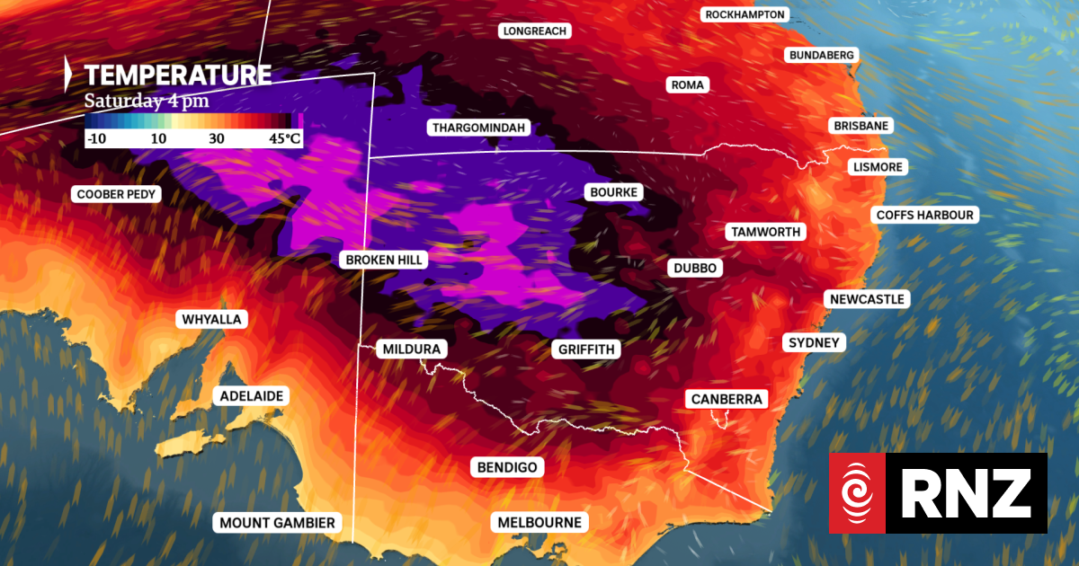
The hottest air will impact southwest NSW, where maximums will peak in the high 40s.
Photo: Supplied / ABC News
For the eighth consecutive day, Australia’s southeast inland will bake in temperatures well above 40 degrees Celsius.
Today’s forecasts include maximums of up to 49C, following a high of 50.0C at Port Augusta on Friday – the farthest south 50C has been officially recorded in Australia.
A long-awaited southerly change has now arrived on the southern coastline, and the cooler air will head north and finally erode the record heatwave during the next 48 hours.
Marathon heatwave to deliver a final day of sweltering
The heatwave that rapidly developed last weekend is now up to day eight, thanks to an immovable dome of hot air over southeast Australia created by high pressure above the surface.
The absolute highest temperatures under the heat dome have shifted slowly anticlockwise through the week, spending the past two days over South Australia.
Along with the 50C at Port Augusta, Friday’s maximums also included new records of 49.7C at Tarcoola and 49.6C at Woomera.
In other states, 48.1C was recorded at Smithville (NSW) on Friday, 47.3C at Ballera (Queensland) and 45.1C in Mildura (Victoria).
The hottest air will shift back to western NSW today and the odd record could again tumble, most likely in Ivanhoe, where 49C is predicted.
Elsewhere, mid-40C heat will return to inland SA, the Mallee and south-west Queensland, with some of the more notable Saturday forecasts including:
NSW
49C at Ivanhoe, a possible record. Current record 48.5C in February 2004.
48C at Wilcannia.
47C at Menindee.
SA
47C at Moomba.
47C at Marree.
Queensland
46C at Thargomindah.
46C at Birdsville.
Victoria
As the hottest air shifts east, a hot day is also ahead for eastern NSW on Saturday. Western Sydney can expect to reach up to 38C and the inland Hunter up to 43C.
While the inland sweats, onshore winds will keep the NSW coastal fringe closer to about 30C, similar to temperatures recorded all week.
Maximums to drop up to 18C in 24 hours
A cooler southerly airstream has now brought relief near the southern coastline and will be re-inforced by a cold front heading towards Tasmania tonight.
The arrival of polar air just off the mainland coast will displace the heat dome north, allowing southerly winds to penetrate well inland and lower temperatures across southern states on Sunday.
So when will the cooler air reach each region?
As a general guide, northern Victoria and southern pastoral regions of SA can expect a noticeable drop in temperatures later tonight. For example, after hitting the low 40s, Renmark should cool to about 21-22C by midnight.
The change will then cross the Murray River overnight and push into far southern NSW early Sunday, before reaching central NSW about the middle of Sunday.
Maximums will drop about 10-15C right across southern inland NSW, northern Victoria and eastern SA, with an extreme up to 18C in Seymour, falling from 39C to 21C.
However, much of northern inland NSW and southwest Queensland will suffer another night above 30C, and still climb well above 40C on Sunday, before the southerlies arrive at night.
A week for the record books
This week’s oppressive heatwave has been unprecedented for both its longevity and peak intensity, with all-time high temperatures spread across multiple states.
The national highest temperature of 50.0C was shared by South Australia’s Andamooka and Port Augusta, followed by 49.8C at Marree, also in SA, and 49.7C at Pooncarie in NSW.
Victoria’s highest maximum this week was 48.9C at Walpeup and Hopetoun, a state record, while Queensland’s top was 48.5C at Thargomindah.
In the ACT, Tuggeranong hit 43.5C, and Ouse in Tasmania reached 37.0C.
Overnight temperatures have also been noteworthy, headed by a 34.2C minimum at Marree, and several outback towns failed to drop below 30C for more than 100 consecutive hours, including Oodnadatta and White Cliffs.
The duration of high maximums is also significant, but for most areas, the run of 7-8 days in a row above 40C was last achieved fairly recently. For example, Mildura endured 12 consecutive 40C days in 2009.
The exception is the eastern Riverina, where today marks the first time seven 40C days have been recorded since 1939.
However, analysing days above a higher mark, for example, seven above 46C in Ivanhoe or eight above 44C in Broken Hill, reveals that, in that respect, this heatwave is the worst on record.
– ABC