
A swathe of rain warnings and watches have been issued for parts of the North Island from Friday, as humid conditions are set to sweep across the country.
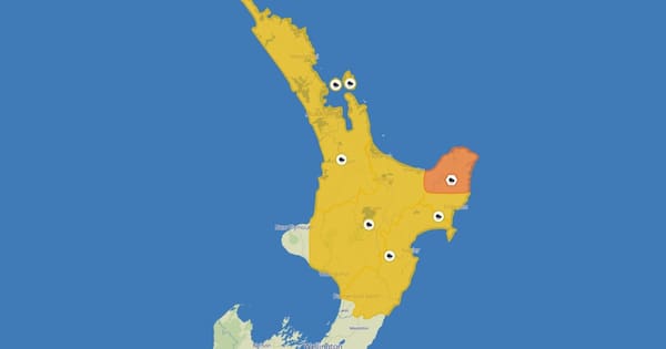
MetService issued an orange heavy rain warning for Bay of Plenty east of Ōpōtiki and Gisborne/Tairāwhiti north of Tolaga Bay from 8pm Friday into Saturday.
“Expect 80 to 100 mm of rain to accumulate, with the chance of 130 to 150mm in one or two places,” the forecaster said.
“Peak rainfall rates are very dependent on localised convection or thunderstorms, and may reach 25 to 35mm per hour during Saturday morning.”
Northland, Auckland (including Great Barrier Island), Coromandel Peninsula, Waikato, Waitomo, Gisborne/Tairāwhiti from Tolaga Bay southwards, Manawatū, Tararua District and Hawke’s Bay were also issued yellow heavy rain warnings throughout Friday.
The morning’s headlines in 90 seconds, including the girlfriend caught up in an Olympic cheating scandal speaks, and the place no one wants to see a shark. (Source: 1News)
“These conditions are likely to lead to thunderstorms developing and there is a chance of localised downpours in some North Island places.
Although the risk of downpours is low to moderate, these could have significant impacts if they occur,” MetService added.
MetService meteorologist Alwyn Bakker said the front moving up the South Island on Friday would bring a burst of heavy rain to western areas, with some rain making it east of the Alps.
“A southerly moving through on Saturday brings heavy showers and potential thunderstorms for Otago and Canterbury during the second half of the day,” Bakker said.
“While the low centre developing east of the North Island will be driving much of the weekend weather, its exact position is still uncertain. This means it is tricky to nail down the intensity and location of potential severe weather.
Bakker said the forecast position may change from one day to the next, and urged people to check the forecast over the weekend.
“We’re currently predicting the rain will stay away until the tail end of Wellington’s Round the Bays on Sunday, which should motivate participants to keep up the pace. However, there will still be strong southerlies during the races, so take advantage of those tailwinds when you can.”
High temps set to turn
This morning, MetService meteorologist Mmathapelo Makgabutlane said the top of the South Island awoke to a “murky morning”, with cloud lingering about for some areas including Mt Cook Airport.
She said temperatures remained high across both islands today, including a “very warm day” in Invercargill with a high of 28C, while Alexandra would hit a high of 30C.
“It’s a warm day all around, with a heat alert for Upper Hutt,” she said.
However, Bakker said the run of warmer-than-average temperatures would likely end this weekend.
“We still have a couple of days of warmer temperatures and high humidity ahead of us, but things are set to change this weekend as cooler air pushes in from the south.
“A lot of the South Island will have a cooler-than-average weekend, with a few locations seeing a difference of more than ten degrees between Friday’s and Sunday’s maximum temperatures. Cooler temperatures move up the North Island through Saturday and should stick around into early next week,” Bakker advised.