
Antarctica holds about 90 percent of the ice on Earth. Most people picture it as a frozen place that barely changes. In reality, the ice sheet along its edges is always moving, shifting, and responding to the ocean around it.
A new long-term study now offers one of the clearest insights yet into how that ice is behaving. The picture is mixed.

Much of Antarctica’s coastline has stayed stable for decades. Yet certain areas are retreating, and those changes could shape the future of global sea levels.
A closer look at the ice edge
When the massive glaciers meet the ocean, an important transition occurs. The ice, which was formerly grounded on bedrock, begins to float. The boundary between grounded and floating ice is called the grounding line.
The grounding line matters because when it extends further inland, this means that glaciers are no longer grounded and are sliding more quickly into the ocean. The ice sheet is more vulnerable to collapse.
Scientists have now monitored how these boundaries have changed over the last three decades. The researchers used radar satellite imagery between 1992 and 2025 to create the most detailed record yet of the movement of the grounding lines.
The results show that more than 77 percent of Antarctica’s coastline remained stable during that time. Large ice shelves such as Ross, Filchner-Ronne, and Amery showed little change in their grounding lines.
Trouble spots around the continent
Stability across most of the coastline might sound reassuring. But the remaining sections tell a more worrying story.
Researchers found clear signs of retreat in several vulnerable areas. These included parts of West Antarctica, sections of East Antarctica, and the Antarctic Peninsula.
The most dramatic changes appeared along the Amundsen Sea coast in West Antarctica. In some locations, the grounding line moved inland by as much as 26 miles (42 kilometers) during the study period.
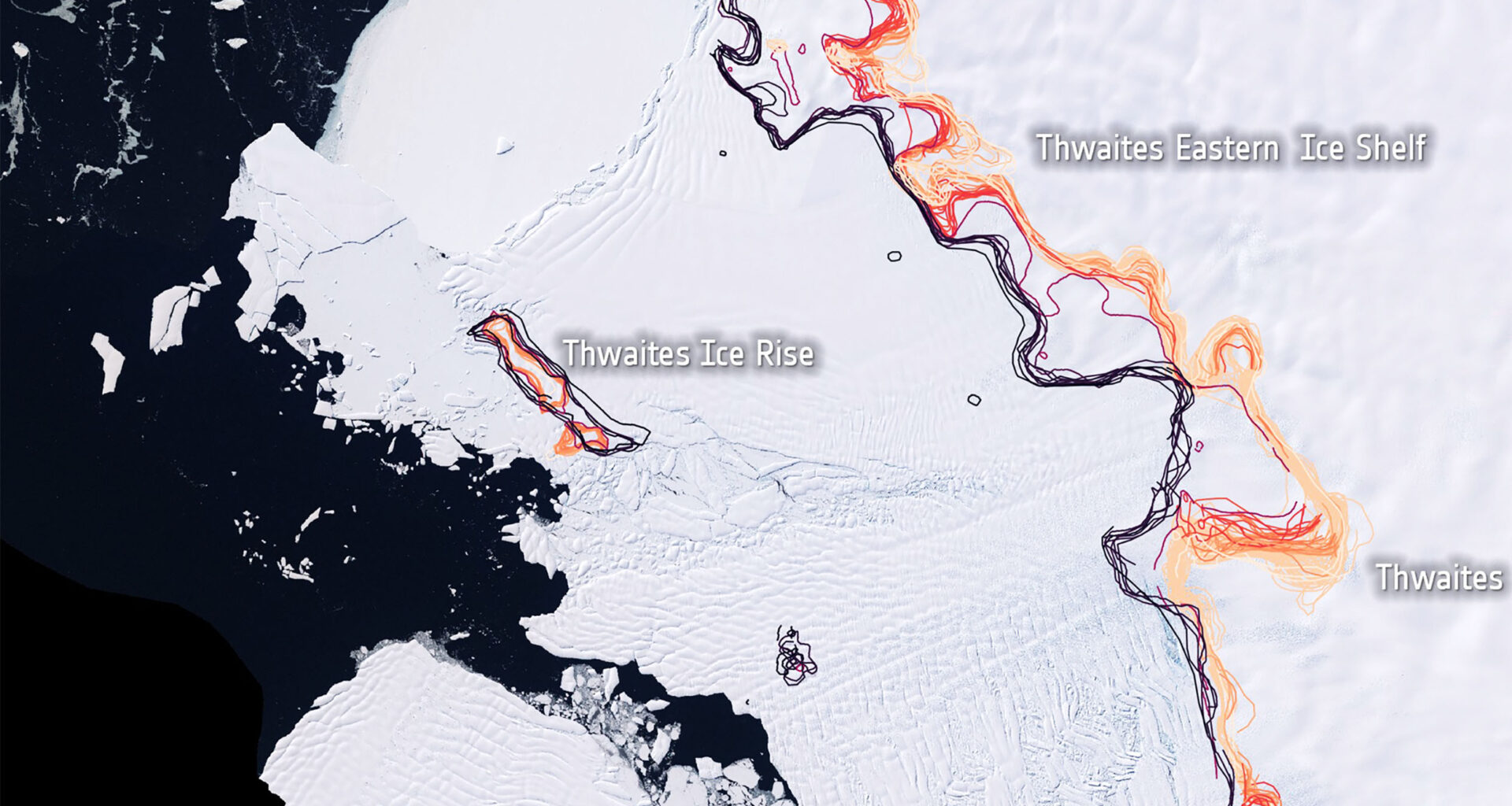
Glaciers near East Getz, Smith, Thwaites, and Pine Island showed some of the strongest shifts.
When scientists totaled the changes across the continent, the numbers added up quickly. Antarctica lost roughly 4,942 square miles (12,800 square kilometers) of grounded ice between 1996 and 2025. That area is close to half the size of Belgium.
Why warm water matters
One of the major factors that contributes to a glacier’s recession is located beneath the surface of the ocean.
Warm water currents, known as Circumpolar Deep Water, can flow beneath the surface of floating ice shelves. If this water reaches the glaciers, it melts the ice from beneath.
The situation in some areas is even worse. Underneath the glaciers in some areas, the ground slopes downwards towards the center of the continent. Once the glaciers start retreating, they continue retreating down this slope.
Scientists also discovered that the grounding line is not a single fixed edge. It behaves more like a shifting zone. Ocean tides lift and lower floating ice, while water flowing beneath glaciers changes how the ice interacts with the ground.
Because of that movement, the research focused on mapping entire grounding zones rather than just a thin boundary line.
Antarctica’s ice sheets from space
Monitoring these slight changes over the whole continent would be almost impossible from the ground alone. Satellites made the difference.
The research team employed the help of radar devices from a number of satellites that observe the Earth from space, including the Sentinel-1 satellites. The radar devices are useful for observing the Antarctic environment since they can penetrate clouds and observe the area during polar darkness.
A technique called differential interferometry was employed by the team in their research. This involved analyzing radar signals from the same place at two or more different times. The technique can detect slight changes in the surface of the ice, including changes as small as fractions of inches.
Clues from movements of floating ice
Ice shelves that float can be expected to rise and fall with the ocean tides. However, the ones that are grounded do not behave in the same way since they are anchored on the bedrock.
By monitoring the slight changes in the grounded ones over time, the team was able to establish where the grounding zone was.
The study combined data from a wide range of missions. Along with Sentinel-1, scientists analyzed observations from Europe’s ERS satellites, Canada’s RADARSAT, Japan’s ALOS PALSAR, Italy’s Cosmo-SkyMed, Germany’s TerraSAR-X, Argentina’s SAOCOM satellites, and the ICEYE constellation.
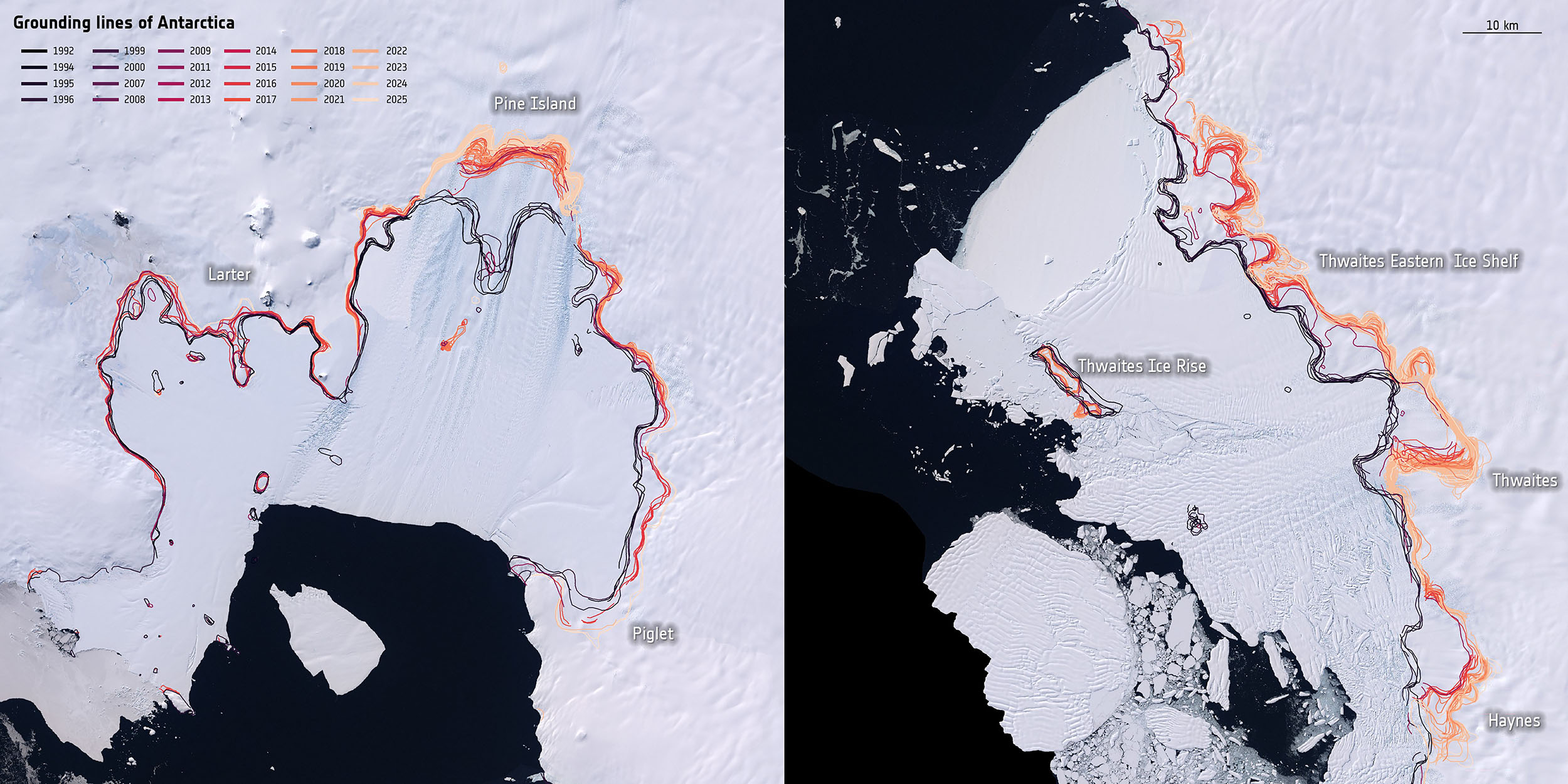 Grounding line retreat on West Antarctica ice sheet from 1992-2025. Credit: ESA. Click image to enlarge.What the scientists say
“This work would not have been possible without the unconditional support of international agencies to make observations of the polar regions available to us,” said Eric Rignot of the University of California, Irvine.
“As satellite observation capabilities continue to expand, we are looking forward to learning more about the dynamics of these systems so we can better project how they influence sea-level rise in the future,” he added.
The work also drew attention from the European Space Agency. Nuno Miranda, ESA’s Sentinel-1 Mission Manager, highlighted the importance of the decades-long record created by combining many satellite missions.
“By combining multiple satellite missions into a consistent long-term dataset, researchers have established a benchmark for future modelling efforts,” he said.
Future of Antarctica’s ice sheets
Antarctica’s ice sheet holds enough frozen water to raise global sea levels by many feet if it were to melt completely.
That process would unfold over centuries, but small changes today help scientists understand where the system might be heading.
The new record of grounding zone movement offers a clearer baseline for future studies. It shows where the ice sheet is holding steady and where it is beginning to lose ground.
Antarctica may look still and silent from afar, but underneath that calm surface the edges of the continent are constantly adjusting to the ocean that surrounds them.
Continuous satellite monitoring is giving scientists their best chance yet to keep track of those changes as they unfold.
Information from the European Space Agency.
—–
Like what you read? Subscribe to our newsletter for engaging articles, exclusive content, and the latest updates.
Check us out on EarthSnap, a free app brought to you by Eric Ralls and Earth.com.
—–