
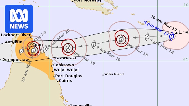
A tropical low in the Coral Sea has officially been declared Tropical Cyclone Narelle.
The Bureau of Meteorology (BOM) said the system, currently a category one, was about 1,200 kilometres north-east of Cooktown and heading towards Cape York.
It may reach category four by the time it crosses the Far North Queensland coast, possibly on Friday, bringing destructive winds and heavy rain.
“A severe impact is likely late in the week,” the bureau said.
The bureau’s track maps show the system crossing into the Gulf of Carpentaria at the weekend before heading towards the Northern Territory.
The watch zone is Lockhart River to Port Douglas and adjacent inland areas.
Destructive wind gusts to 155km/h are possible from Thursday evening between Coen and Cooktown.
Bureau of Meteorology forecaster Baden Gilbert said communities between Port Douglas and the Lockhart River could expect gale-force winds in the next 24 to 48 hours.
“At the moment we’ve got it reaching the Far North Queensland coast on Friday morning,” he said.
“There is some guidance that it could move a little bit quicker and arrive during Thursday.
“[Some forecasts have] it lagging a bit more into the back end of Friday, with gales potentially picking up ahead of that system reaching the coast.”
He said the already-soaked parts of the state’s far north could expect 200 millimetres of rain, with up to 300mm in some areas.
“We’re forecasting it to reach a category one system tonight, then potentially reaching category two tomorrow, before reaching category three before it makes landfall on Thursday into Friday,” Mr Gilbert said.

The Daintree River at Daintree Village rose to a high of 7.25 metres on Sunday, a week after flash flooding rose sharply in the night, damaging boats and river infrastructure. (Supplied: Vince O’Flaherty)
Ongoing recovery
Communities north of Cairns are still recovering from heavy rain following tropical low 29U earlier this month and a drenching on Saturday night and Sunday morning, with hundreds of millimetres recorded in official gauges.
Dean Clapp, from Crocodile Express, is one of three commercial tour operators who lost boats in intense floods on the Daintree River this month, ahead of the lucrative Easter tourist season.
“Anything that’s not properly secured could go missing,” he said.
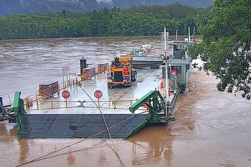
The Daintree car ferry is inoperable because of damage, but local river cruise boats are providing crucial pedestrian access to the northern Daintree communities. (Supplied: Douglas Shire Council)
One of his boats, the Jungle King, was washed about 20km down the Daintree River and out onto the Great Barrier Reef.
The boat has been recovered, but he estimates a damage bill of $100,000.
“This is a blip, which is hard to take every now and then, but we’ll get through it,” he said.
Another of his boats is taking locals and tourists across the Daintree River in place of the local council car ferry, which was damaged and is being repaired.
Cyclones – what to do
One of the Cape communities keeping an eye on a possible cyclone is Coen, about 40km west of the east coast.
Resident Sara Watkins, who runs The Little Bush Pantry, estimates about 200 people are in town, fewer than the Australian Bureau of Statistics 2021 count of 322 people.
They have been effectively stranded since mid-January because flooded rivers have cut the seasonal Peninsula Development Road.

Sara Watkins runs The Little Bush Pantry in Coen, on Cape York Peninsula in Far North Queensland. (Supplied: The Little Bush Pantry)
While she says her store and another local store have about three weeks of supplies, her main concern is keeping goods fresh if they need to switch to generator electricity.
“If this cyclone knocks out the power, we might struggle to keep those bits good enough for people to eat,” she said.