
Tropical Cyclone Narelle is threatening to continue its trail of destruction as it moves inland after crossing northern Queensland coastline.
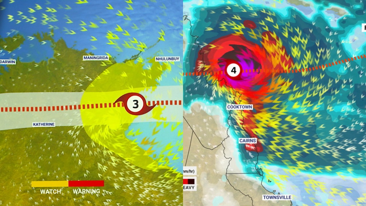
The dangerous storm system is currently category four and is moving westward between Lockhart River and the small town of Coen, bringing destructive winds and heavy rain.
The severe storm is moving westwards, north of Coen, cutting through the Cape York Peninsula as it sweeps across to the Gulf of Carpentaria.
Residents in areas were asked to remain in place as torrential rain is expected to lash the region, as well as destructive wind gusts of more than 200 kilometres per hour, according to the Bureau of Meteorology.
The cyclone is expected to take up to 18 hours to cross the Peninsula and move into the Gulf.
It’s expected to reintensify as it moves into the Northern Territory.
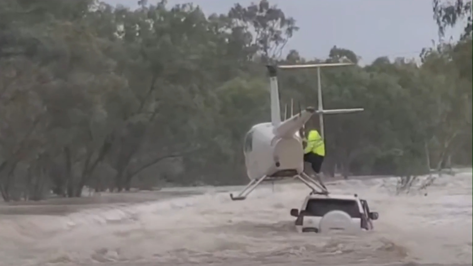
About 230 homes are without power across the Cook Shire Council area, including 70 in Lockhart River where an emergency alert has been issued for fallen powerlines.
The Department of Transport and Main Roads has closed the Peninsula Development Road from Laura and then Coen to Weipa.
Tropical cyclone downgraded to category three
Tropical Cyclone Narelle has been downgraded from a category four system to category three as it moves inland across the Cape York Peninsula.
Areas in the warning zone include the Cape York Peninsula between Lockhart River and Cape Melville, and between Mapoon and Pormpuraaw, including Coen, Weipa and Aurukun.
“Severe Tropical Cyclone Narelle crossed the Queensland coast around 7am AEST about 75 kilometres south of Lockhart River as a category four system,” the Bureau said in its latest warning.
“Narelle is now moving westwards, currently passing about 45 kilometres north of Coen, and has weakened to category three.
“It is forecast to move west over Cape York Peninsula today, continuing to weaken but remaining a tropical cyclone.”
Narelle is expected to strengthen to severe tropical cyclone intensity as it tracks west towards the Gulf of Carpentaria before impacting Northern Territory’s east from late Saturday.
At noon, the Bureau recorded sustained winds of 155 kilometres per hour near the centre of the cyclone and wind gusts up to 220 kilometres per hour.
Tropical Cyclone Narelle makes landfall
Tropical Cyclone Narelle has made landfall in Far North Queensland, crossing the coast between the Lockhart River and Coen about 7am AEST.
The system, tracking west at a speed of 23 kilometres per hour, is forecast to move over the Cape York Peninsula during Friday while weakening, according to the Bureau.
Narelle is expected to continue to move west across the Gulf of Carpentaria before it strengthens again to a severe tropical cyclone as it impacts eastern pockets of the Northern Territory from late Saturday.
At 7am AEST, the cyclone had sustained winds of 195 kilometres per hour near the centre and wind gusts of 270 kilometres per hour.
‘Stay where you are’: Premier’s warning to Queenslanders
Speaking at a media conference as the cyclone crossed the coast, Queensland Premier David Crisafulli urged residents in the line of Narelle to secure shelter immediately.
“My message to Queenslanders right now is this – we have prepared, you have prepared – the best place right now is to remain exactly where you are,” he said.
“The challenges that we are preparing for to hit the coastline are as follows: Wind, storm surge, rain. And then the prospect of flooding.
“Wind is intensifying, in many cases it will be the strongest wind that people have experienced in this part of the state for a long, long time.
“I want to assure the community there will be no daylight between response and recovery.
“But right now the message to people is to stay where you are in the remaining hours as the system has only just started to cross the coast to the western side of the Cape.”
Mr Crisafulli said there was already flash flooding, erosion and power outages taking place.
“We’re approaching high tide, which is due a little later on in the morning, so we’re likely to see that rise again, and we’re asking people to take caution in that regard,” he said.
“There’s a lot of rain in this system, and as it moves, it will be hard and fast.”
Currently 14 schools have been forced closed, including campuses in towns north of Daintree State School and on both sides of the Cape.
The Premier has assured residents in those isolated towns that they will get through this once-in-a-lifetime storm.
“It will still be a significant system for many of those communities in the Western Cape, and we’re asking them to do as they do well, and that is to be prepared,” he said.
“This is a remote part of the state, and it’s not a highly populated part of the state.
“But it’s a part of a state that matters to us, and they’re great communities.
“I just want to assure those communities that they matter and that whilst small in number, they’re big on our identity as who we are as Queenslanders, and we’re really determined to make sure we get through with everyone in one piece.”
Cyclone downgraded to category four
Earlier, the Bureau downgraded the system from category five to category four status.
The Bureau has warned very destructive wind gusts exceeding 250 kilometres per hour are possible near the centre of the cyclone as it crosses the Cape York Peninsula coast.
Destructive wind gusts up to 160 kilometres per hour are likely south of the Lockhart River, to the north of Cape Flattery.
Earlier, Sky News Weather meteorologist Marina Neuman warned the category four system was swiftly moving in a westerly direction.
“Currently (Narelle) it does have max wind speeds of 195km/h … it is heading west and it is going to continue its track as a category four storm, as it pushes into the Northern Territory,” Neuman said.
“Right now, it is bringing very strong winds along the coastline.
“We have seen very heavy falls bringing in widespread rain all the way from the top, through Cooktown and through Cairns.”
Flood warnings have been issued across northern Queensland and the NT, and locals around Princess Charlotte Bay have been urged to prepare for the possibility of a “dangerous storm tide” on Friday.
Earlier, Sky News Weather presenter James Preston warned inundated communities in the Top End were at greatest risk, saying the cyclone was “not good news” for those impacted by floods along the Daly River.
Preston said parts of the NT had seen rainfall in excess of 200 millimetres over the past seven days.
Areas between Port McArthur and south of Nhulunbuy are forecast to see wet weather, particularly on Saturday, as Tropical Cyclone Narelle passes over the region.
Coen residents ‘bunker down’
Earlier, Coen resident and business owner Sara Watkins told Sky News that anxiety levels were increasing in the remote town as the category four cyclone closed in.
“Winds started here at about 4am. We can hear some debris moving around so there must be a pretty strong gust coming through,” Ms Watkins said, while bunkered down in a sheltered room.
“A lot of people moved into bricked shelter in town just last night.
“Let’s get bunkered down, let’s get safe.”
Cook Shire Mayor Robyn Holmes said her main concern was the destructive winds.
“Everyone has done as much as they possibly can at this point. It’s a matter of bunkering down and will be there at the other side of the storm,” she told Sky News earlier on Friday.
“My main concerns are the destructive winds and the impact they will have, in particular on the Coen community and those east coast communities.
“We’re just hoping that anyone who hasn’t had a safe place to bunker down, is in there at the moment, because that facility will be closed for the crossing of the storm.”
Small towns to bear the brunt of the storm
Speaking earlier to Sky News, Emergency Management Minister Kristy McBain said Coen and Cooktown would likely be hit the hardest by the storm.
“It has already been a pretty dramatic wet season in the north… catchments are pretty full already, the grounds are pretty soggy,” she said.
“We expect will see a lot of trees down, people need to be careful if they’re on the roads.
“Stay home and enact your emergency plan as soon as possible.”
Narelle could be the ‘biggest’ weather event in living memory
Premier Crisafulli has repeatedly warned this week that Tropical Cyclone Narelle could be the biggest event in living memory for those in the state’s north.
“Today really is the last day this is the final window for people to make sure that they’ve got a plan, their yard is clean, they got the supplies they need,” Mr Crisafulli told Sky News on Thursday.
“A lot of staff on the ground we’ve got police going door to door, we’ve got a lot of emergency, medical crews, firefighters on the ground ready to respond. I hope that shows how seriously we are taking it.
“The state government is taking this event seriously… this is a big event. Many cases it will be the biggest event that people have experienced.”
 National Friday forecast
Residents in the path of the cyclone have been advised to seek shelter in a safe place and to contact emergency services if their situation becomes life-threatening.
While not at risk of the same wild weather facing Queensland and the NT, New South Wales residents have been told to expect wet and stormy conditions on Friday.
“Plenty of thunderstorms floating about, all tracking from the west and then gradually making their way further east,” Preston said.
Rain has been forecast for much of the state’s coast, including in Sydney where there will be a gloomy end to the week with a top of 27C.
Meteorologists have warned of storms further inland, particularly around Orange and Goulburn.
Further south, meanwhile, conditions have been largely warm and sunny for Victoria on Friday morning, with a top of 21C expected in Melbourne, 27C in Bendigo and 28C in Shepparton.
Tasmanians have started the day to milder weather, with Launceston at 25C, Bicheno at 22C and Hobart at 21C.
A sunny spell has continued in Adelaide on Friday, with the mercury at 27C.
But patchy showers have been forecast for other areas across South Australia, bringing little relief to farms in desperate need of rain.
Preston said Western Australia would continue to bake under what he described as an “eternal summer”, with temperatures in Perth at 34C and 36C in Geraldton.
Despite the cyclone in Queensland’s north, Brisbane locals have settled into a 24C-morning and can expect a top of 28C as the day progresses.
The mercury has been forecast to reach 31C in Darwin – but there will also be rain in the NT capital.
For more information about the cyclone: https://www.disaster.qld.gov.au/