
MetService said strong winds are expected to continue into this afternoon and evening, mainly for the Canterbury and Marlborough regions.
Emergency Management Canterbury spokesperson Rachel Thornton said it’s “important that people stay vigilant”.
“We have had a number of power outages across the South Island – it’s unknown at this stage if this number will rise,” Thornton said.
“But people should remain vigilant until the warning runs out.”
Thornton said people could get updates from Emergency Management Canterbury on its Facebook page.
The NZ Transport Agency Waka Kotahi (NZTA) said it had been called out to incidents involving fallen trees and signage on highways.
NZTA has a general warning in place due to strong winds and is advising road users in the Canterbury region to take extra care, especially those operating light or high-sided vehicles.
“MetService’s red strong wind warning remains in place for Canterbury about and west of State Highway 1,” NZTA said.
“Under this highest level of warning, people are advised to avoid travel due to dangerous driving conditions.”
Mōrena Aotearoa New Zealand
Some overnight stats for you📈
Next Severe Weather Update at 10am!
🔴🌬 A Red Strong Wind Warning for Canterbury remains in place until 3pm today
🟠🌬 Orange Strong Wind Warnings remain in place for much of the South Island
🟠🌧 Orange Heavy Rain… pic.twitter.com/iBamy4bAnv
— MetService (@MetService) September 20, 2025
MetService said Mt Hutt recorded a “very strong” gust of 224k/mh overnight.
Alpine Energy reported several unplanned power outages across much of the region in Milford, Orari, Orton, Rangitata Island, Hunter, Makikihi ,Otaio, Temuka, Winchester and Jacksons Bush.
It stated that their crews were working to restore power and reminded people to treat all power lines as if they were live.
Transport and weather authorities are also advising motorists to stay off the roads.
Fire authorities are also urging people not to light outdoor fires due to the higher fire risk.
‘Damaging winds’ of up to 150km/h
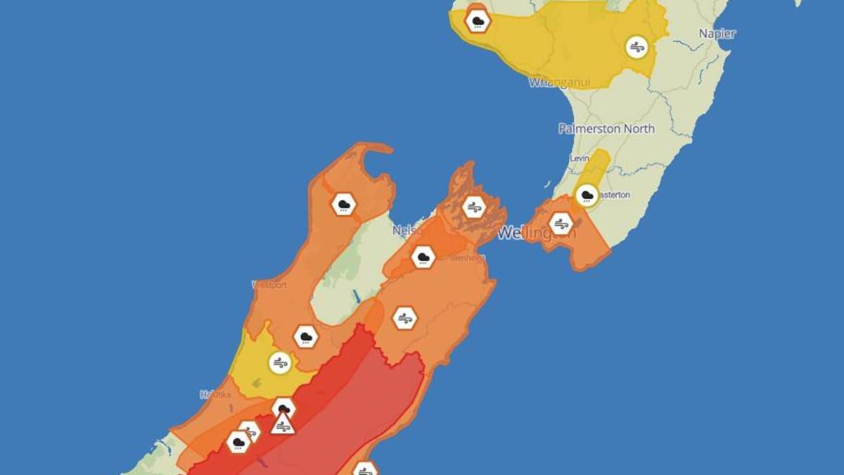
MetService has issued a red strong wind warning – the highest level – for the Canterbury region, saying gusts of up to 150km/h are forecast in exposed places.
MetService’s Saturday advisory forecast a red warning had been issued for the Canterbury High Country for damaging northwesterly winds.
Southland, Fiordland, Queenstown Lakes, Central Otago, the inland parts of North Otago, Dunedin, Clutha, and the Marlborough region (excluding the Sounds) are experiencing severe northwesterly gales gusting at 120 km/h today in exposed areas.
Westland District north of Harihari and Canterbury east of State Highway 1 from Temuka to Lake Tekapo also have orange wind warnings in place.
“It’s looking like a blustery night and an intense Sunday ahead,” MetService said.
“Nearly all of the South Island and parts of the lower North Island are under orange strong wind warnings from late Saturday into Sunday”
“Gusts up to 120km/h are expected in exposed areas.”
MetService advised motorists to avoid travel in Canterbury about and west of the foothills and west of State Highway 1 south of the Rakaia River.
Grey District Council said lampposts had down in Cobden and there were reports of roofs lifting.
“Please stay home and report problems via our Snap Send Solve app or by phoning us” Grey District Council said.
“Staff and contractors are out and about; at this stage winds are forecast to start dropping from 11am.”
Signage has fallen off a fence in the Grey District. Photo / Grey District Council
NZTA reported surface flooding between Kumara Junction and Arthur’s Pass.
MetService said Wellington was next in the wind firing line with an orange wind warning right through until this evening.
Wellington, Wairarapa south of Greytown and the Marlborough Sounds are under a orange wind warning from from 9am today until 3am Monday.
Heads-up for Sunday📣
Strong and damaging northwesterlies could bring:
💨Travel disruptions
💨Difficult or dangerous driving conditions
💨Falling trees, damage to property or powerlines
💨Power outages
Plan ahead and keep up with the latest at https://t.co/qHyE5zySvx pic.twitter.com/zq5f8NVs6Q
— MetService (@MetService) September 20, 2025
KiwiRail has cancelled its Sunday TranzAlpine service due to severe weather.
Today’s 7.45am service from Christchurch to Greymouth and the 2.15pm return journey have both been canned, because of severe rain and gale warnings from MetService.
KiwiRail says no further services are affected at this stage.
The severe winds have the potential to cause threat to life from flying objects and falling trees, the weather authority says, and may cause widespread damage, including downed powerlines.
Fire and Emergency New Zealand district commander, Rob Hands, has made the plea after firefighters’ efforts to put out a scrub fire in Canterbury this week were hampered by high winds.
“We had a foretaste of this last Wednesday, when there were multiple fires across our region – and our firefighters dealt with some very challenging situations due to preventable fires.
“We want to avoid that happening again.”
Hands said the winds will make any fires very hard to control and could easily ignite old fires that have not been completely extinguished.
Anyone who has had an outdoor fire in the last two weeks is being urged to check the site and make sure it is completely out, Hands said.
Members of the public are told to put water on the ash piles or embers if there is any sign of heat.
Heavy rain warnings also in place
Orange heavy rain warnings are also in place for western parts of the South Island-West Coast, the headwaters of Canterbury and Otago lakes and rivers.
The orange heavy rain warning continues into the Tasman region northwest of Motueka and Richmond and Bryant ranges and Rai Valley.
MetService confirmed 83mm of rain had fallen at Mount Cook village in just 6 hours overnight, which equated to 12 mm of rain an hour.
Additionally Milford Sound recorded 64mm of rain overnight.
NZTA said it was responding to reports of flooding on State Highway 6 in Central Otago this morning and surface flooding on State Highway 73 between Kumara Junction and Arthur’s Pass.
People are advised to clear drains and gutters to prepare for heavy rain, avoid low-lying areas and drive cautiously.
Westland is forecast to get heavy rainfall of 80mm on top of what has fallen. Those in the area are advised that there is a risk of flooding, slips and power outages.
“Rivers and streams may rise rapidly and surface flooding is possible.”
The Grey District is also in for strong winds and potential severe gusts in exposed areas. Members of the public are told to secure loose items and be prepared for travel delays.
Anyone in the Buller District should expect windy conditions and rainfall increasing today and tomorrow. People in the area are urged to drive with caution on exposed and elevated roads.
MetService said the combination of strong wind and rain pushed rainfall further inland with the heaviest rainfall east of the Southern Alps.
With school holidays also now under way, authorities are urging those travelling on roads to be extra careful and to keep up-to-date with weather forecasts and warnings.
Sign up to The Daily H, a free newsletter curated by our editors and delivered straight to your inbox every weekday.