
The worst of the weather is forecast to start tomorrow, with peak rates initially reaching between 15-25mm per hour (mm/h) and gradually increasing from 25-40mm/h.
The red warning means conditions are expected to make some roads impassable and potentially isolate communities.
Whangārei District Council said people who felt unsafe in their home and chose to leave should take their pets as well as a grab-bag with four to five days’ worth of clothes, medicine and other essentials.
Mōkau resident Donna Ruka, whose home flooded in January, has packed her bags and moved her two vehicles to the neighbouring Mōkau Marae amid the weather warnings.
Her son’s 4WD remains at home in case her family need to drive through floodwaters to access the marae, though they would move earlier if they needed to.
Ruka’s earlier experience has made her prepare for the incoming downpours.
“It’s almost like you feel the trauma of what happened before … it’s sitting there because you know what we could potentially be in for.”
Mōkau Marae is set up for whānau needing a safe space.
Whangārei District Council said the pilot service on Kaiikanui Rd would be stopped on Thursday because of contractors’ safety.
The service helps safely connect about 800 homes in Ōakura, Helena Bay, Teal Bay and Whangaruru which are hemmed in by a huge slip on Russell Rd, at the Helena Bay hill.
The council said warning levels and weather impacts would determine whether the pilot service would run on March 27.
“If you must travel on Kaiikanui Road during this weather event, take extreme care, travel during daylight hours if possible and keep your speed below 30km. If you can, take the alternative route out via Ōpua.”
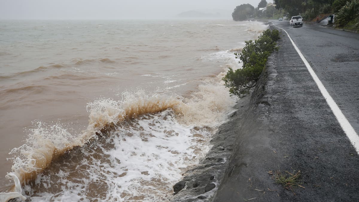
Heavy rain could cause flooding and bring mud, water and debris down on properties.
The council said people should not be in buildings with red and yellow stickers from the last weather event.
Whangārei Mayor Ken Couper said the weather event was the “last thing we need now”.
The storm-hit Ōakura coast still had 20 people in emergency housing following this year’s earlier weather bomb, and up to 40 people were still reliant on marae facilities daily.
“So we are doing a social needs assessment to get a really good understanding of who we’ve got out there and what we need,” Couper said.
The National Emergency Management Agency [Nema], Fire and Emergency New Zealand and central Government agencies would all work with the council where required, he said.
“It’s ironic really, because we are still doing the recovery from the last event, so we have systems in place and good communications going within the region and within the agencies that we potentially will need again.”
Couper said it was a “little bit early” to say whether there would be a state of emergency placed on the district.
The council was assessing whether to stand up an emergency operations centre this afternoon, he said.
Far North District Council said residents should avoid areas with landslides, steep slopes, streams, creeks and rivers.
Kaipara District Council encouraged people to download the Antenno app in order to stay informed.
The council’s roading crew are doing network sweeps to make sure culverts and cesspits were open and flowing.
Crews were on standby to deal with potential fallen trees blocking roads.
The Emergency Operations Centre (EOC) was on standby and will be stood up immediately when required.
Marae open for communities in need
Some marae and safe spaces had been opened for whānau who need spaces to go.
They include Tūparehuia Marae, Mōkau Marae, Ōakura Sports Complex, Ngaiotonga Marae, Ngunguru Marae and Otetao Marae.
“If you or your whānau need a safe place, please don’t hesitate to head to one of these locations,” a post on the Ngātiwai Trust Board’s Facebook page read.
Northland Civil Defence Emergency Management Group spokesman Zachary Woods said district councils were the best places to report issues with and receive updates on local infrastructure, such as roads.
“If centres or marae are opened to provide support, they will be published on the district council websites.”
Woods said councils, emergency services and Northland Civil Defence were meeting regularly and co-ordinating closely before the event.
“We are working with MetService and the Northland Regional Council Hydrology team and positioning resources across the region to respond effectively if needed.”
He said Northland Civil Defence would share updates as conditions develop.
Northland schools evaluating risk
Kamo Intermediate School advised caregivers on Facebook this afternoon that the kura (school) would be open for instruction tomorrow, but students living out of town and unable to get to school had the option to work from home.
“Some of our staff will also have to contend with the rising tides, slips and surface flooding that we are all expecting, so they may be teaching online tomorrow, from home.”
“Please note this is not an invitation for all students to work from home; it is out of safety that we invite students who are affected by the weather to do so.”
Meanwhile, Kaikohe East School said caregivers were welcome to collect their child early today and limit travel where possible.
Tauraroa Area School and Maungakaramea Primary School said it would keep an eye on the forecast and would advise of any updates regarding closures or bus changes.
Waiotira School requested caregivers kept notifications turned on in case they needed to post urgent updates regarding closures or bus changes.
Orange heavy rain warning for Northland
The rest of Northland is under an orange heavy rain warning from 4pm today until 4am on Friday.
MetService said there was a high chance the remainder of the region could be blanketed in a red warning too.
Between 150-250mm of rain is expected to fall, with peak rates starting at 15-25mm/h and increasing to up to 40mm/h and possibly more through to Friday morning.
Thunderstorms are possible from tomorrow afternoon.
Northland is also under an orange strong wind warning lasting from 9pm tonight until 11pm tomorrow, with severe gale and east-to-northeast winds gusting 120km/h in exposed places.
MetService meteorologist Mmathapelo Makgabutlane said a red warning was because it was a “multi-hazard” weather event.
Coastal areas in particular were set to be battered by the combination of heavy rain and powerful winds, with Makgabutlane warning of swells along the eastern coastline in excess of 4m.
Although the last month has been on the “drier side”, she warned that steady, heavy rain over the coming day could saturate soil before “real intense” periods are expected to hit tomorrow.
“The entire period of the red warning is possibly impactful, but especially from Thursday afternoon and evening,” she said.
Flooding, slips and dangerous road conditions were expected.
Strong winds could damage trees and powerline structures as well, she warned.
Makgabutlane said even with an orange weather warning, there was a danger to life and property.
Now was the time to prepare, she said, encouraging people to heed advice from agencies on the ground, such as local councils, NZ Transport Agency Waka Kotahi (NZTA) and marae.
“I think this year we’ve seen many examples of what powerful winds can do, so [it’s] being mindful of that,” Makgabutlane said.
MetService would be working closely with agencies such as local councils who are on the ground, she said.
“It is an evolving situation.”
What you can do to prepare
Clear drains and guttersSecure loose outdoor itemsMove valuables and vehicles away from flood‑prone areasRelocate stock from low‑lying land and bring pets indoorsEnsure essential supplies are on hand in case of power outages or road closuresPrepare a grab bag and evacuation plan
Brodie Stone covers crime and emergency for the Northern Advocate. She has spent most of her life in Whangārei and is passionate about delving into issues that matter to Northlanders and beyond.