
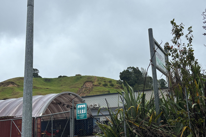
UPDATED: A worker in Tauriko said they were notified of the slip near the SH29 highway about an hour ago.
“Businesses on Whakakake St have been recommended to evacuate. We have been told we might have to, but are waiting for Geotech experts advice,” said the man who works on a neighbouring street.
Fire and Emergency NZ said they were alerted to the landslide behind a building on Whakakake St about 9.41am.
“The building was evacuated and Fire and Emergency had left the incident at 10.37am.”
An orange heavy rain warning remains in place for Bay of Plenty, west of Whakatāne, until 1am tomorrow, MetService said in its 11.30am forecast.
The area can expect 50 to 80 mm of rain on top of what has already fallen with peak rates of 15 to 25 mm/h, or possibly more in localised areas. There is moderate chance of upgrading to a Red Warning.
Bay of Plenty state highway update
Overnight saw heavy rain fall and strong winds.
With rain forecast to continue throughout today, NZTA advised people to delay their travel if possible.
“If you must travel, check the NZTA Journey Planner for the latest updates, drive to the conditions and be prepared as there may be flooding, fallen trees or slips on your journey. “
Tauranga:
SH2 south of Katikati – OPEN, drive with care.
SH2 between Wairoa Bridge and Clarke Road – OPEN, shoulder closure on left heading to Te Puna. Cycle path closed at Wairoa Bridge due to slip.
SH2 between Bethlehem and Waihī overbridge (Takitimu Drive) – OPEN, surface flooding – drive with care.
SH29A between Oropi roundabout and Barkes Corner – CLOSEDuntil water recedes.
Eastern Bay of Plenty:
SH2 Matatā straights – CLOSED, flooding Ōtamarākau.
SH2 Otamarakau – CLOSED, due to surface flooding.
Rivers at warning levels
The Kaituna and Paraiti Rivers have reached first warning levels, according to the Bay of Plenty Regional Council.
This means the river level has reached its normal channel capacity.
A spokesperson said the council’s Flood Room was on active watch.
“We are providing real-time information and data to supporting agencies, such as local councils and Waka Kotahi, to assist with their planning and responding to their communities.
“Our operations team on the ground are out checking flood defences, including stopbanks, floodgates, pump stations and drains and will continue to monitor and respond to the impact of significant rainfall across the Bay of Plenty.”
Wet weather to continue
MetService meteorologist Mmathapelo Makgabutlane said there had been “quite a spread” of rain in the Bay of Plenty with rainfall ranging between 100mm and 190 mm.
She said Tauranga had measured 122mm of rainfall in the last 24 hours, 63mm since midnight.
The “highest spots” in the region were recorded from a station on Matakana, which measured 194mm in the last 24 hours, and Te Puke with 154mm, Makgabutlane said.
“We’re still expecting wet conditions for the rest of today. An orange warning goes until tomorrow morning.
“The first real easing that we can expect only comes in during the second half of Saturday, until then, there will still be some showers, with the heavier portion being today.”
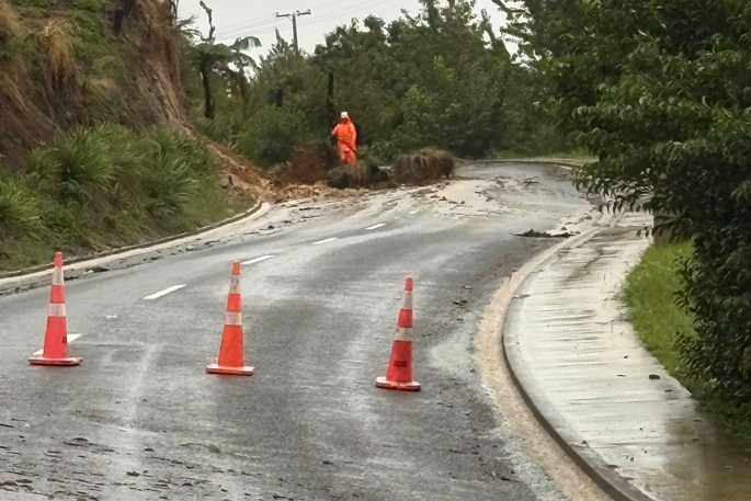
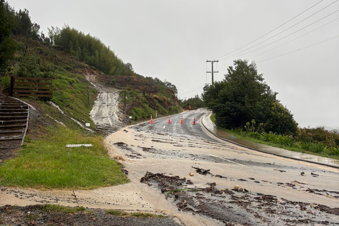
Slip in Te Puna
A Te Puna resident has reported a slip on Plummers Point Rd.
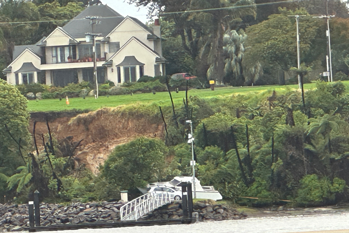
She said a slip had come down on top of a boat, which had been pulled ashore a couple of days ago.
She said the photo taken was from the Waitui Reserve.
“I also tried to head to the shops but there was like a river on Armstrong Rd. It was swiftly flowing. There were two other cars, as well as me, that had to turn around.”
Western Bay District Council update
The council says it has received more than 300 service requests this morning.
Road closures and flooding:
7.38am – Car crash on the Eastern Link Toll Rd towards Paengaroa, following a car crash. Lanes in that direction are currently blocked. Expect delays.
8am – Due to flooding, the low-lying area up Waitao Rd around the Waitao Bridge is closed.
Browns Drive in Waihi Beach is closed both lanes due to flooding.
Seaforth Rd, Bowentown end, closed due to flooding.
8am – Surface flooding out at Katikati area and Waihi Beach.
Flooding on Albacore Ave – reportedly 4 inches deep.
Shaw Road flooding – knee-deep surface flooding.
Wastewater overflow at Athenree and Roretana pumpstation.
Stay out of floodwaters as it may be contaminated
Closed – Minden Rd due to flooding.
Confirmed closed due to flooding – Waihi Rd to Bethlehem Rd.
Te Matai Rd – Multiple areas of flooding from 1492 Te Matai Rd.
Road closed at SH2 and Maleme St due to flooding.
Quarry Rd heading towards Manoeka flooded – can’t get through.
Fallen tree covering Allport Rd.
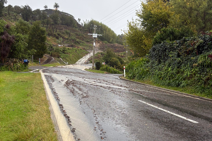
Slip on Mathers Rd – Contractor (JPL) attending. Likely to be closed.
Crawford Rd closed – Police are turning cars around.
Slip at the top of No 3 Rd just past the bridge on the gravel. Whole road is blocked.
Wairoa River is currently at high tide level.
Harbour View Rd in Waihi Beach– closed between 17-19 HV Rd slip across the road. Roading crew is going out there to manage the slip material across the road.
Road closed at 182 Crawford Rd due to underslip. Slip has gone down and affected a implements shed. Very restricted for residents in and around that area. Spray Marks are on there way to do stop go. Police are there currently. Roading crew will get up there to inspect it and clear it.
Community hubs:
Waihi Beach RSA open
Ōmokoroa Pavillion
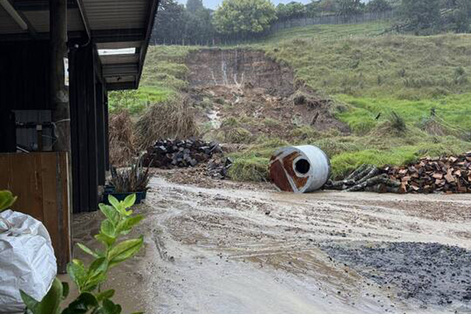 A slip on Crawford Rd in the Western Bay of Plenty. Photo / Supplied
Crawford Road in Minden, Western Bay of Plenty, has been closed by a large slip.
The slip was reported at 8am, between Vernon Rd and Junction Rd, police said.
“No injuries have been reported and no evacuations are needed, but motorists are urged to take alternative routes.
“For residents in the Minden area, Poripori Rd is open.”
Police said motorists across the Bay of Plenty district are urged to drive with care and allow additional time to travel.
 A slip in Minden. Photos / Supplied

Roading update
State Highway 29 between Ōropi Rd and Barkes Corner will be closed until water recedes, an NZTA spokeswoman said.
There has been a small slip at the shoulder of SH2 between the Wairoa bridge and Clarke Rd (heading to Te Puna).
The spokesperson said crews were on their way to put a shoulder closure in place.
Tauranga City Council said Maleme St in Greerton was closed by flooding.
“We have contractors on site assessing the situation, and we urge drivers to avoid the area if they can.”
There was also flooding on Burrows St, but it had not been closed.
Flooding on Maleme St in Tauranga. pic.twitter.com/ZcF6OGcrTZ
— Bay of Plenty Times (@Bay_Times) March 26, 2026
“Road conditions can change rapidly, people should be prepared for roads to remain closed or for further closures at short notice. We have crews on the network checking conditions to respond to impacts.
“With rain forecast to continue today, people are encouraged to delay their travel if possible. If they must travel, check the NZTA Journey Planner for the latest updates, drive to the conditions and be prepared as there may be flooding, fallen trees or slips on their journey.”
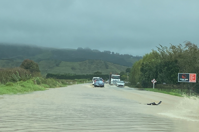
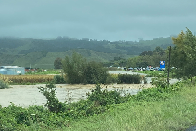
Te Puke flooding
Te Puke resident Peter Willis told the Bay of Plenty Times there was “major flooding” between Raymond Ave and Muir Place.
“Water is just pouring down from the top of the sub bridge and meeting with the river, it’s causing this major flooding.”
He said neighbours were packing bags ready to evacuate, and that his paddocks were also flooded.
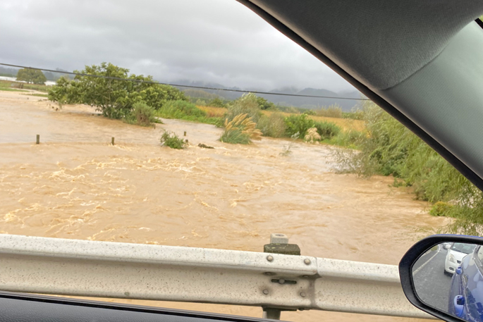
Wairoa Bridge flooding
Flooding has been reported near the Wairoa Bridge on SH2.
A reporter said police said they weren’t aware of any crashes in this location.
“They also said the Wairoa Bridge slip was underneath the bridge.”
Council to monitor “Kaimai Buster”
Waikato Regional Council has activated its flood room.
It said areas west of the Kaimai Range were forecast to be impacted by gale east to northeast winds, likely to produce favourable conditions for what’s colloquially known as the “Kaimai Buster”.
The Buster occurs when the aerodynamic effect of the Kaimai Range turns strong easterlies into gales, a person would struggle to remain upright in and can be strong enough to topple high-sided vehicles, down powerlines, and lift roofs from buildings, the council said.
Strong north to northeast winds forecast in southern parts of the region may also approach severe gale force in exposed places.
Western Bay of Plenty update
Western Bay District Council says it has received over 300 weather-related service requests this morning.
 Flooding in Te Puke. Photos / Supplied
Road closures and flooding:
7:38am – Car crash on the Eastern Link Toll Road towards Paengaroa, following a car crash. Lanes in that direction are currently blocked. Expect delays.
8am – Due to flooding, the low-lying area up Waitao Road around the Waitao Bridge is closed
Browns Drive in Waihi Beach is closed both lanes due to flooding
Seaforth Road, Bowentown end, closed due to flooding
8am – Surface flooding out at Katikati area and Waihi Beach.
Wastewater overflow at Athenree and Roretana pump station.
Stay out of floodwaters as it may be contaminated
Closed Minden Road due to flooding – not sure extent
Community hubs:
Please report any signs of flooding, slips, fallen trees or anything dangerous via Antenno. We recommend only travelling if necessary.