
 SnowBrains New Zealand Winter Forecast 2026. | Image: Weatherbell
New Zealand Winter Forecast 2026: The Seasonal Overview
The SnowBrains New Zealand winter forecast 2026 points to a transition season, with ENSO-neutral conditions at the surface giving way to a developing El Niño signal that is expected to strengthen through the heart of winter. The tropical Pacific is now sitting in ENSO-neutral territory at the surface, warm subsurface water has built across the equatorial Pacific, and the broader signal increasingly favors El Niño emerging during winter. The strongest El Niño signal still looks more likely later in 2026 than at winter’s opening, so June behaves more like a bridge month than a fully mature event. For skiers, that matters more than the label itself, given wind direction and storm track. The pattern points to a mixed opening stretch, followed by a better chance of colder south-to-southwest flow through the heart of the season.
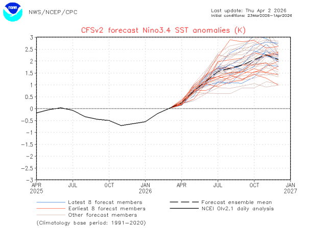 Models are confident that El Niño will return throughout the New Zealand winter. | Image: NOAA
As of early April, the atmosphere still looks untidy. Some weak La Niña fingerprints are hanging on in pressure and trade-wind behavior, yet westerly wind anomalies have pushed into the central equatorial Pacific, and the trade winds have eased. The Southern Annular Mode and Indian Ocean Dipole are both near neutral right now, which leaves June without a clean, locked-in regime this far out. The winter signal is there, but it probably takes a little time to organize.
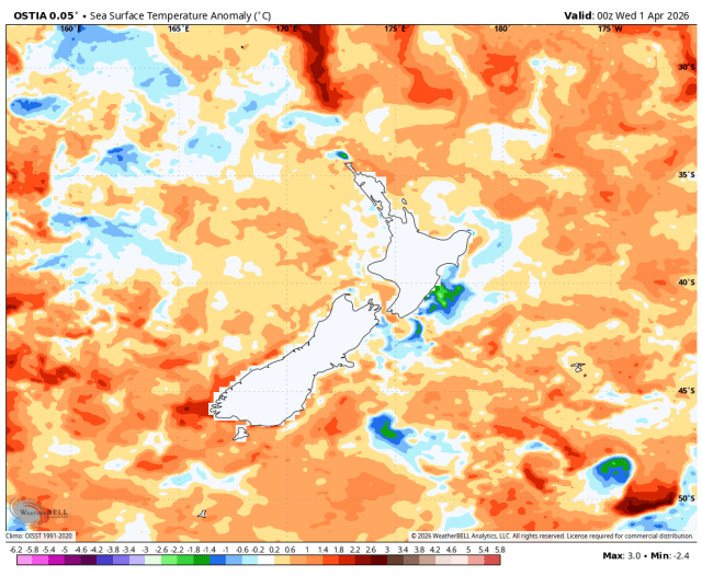 Unfortunately, sea surface temperatures around New Zealand are running far above average. | Image: WeatherBell
The ocean around New Zealand adds an important wrinkle. Waters around the South Island were already running warmer than average at the end of March, especially off the west coast at +0.78°C and the east coast at +0.40°C, and they are forecast to keep warming through April to June, particularly east of the island. The western Tasman Sea is also forecast to run much warmer than average. Warm water adds moisture to passing systems, which can help snowfall totals when the air mass is cold enough, and it also nudges marginal snow levels upward early in the season, especially on lower slopes and during warm-sector events.
That combination supports a clear seasonal arc: early in the outlook period, easterly-quarter flow anomalies are favored. Later, the flow tilts southeasterly, then increasingly southwesterly, as El Niño-like conditions begin to emerge. Historically, New Zealand winters during El Niño are colder because southerly flow becomes more common. For the ski season, that progression supports a variable, sometimes marginal start, followed by a stronger cold-snow preservation signal deeper into July and August.
Keep scrolling for regional forecasts…
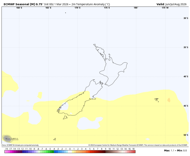 Long-range models favor average to above-average temperatures. | Image: WeatherBell
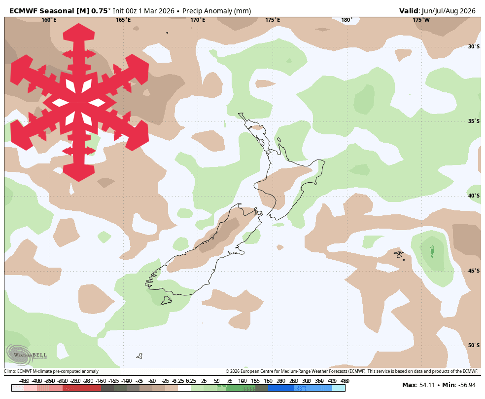
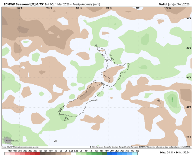 Long-range models favor slightly below-average precipitation. | Image: WeatherBell
Long-range models favor slightly below-average precipitation. Credit: WeatherBell
Ruapehu — Volatile but Near-Average
Ruapehu carries the most volatility this winter. The central North Island is favored for near-average temperatures and near-normal to slightly above normal rainfall through June, and the North Island remains more exposed to early-season subtropical moisture before the cleaner southerly signal matures. On Ruapehu, snowfall depends heavily on freezing level, wind direction, and how quickly cold air arrives behind each system. That setup supports a choppy first half of winter, then a more productive window from late July into August as southerly influence grows. Overall, near-average natural snowfall is the central outcome, with bigger swings in surface quality and operating windows than the South Island.
Canterbury and Mackenzie — The Best Bet of 2026
This is the zone we like best. The east of the South Island carries a broadly near-normal rainfall signal with near-average temperatures, while current guidance also notes that onshore flows can suppress daytime temperatures in eastern regions. Plain westerly flow can be a mixed-snow producer east of the divide because the Alps wring out a lot of moisture before it reaches the leeside. The colder southeasterly and southwesterly changes behind those systems often do the real snow-building. That matters for the Mt Hutt zone, the Canterbury club fields, and the higher Mackenzie terrain, because these areas are well placed when those colder changes line up. As winter matures, the developing southwest bias should help the higher South Island fields build and hold snow more efficiently. We lean toward near-average to slightly above-average season quality here, with the best stretch centered on midwinter.
Wānaka, Queenstown, and Inland Otago — Intermittent but Quality
The southern lakes look more intermittent. Inland Otago sits within a region tilted toward near-normal to below-normal rainfall through early winter, and Central Otago has entered April with abnormally dry conditions. That region also sits deeper in the lee of the divide during many westerly regimes, so longer dry windows are plausible between storm cycles. Strong snow cycles remain very possible, and they are likely to be spaced farther apart. The Wānaka and Queenstown fields should still cash in when proper southwest or southerly systems arrive, and snow quality could be very good after colder outbreaks. Consistency looks a little weaker here than in Canterbury, especially early, so near-average season totals feel like the right call. Quality may outrun quantity at times.
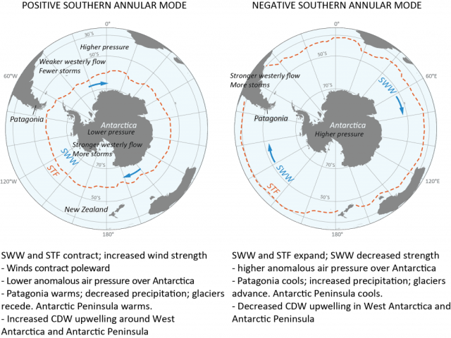 Negative SAM episodes improve snow chances for New Zealand. Credit: Antarctic Glaciers
The New Zealand Winter Forecast 2026 Wildcard: The Southern Annular Mode
The biggest wildcard is the Southern Annular Mode. When SAM turns negative, storm tracks and westerlies tend to shift farther north toward New Zealand, and unsettled weather increases. When it turns positive, pressure rises over New Zealand, and the weather calms down. SAM can change rapidly on weekly timescales, which keeps exact storm timing low confidence even when the seasonal background looks favorable. That matters in New Zealand more than people sometimes realize, because ENSO explains less than a quarter of the year-to-year variance in seasonal rainfall and temperatures at most locations. The broad pattern matters, and the week-to-week details still decide the ski season.
The SnowBrains call is straightforward: expect a winter that starts unevenly, strengthens through midseason, and gives the best relative odds to Canterbury, Mackenzie, and the higher South Island fields. Ruapehu looks serviceable and volatile. The southern lakes should have some solid windows, with snowfall arriving in bursts. Confidence is moderate on the seasonal arc and lower on exact snowfall totals. July and August look primed to do the heavy lifting.