
Heavy rain is falling in Whangārei, and there have been evacuations in Kerikeri as Cyclone Vaianu gets closer.
The Kaipara District Council is also urging people living in flood-prone properties to prepare an evacuation plan before it’s needed.
Further north, Northland Civil Defence has confirmed a number of people were evacuated from their homes in central Kerikeri earlier this evening amid fears large trees could come down when Cyclone Vaianu hits later tonight.
Tauranga mayor Mahe Drysdale has declared a state of emergency ahead of Cyclone Vaianu.
Drysdale said this will allow the council to keep people safe during worsening weather conditions.
He said the council had been preparing for the last few days.
“We’ve been going around the city doing what we can to prepare for the weather event. And now we’ve just declared a state of emergency.
“We are as prepared as we possibly can be with an event like this coming.”
Further down the coast, mandatory evacuations have been extended in parts of Ōhope and Thornton as Cyclone Vaianu strengthens, with residents in other low-lying areas urged to leave now as Cyclone Vaianu makes its way towards the North Island.
Whakatāne District Council Acting Mayor Julie Jukes said the risk to life was real.
“This is a dangerous weather event. There is a real risk to life, particularly in coastal and low-lying areas. Our message is clear: if you are told to leave, you must leave.”
Residents in mandatory evacuation zones have been told to be out by this evening, with more evacuations possible.
In the Coromandel, a brown swell and whitecaps are rolling in along the Coromandel Coast.
In Whitianga, locals say they are well prepared, especially given the number of weather events they have faced just this year alone.
The town is deserted, and the roads are mostly empty with supermarkets saying they are quiet today after mad preparations earlier in the week.
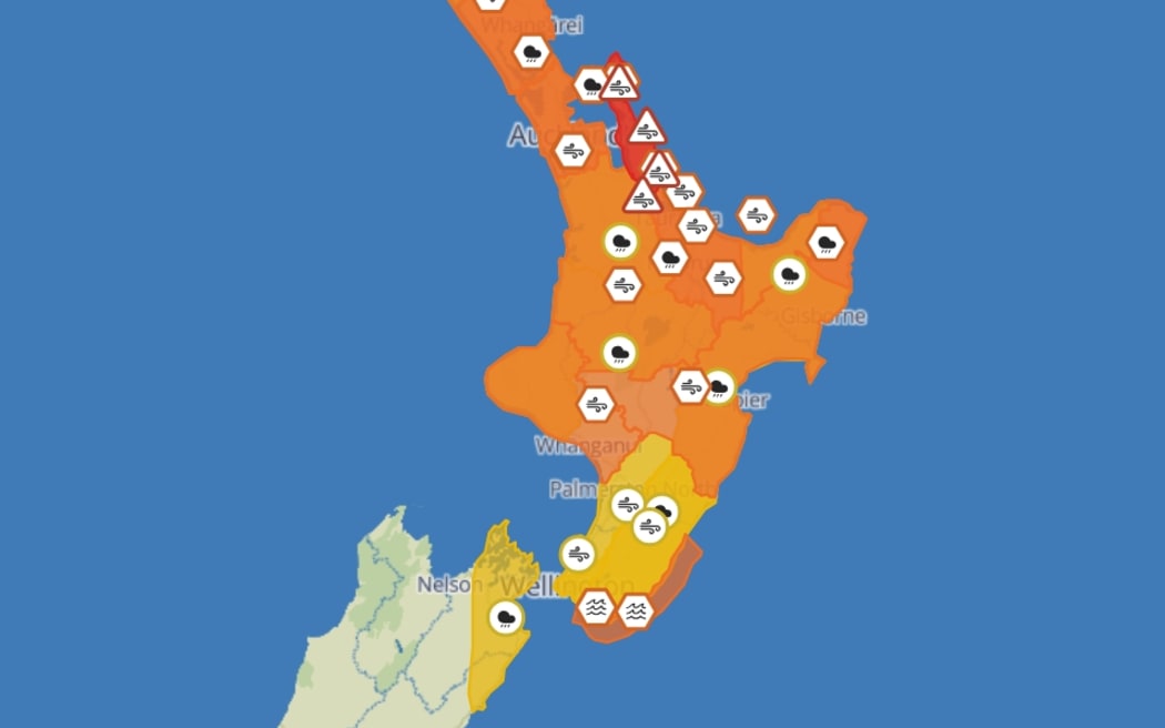
An orange heavy rain warning is in place for Northland and parts of Bay of Islands from Saturday night.
Local states of emergency have been declared in Whakatāne, Hawke’s Bay and Waikato.
Aucklanders recieved an emergency notification via their phones shortly before 2pm.
Coromandel Peninsula is under a red strong wind warning and orange heavy rain warning from the early hours of Sunday morning.
Northland and south of Bay of Islands to Hokianga Harbour, Auckland and Great Barrier Island are under orange heavy rain warnings from Saturday night.
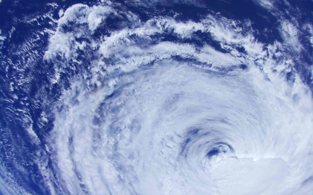
Cyclone Vaianu, as it tracked south from Fiji, as captured by TPA-1, Aotearoa’s only satellite.
Photo: Supplied / Te Pūnaha Ātea / The University of Auckland
An orange heavy rain warning will be in place from the early hours of Sunday in the Coromandel Peninsula, Bay of Plenty west of Whakatane including Rotorua and Gisborne/Tairawhiti north of Tolaga Bay.
Earlier this week, MetService warned the combination of damaging winds, heavy rain and coastal inundation makes this a multi-hazard, potentially life-threatening event.
There were concerns for power outages, falling trees, flooding, slips and potential road closures that could isolate communities.
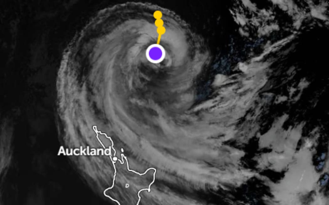
Satellite imagery and the projected track of Cyclone Vaianu as it closes in on New Zealand.
Photo: Zoom Earth
The forecaster urged people to keep up to date with the latest forecasts, adjust plans as needed and be prepared to act, following all advice of local authorities.
Heavy rain watches have also been issued. Some areas may be upgraded to orange, or possibly red level warnings as the cyclone approaches and its track becomes clearer.
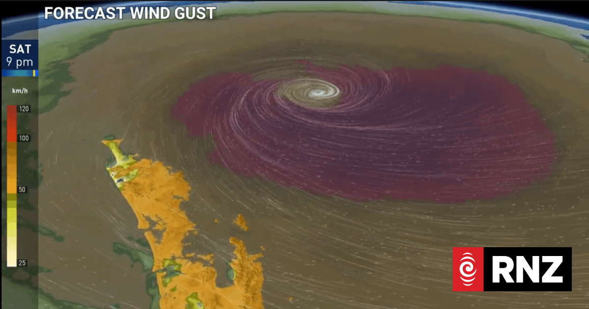
MetService has put the entire North Island under warnings and watches for parts of the weekend.
Photo: MetService/Screenshot