
The Colorado River did not always look like the vast, connected waterway we know today. A new study suggests that before it carved its way into the Grand Canyon and reached the Gulf of California, it spent time pooling in an ancient lake east of the canyon.
That hidden stage may have been the turning point that transformed it into a river capable of linking ecosystems across much of western North America.

The study was led by researchers including UCLA geologist John He. The work helps fill in one of the biggest missing chapters in the Colorado River’s early history.
The study reveals how the river got from western Colorado, where it already existed 11 million years ago, to the Grand Canyon, which it first exited around 5.6 million years ago.
The new evidence suggests the river flowed into what is now known as Bidahochi Lake, in an area on present-day Navajo Nation land, before eventually continuing downstream and reaching the Gulf of California around 5 million years ago.
A long-standing mystery
Researchers have known for years that the river existed in some form in western Colorado millions of years ago and that by about 5.6 million years ago it was flowing out of the Grand Canyon. But what happened in between was much harder to pin down.
That missing stretch of its history mattered because it covered roughly five million years.
Somewhere during that time, the river had to find a way through difficult terrain and become the continental-scale system that later shaped the canyon and carried water all the way to the sea.
“In some ways, you could really think of it as the birth of the Colorado River that we know today,” He said.
“There are rivers everywhere, but a river that carries water and sediment across the continent connects life throughout the region, and the entire ecosystem probably changed as a result of the arrival of the Colorado River into the basin.”
A lake east of the canyon
The new work suggests that before the Colorado River flowed through the Grand Canyon, it emptied into a lake lying just to the east.
That lake, known as Bidahochi Lake, has long been a geological mystery of its own since most of its deposits have eroded away, so scientists do not know exactly how large it once was.
The new study makes a clearer case that the Colorado River was feeding that basin around 6.6 million years ago. If that is right, then the river may have pooled there for a period before eventually spilling out and continuing on its downstream course.
Geologists have proposed many possible explanations for how the Colorado crossed the Kaibab Arch, a high region in northern Arizona and southern Utah that would have stood in its way.
Several processes working together
One theory is lake spillover: the river filled a basin, the lake rose, and water eventually found a route out toward what would become the Grand Canyon.
“Geologists have proposed over a dozen hypotheses for the canyon’s formation and the Colorado River’s path,” said co-author John Douglass, a geologist at Paradise Valley Community College.
“Other processes, such as karst piping, which involves water transport through rock, and headward erosion, may have also contributed to the establishment of the river’s course,” added corresponding author Ryan Crow, from the U.S. Geological Survey.
“Some reaches were likely newly carved, and others would have been significantly deepened by the integrated Colorado River over millions of years.”
So the picture emerging here is not one simple moment when everything suddenly fell into place. It is more likely a story of several processes working together, with lake spillover playing a key role.
Tiny crystals, big clues
The breakthrough came from sandstone and the microscopic minerals hidden inside it. The researchers began by studying remnant deposits of Bidahochi Lake in the field to clarify where the sediments in that ancient lake come from.
To answer that, He turned to zircons, tiny crystals found in sediment that act a bit like geological timestamps.
Because zircons form in cooling magma and hold onto their chemical signatures over immense periods of time, they can reveal where sediment originally came from.
Geologists use a method called detrital zircon geochronology to study them. By measuring uranium and lead isotopes in hundreds of zircon grains from a sample, researchers can estimate the ages of those crystals and match them to known source rocks.
The overall pattern, known as a detrital signature, can then be used to trace the history of a sediment deposit.
“Zircons are some of the oldest fragments of our Earth,” said He. “They’re like little time vaults, and by looking at the age and geochemical signature of zircons, we can tell where a sediment that has been moved by a river originated.”
When He analyzed the samples from Bidahochi Lake, he found something surprising. Their zircon signature closely resembled that of sediments already known to have been carried by the ancestral Colorado River.
The river’s connection to the lake
The team compared thousands of zircons from the Bidahochi sandstones with zircons from other known Colorado River deposits, both upstream and downstream.
Sediments laid down in Bidahochi Lake around 6.6 million years ago closely resembled deposits from places like the Browns Park Formation in Utah and Colorado, which are tied to the ancestral Colorado River.
Moreover, rock layers from the same period showed ripples left by a strong river entering standing water. Fossils of large fish associated with fast-flowing rivers were also found there.
Taken together, those lines of evidence point to the same conclusion: the Colorado River was already feeding water and sediment into the Bidahochi basin before it finally spilled over and began flowing through the Grand Canyon.
That overflow, in turn, helped set the stage for the powerful river system that would go on to deepen much of the canyon and eventually reach the Gulf of California.
Reading a half-hidden history
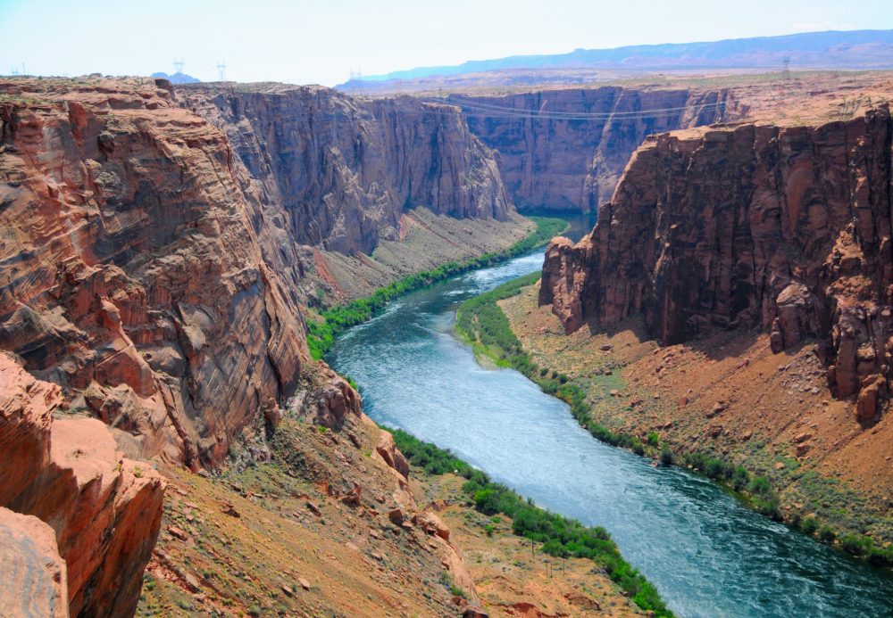
The Grand Canyon is one of the most famous landscapes on Earth, but its history is still being worked out piece by piece.
Geologists have long debated exactly when the canyon formed and how much of it the Colorado River carved. This new study does not settle every argument, but it does make the story more complete.
“I think there is something unique and disquieting when the planet’s history is laid out before our eyes, but we cannot fully read it. We’ve always known the Grand Canyon is there, this solid towering wall of rock, but we’re learning more each day how it formed,” He said.
Yet, although the canyon has always seemed permanent, the river that helped shape it had a far messier beginning than the finished landscape suggests. And only now, grain by grain, is that story coming back into view.
—–
Like what you read? Subscribe to our newsletter for engaging articles, exclusive content, and the latest updates.
Check us out on EarthSnap, a free app brought to you by Eric Ralls and Earth.com.
—–