
Heavy rain fell across the region overnight, with severe thunderstorms striking coastal areas south of Cape Kidnappers.
Several roads have been closed in Central Hawke’s Bay, and the district council was advising people to stay away from beaches and river mouths and avoid streams and drains on Tuesday morning.
In a social media update on Tuesday morning, Central Hawke’s Bay District Council said high tide was due at 8.20am, and king tides were being experienced.
Coastal areas, particularly in Omakere and parts of Elsthorpe, suffered “wild weather” according to the council update.
A webcam view of Pourerere Beach at 8.30am on Tuesday morning.
On Tuesday morning, Pourerere Rd, approximately 20km past Omakere Hall Rd, and Elsthorpe Rd, approximately 15km past St Lawrence Rd had closed.
At 8.44am Herrick Slab Rd was closed due to flooding and Farm Road had closed due to a tree blocking the road.
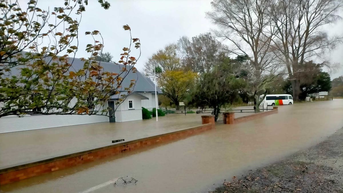
The Omakere Hall was also pictured surrounded by floodwaters.
Hawke’s Bay Regional Council’s telemetered rainfall figures said 95mm of rain had been recorded at Omakere from midnight to 9am on Tuesday.
Flooding at the Omakere Hall in Central Hawke’s Bay at 9am on Tuesday. Photo / Central Hawke’s Bay District Council
A police spokeswoman said police were called about 6.30am with a report of large flooding on State Highway 2, near Ōtāne.
The northbound lane was blocked, and police were stood down as a resident cleared the drain. The road was clear about 7.10am.
The council said there had also been reports of debris on Pourerere Beach Rd.
“Our teams are out across the network assessing and clearing the roads.
Elsthorpe Rd in Central Hawke’s Bay on Tuesday morning just before 9am. Photo / Central Hawke’s Bay District Council
“Beware of fallen trees and power lines, avoid streams and drains as you may be swept away in flash flooding.
“Please drive carefully and call us on 06 857 8060 if you see any debris or trees on the roads.”
A Hawke’s Bay Regional Council spokesperson said on Facebook they were monitoring conditions related to the orange heavy rain warning south of Tūtira.
“Overnight there was some heavy rain in Central Hawke’s Bay, with reports of surface flooding and high levels in the smaller side streams.
“Our flood forecasting suggests the rainfall and runoff will fill the main rivers approximately to the top of bank, but should not cause issues beyond riverbanks.”
Tararua District
A heavy rain warning, which included all of the Tararua District, is now in place until midnight Wednesday.
This had been extended from Monday’s heavy rain warning issued from 6pm through to midnight Tuesday.
People were being told to expect a further 70 to 110mm to accumulate on top of what had already fallen on Monday, but 150 to 200mm about the ranges and coastal hills.
Overnight, Manawatū-Whanganui Emergency Management Group monitored rainfall and staffed a Group Emergency Coordination Centre overnight.
In a 1.26am update, the group said the weather was “quite volatile and unpredictable”.
People in Herbertville reported rain, thunder and lightning storms in the area.
Ākitio in the Tararua District at 9.16am on Tuesday. Photo / Horizons Regional Council webcam
Heavy rain to the east of the Tararua District was coming in batches of heavy falls, which was causing rivers and streams to rise suddenly.
High tide was forecast for about 7.30am today.
According to Horizons Regional Council‘s environmental data monitoring network at 7am, the Ākitio River at Cadmus Bridge had 150mm of rain since 1pm Monday, Wainui River at Wimbledon had 100.2mm, Owahanga River at Owahanga Station had 114.4mm.
Heavy rain was expected to continue to fall in the Tararua District and surrounding area for the next 24 hours, including on the Tararua and Ruahine Range.