
Reading Time: 3 minutes

Low-pressure zones with rain are continuing to form to our north, east, west and south as a messy weather pattern continues in our part of the world. At the same time, high-pressure zones are quite large at the moment and continue to mostly track along the southern coastline of Australia and towards New Zealand.
When I say “quite large”, I mean most of them are about the size of Australia … and you can fit almost 29 New Zealands into that Australia footprint.
These large highs influence our weather – they often decide what wind direction we’re having and how long for, they control the movement of lows and therefore rain, and they bring us our frostiest and foggiest weather.
Low pressure doesn’t move through high pressure; it prefers the path of least resistance and is often guided around them – or can be blocked by them, usually leading to the low falling apart.
During mid to late winter and early spring it’s quite common to see our largest and most powerful highs moving through. One big reason for the wet weather of recent weeks is the gaps in between the highs, allowing for rain and showers to move through New Zealand.
If the highs start joining together more it will seal off some of the chances for lows to move through the NZ area, leading to drier conditions. This is something forecasters will be monitoring closely in the months ahead as El Niño continues to gain strength.
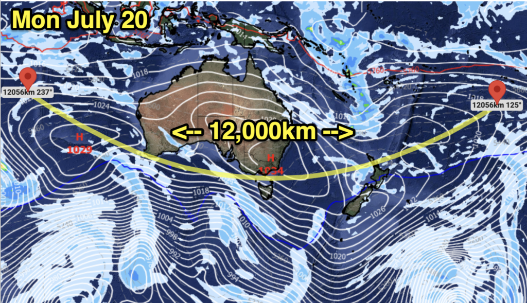 This week starts with a lot more high pressure around NZ and Australia, limiting severe weather and rainfall for a time. Photo: WeatherWatch.co.nz
This week starts with colder air being ushered into NZ thanks to a high parked over eastern Australia. This high then links up with another high-pressure centre offshore from Perth, and a weaker high northeast of NZ – creating a belt of high pressure that stretches 12,000km from west to east.
There is a subtropical area of low pressure trying to head southwards towards us, but that low is likely to be blocked by this high.
As we go through this week, modelling suggests this high-pressure belt does weaken a bit over NZ, dragging in cloud and showers at times.
This weekend there should be a break in that high pressure, ushering in unsettled weather (although modelling was a bit changeable on exactly how this will pan out). One fairly reliable forecasting model picks a low to develop in the NZ area and another low south of Australia.
But the uptick in high pressure, while a good balancing act following recent downpours around NZ, may be of concern if it continues to get larger and more stubborn in the months ahead.
For now, there are still some gaps in the highs bringing in unsettled weather for us and until that changes there isn’t too much concern yet about a significant drying-out phase setting in.
In Australia, rainfall across large parts of the nation has become more subdued, with the bulk of wet weather in coastal areas in the south and east of the nation.
As for El Niño, as you know it’s officially here – but it is still getting stronger. It’s expected to continue getting stronger over the next four months before likely levelling out in summer. It will likely take a number of months in 2027 to weaken.
According to Australia’s Bureau of Meteorology, forecasts are still pointing towards a strong to very strong El Niño event, based on the extent of warming in the central tropical Pacific. The majority of global models indicate this event could peak at levels among the highest observed since 1950.