
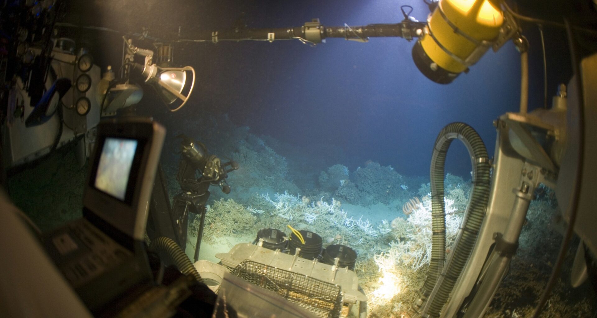
The global body tasked with regulating deep-sea mining ended its July 2026 Kingston session this week with no Mining Code adopted, no commercial mining approved, and its own Legal and Technical Commission citing a critical absence: the baseline environmental science needed to set safe extraction thresholds does not yet exist. That gap is precisely why NOAA’s research vessel Okeanos Explorer is currently in the South Pacific, deploying robotic vehicles into the Cook Islands’ least-explored deep-ocean terrain — and streaming every dive live, free, to anyone with an internet connection.
The ISA’s July 2026 Council session concluded July 28 without a framework for the second time in 2026, following a March session that similarly stalled. The July session’s collapse exposed disagreements spanning environmental safeguards, liability frameworks, inspection protocols, and benefit-sharing — but the LTC’s own finding cut to the structural core: the science underpinning any credible threshold does not yet exist. Meanwhile, aboard the Okeanos Explorer, ROV dive operations are actively generating the kind of baseline habitat and biological data that regulators say they need.
The 2026 Cook Islands ROV Exploration, designated EX2605, is a 26-day cruise underway July 19 through August 13. NOAA Ocean Exploration is conducting it in partnership with the Cook Islands Seabed Minerals Authority, the U.S. Geological Survey, the U.S. Department of State, and the Ocean Exploration Cooperative Institute. The expedition’s stated purpose is to map, explore, and characterize ecologically and economically important unexplored deep-water regions of the Cook Islands — and to do so transparently, with all collected data to be shared with the Cook Islands government and filed in NOAA’s public archives.
Why the Cook Islands Matter
The Cook Islands is a self-governing nation of 15 islands in the South Pacific, with a population of roughly 17,000. What it may lack in land area it more than compensates with ocean: its exclusive economic zone encompasses nearly 2 million square kilometers — approximately 770,000 square miles — of Pacific waters. The average depth within that zone is 5,000 meters (3.1 miles), and in the majority of locations water depth exceeds 2,500 meters (1.6 miles).
Those waters sit above one of the world’s most significant deposits of polymetallic nodules. The Cook Islands Seabed Minerals Authority estimates that approximately 6.7 billion metric tons of nodules lie within the EEZ — formations rich in cobalt, nickel, manganese, copper, and rare earth elements critical to electric vehicle batteries and clean energy infrastructure. Critically for governance: under the UN Convention on the Law of the Sea, these deposits lie entirely within national EEZ jurisdiction, not in the international seabed area governed by the ISA. The Cook Islands government has full sovereign decision-making authority over them — authority that no international body holds a veto over. The baseline science EX2605 is collecting will feed directly into a sovereign national decision, not an international one.
The Cook Islands has developed what CIC Ocean Research describes as “the world’s most advanced legal regime governing seabed minerals,” with three active exploration licenses covering portions of the EEZ. Those licenses are currently in the exploration phase; no commercial extraction has been authorized. The EX2605 expedition does not authorize commercial mining and does not replace Cook Islands law, public process, or environmental safeguards.
The ROV System: How EX2605 Dives
At the center of the expedition’s data-collection capability are two tethered robotic vehicles operated in tandem: ROV Deep Discoverer, known as D2, and its companion camera sled, Seirios.
D2 is rated to 3.7 miles (6,000 meters) depth — the operational limit of current fiber-optic-tethered ROV systems. It weighs 9,700 pounds (4,400 kilograms), carries 27 LED lights, nine video cameras, and manipulator arms capable of collecting biological and geological samples. Its primary camera can zoom in on an organism as small as 3 inches (7.6 centimeters) at a distance of 10 feet (3 meters). Sensors on board measure salinity, temperature, depth, and dissolved oxygen. D2 ascends and descends at 98 feet (30 meters) per minute.
Seirios rides directly below the ship on a steel tether of approximately six miles. It connects to D2 via a shorter yellow tether beneath it, absorbing the heave and surge of the ship’s motion at the surface so that D2 can traverse the seafloor without being destabilized by waves above. Seirios carries wide-angle cameras that provide pilots and scientists with context-level footage; D2 provides the close-up detail.
The data pathway from ROV to living room runs through several stages: video and data travel from D2 to Seirios via tether, then up the fiber-optic umbilical to the ship, then via satellite link to NOAA’s shore-based science hub, and from there to a live web broadcast accessible at oceanexplorer.noaa.gov and on NOAA Ocean Exploration’s YouTube channel. Shore-based scientists watch in real time and radio guidance back to pilots on the ship, a model known as telepresence — it allows researchers anywhere in the world to participate actively in dive science without leaving the shore.
The fiber-optic tether is both the enabling and limiting technology of this system. It provides the bandwidth for high-definition live video — but the engineering constraints of cable design and pressure housing mean that current ROVs cannot go reliably deeper than 6,000 meters (3.7 miles). At that depth, the vehicle already operates at roughly 600 times the atmospheric pressure at the surface. The next generation of deep-ocean exploration will require fundamentally different communication technology — acoustic, optical, or hybrid systems — to reach the abyssal trenches that lie beyond D2’s current reach.
For EX2605 in 2026, the team is also operating with updated field capabilities: new transect cameras, laser systems for in-situ size measurement, and push cores for extracting undisturbed seafloor samples. Two red laser dots, spaced precisely 10 centimeters apart, allow scientists to determine the size of organisms they observe on the seafloor without physically touching them.
What the Robots Are Seeing
During ROV dives into the South Penrhyn Basin and along the Manihiki Plateau — two distinct geological environments within the Cook Islands EEZ — the expedition’s cameras have been imaging a seafloor covered with the polymetallic nodules that have drawn international attention: roughly potato-sized, slightly flattened spheres of iron and manganese hydroxides, resting unburied and unanchored on the sediment surface. They range from grape-sized to potato-sized, with most approximating the dimensions of a golf ball.
Nodules form through one of Earth’s slowest geological processes: they accrete layer by layer from manganese and iron oxides in seawater, growing around a nucleus — typically a shark tooth, a fragment of shell, or a piece of volcanic rock. The growth rate is less than 4 millimeters per million years. That number is central to any governance discussion: it means that if the nodules are removed by commercial collection, they will not regenerate on any timescale meaningful to human civilization. Any decision to extract them is, for all practical purposes, permanent.
Beyond the nodules themselves, the expedition is imaging the biological communities that have evolved around and between them: sponges, corals, sea cucumbers, holothurians, and rare organisms adapted to a dark, cold, high-pressure environment that has received almost no scientific attention. Cook Islands waters at these depths are largely unexplored — the expedition is producing the first systematic biological and geological baseline for regions that have never been directly observed.
EX2605 is also operating four sonar systems aboard Okeanos Explorer around the clock: multibeam, sub-bottom, water column, and side-scan. Seafloor mapping runs overnight while ROV operations take place during the day, allowing the ship to build high-resolution charts of the terrain that inform the next day’s dive targeting.
The Environmental Baseline Problem
A 2025 study published in Nature Ecology and Evolution provided the most rigorous quantification to date of the harm from commercial-scale deep-sea nodule collection trials: macrofaunal density in mined areas decreased by 37 percent, and species richness decreased by 32 percent compared to undisturbed zones. The study was conducted in the Clarion-Clipperton Zone, the international seabed area that has been the focus of most ISA-regulated exploration activity — a region geologically and ecologically distinct from the Cook Islands EEZ, but providing the only available analogues for what commercial collection would do to abyssal habitats.
A 40-year longitudinal study of historic mining disturbance tracks found that macrofaunal communities remained persistently altered in directly disturbed areas decades after the original disturbance, despite some evidence of recolonization. Recovery timescales appear to extend across human generations.
Research by GEOMAR’s MiningImpact project found that sediment plumes from nodule collection can travel far beyond the direct extraction area, extending the zone of potential impact for centuries before settling.
These findings establish what scientists call the baseline problem: because no baseline ecological survey exists for most of the Cook Islands EEZ, it is currently impossible to set credible environmental thresholds for any future extraction activity. You cannot measure a change if you have no documented starting point. The ISA’s LTC made this explicit at the July 2026 session: significant gaps in baseline science are preventing the establishment of reliable environmental thresholds for deep-sea mining. EX2605 exists, in part, to begin filling those gaps.
The Governance Deadlock
The ISA’s 31st Council session, concluded in March 2026 without a Mining Code, set up a July reconvening that was expected to advance the regulatory text. The July session met July 13-24 and was followed by the Assembly from July 27-31. Both sessions ended without a framework, with unresolved issues spanning the full scope of the proposed regulations: environmental safeguards, liability, inspection and compliance mechanisms, and benefit-sharing arrangements.
The governance structure at stake is substantial: the ISA, established under UNCLOS in 1994, is the international body responsible for managing mineral resources in the “Area” — the seabed beyond national jurisdiction, considered the common heritage of humankind by international law. Its 167 member states include virtually every maritime nation. Notably, the United States is not an ISA member, having never ratified UNCLOS. The NOAA-Cook Islands EX2605 partnership operates entirely within the EEZ framework of national jurisdiction — outside ISA purview.
“The science is not there,” Sofia Tsenikli, Global Campaign Director of the Deep Sea Conservation Coalition, said following the session’s conclusion. “The compliance inquiry is ongoing. The regulatory and governance framework remains absent. Unlawful mining attempts continue unchallenged by States and the International Seabed Authority. None of these points towards deep-sea mining. It points towards precaution. It points toward a moratorium.”
Forty-three governments currently support a moratorium or precautionary pause on deep-sea mining pending adequate science and governance frameworks. The DSCC’s legal advisor Duncan Currie said after the July session that governments have spoken about defending the common heritage of humankind, but that words alone will not protect it — states, he said, need to show they are prepared to take action against companies seeking to undermine the international system.
Cook Islands Between Washington and Beijing
The Cook Islands has simultaneously pursued bilateral relationships with both the United States and China on seabed mineral governance — and the two relationships are openly in competition. In February 2025, Cook Islands and China elevated their relationship to a Comprehensive Strategic Partnership, with the Cook Islands Seabed Minerals Authority signing a memorandum with China’s Ministry of Natural Resources covering exploration and resource management within the EEZ. The move surprised New Zealand and reconfigured the regional political dynamic.
Later in 2025, the United States and Cook Islands announced a joint partnership to advance scientific research and responsible development of seabed mineral resources — leading directly to the EX2605 partnership now underway. China subsequently sent the research vessel Da Yang Hao to the Cook Islands in November 2025 as part of its own seabed engagement in the region.
John Parianos, Knowledge Management Director of the Cook Islands Seabed Minerals Authority and a Cruise Science Co-Lead for EX2605’s second leg, has been direct about the Cook Islands’ approach to outside interest. In an April 2026 interview with the Stimson Center, Parianos said: “We will not entertain any shortcuts. Things have got to be done properly.”
That posture — asserting sovereignty and scientific rigor against what both Washington and Beijing are framing as a strategic resource race — is the context within which EX2605 is being conducted. The Cook Islands government has made clear that the expedition does not authorize extraction and does not replace the Cook Islands’ own law, public consultation process, or environmental safeguards.
How to Watch the Dives
Live ROV footage is being streamed most days from July 20 through August 11 at oceanexplorer.noaa.gov/livestreams/ and via NOAA Ocean Exploration’s YouTube channel. Dives take place during daylight hours in Cook Islands time; viewers can watch the ship’s pilots and scientists navigate D2 across the seafloor in real time, with shore-based researchers joining via telepresence to guide observations and sampling decisions.
All data collected during EX2605 — multibeam sonar maps, water column profiles, video footage, biological and geological samples — will be submitted to NOAA’s public data archives within 120 days of the expedition’s conclusion on August 13. The data will be provided to the Cook Islands government and will be freely accessible to researchers, policymakers, and the public through NOAA’s Ocean Exploration Data Atlas.
Whatever the Cook Islands ultimately decides about its seabed mineral future, the footage, maps, and biological records coming off Okeanos Explorer this month will be among the most consequential scientific inputs into that decision — and they will be available to everyone.
Frequently Asked QuestionsWhat is the ISA Mining Code, and why hasn’t it been finalized?
The International Seabed Authority’s Mining Code is the regulatory framework that would govern commercial extraction of mineral resources from the deep seabed in international waters beyond any nation’s jurisdiction. The ISA has been working to finalize it since 2014. As of July 28, 2026, the code remains unfinished — the ISA’s own Legal and Technical Commission has cited significant gaps in the baseline environmental science needed to set credible extraction thresholds, and member states continue to disagree on key provisions including environmental safeguards, liability, inspection mechanisms, and benefit-sharing. The July 2026 Council session ended without a framework for the second time in 2026.
Can anyone watch the NOAA deep-sea dives live?
Yes. Live video from ROV Deep Discoverer and Seirios is being streamed free, with no registration required, most days through August 11 at oceanexplorer.noaa.gov/livestreams/ and on NOAA Ocean Exploration’s YouTube channel. Dives generally take place during daytime hours in the Cook Islands. Dates and times are subject to change based on weather and operational conditions.
What are polymetallic nodules and why do they matter?
Polymetallic nodules are mineral formations that rest loose on the abyssal seafloor, growing over millions of years from manganese and iron oxides in seawater around a small nucleus such as a shark tooth or shell fragment. They accumulate at less than 4 millimeters per million years — meaning removal is functionally permanent on any human timescale. Cook Islands nodules are especially rich in cobalt, nickel, copper, manganese, and rare earth elements, all essential to electric vehicle batteries and clean energy infrastructure. The Cook Islands Seabed Minerals Authority estimates its waters hold approximately 6.7 billion metric tons of these nodules, one of the world’s largest known deposits.
Is deep-sea mining harmful to the environment?
Peer-reviewed research on commercial-scale nodule collection trials indicates significant and persistent harm. A 2025 study in Nature Ecology and Evolution found that macrofaunal density decreased by 37 percent and species richness by 32 percent in areas subject to collection disturbance, compared to undisturbed zones. A separate 40-year longitudinal study found that biological communities in historic mining tracks remained persistently altered decades after disturbance. Research by GEOMAR’s MiningImpact project found that sediment plumes can extend impacts far beyond the collection footprint. A central challenge is that all existing studies were conducted in international seabed areas, not in the Cook Islands EEZ — which is why baseline data from expeditions like EX2605 is considered essential before any governance decisions can be made.
Does the ISA regulate Cook Islands seabed mining?
No. The ISA regulates mineral extraction in international waters beyond any nation’s Exclusive Economic Zone — territory considered the common heritage of humankind. The Cook Islands’ polymetallic nodule deposits lie entirely within its own EEZ, under its sovereign jurisdiction. Under the UN Convention on the Law of the Sea, the Cook Islands has the exclusive right to manage, permit, or prohibit extraction of those resources. The ISA has no authority over them. This means the baseline science EX2605 is gathering will inform a sovereign decision by the Cook Islands government — a decision that the international community has no veto over.