
Police are also asking the public to avoid unnecessary travel in Kaeo and Kawakawa as river levels rise following downpours.
Water levels in Kawakawa were just below the river bridge on Saturday evening, with high tide yet to come, police warned.
Orange warnings are in place for Auckland and Great Barrier Island, Coromandel Peninsula, Bay of Plenty and Tairāwhiti north of Ruatoria, with a low chance of upgrades to red warnings. Heavy rain watches for Northland and Waikato north of Hamilton have been lifted.
MetService meteorologist Katie Lyons said the wet weather was moving southeast as expected, with the heaviest rain now affecting Coromandel and the Bay of Plenty.
Some parts of Coromandel had recorded about 20mm of rain in an hour, similar to rainfall totals seen earlier in Northland, she said.
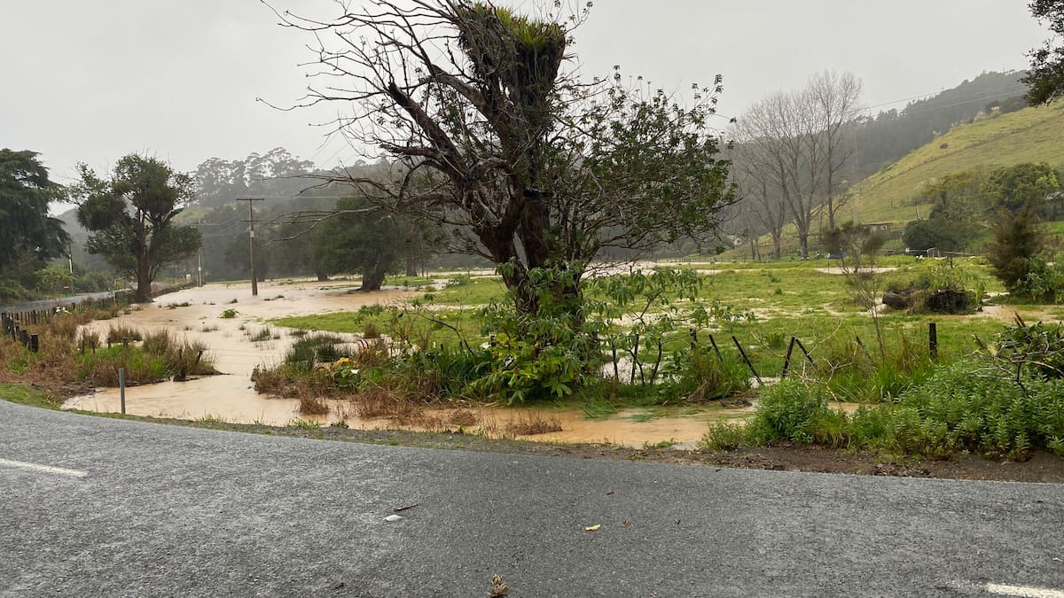
Flooding in Helena Bay, northeast of Whangārei. Photo / Denise Piper
Lyons said the system would continue tracking southeast overnight and move across the East Cape.
“This system is moving southeastwards. That’ll ease into this evening.”
She said localised downpours remained the biggest concern, but wasn’t able to predict exactly where they could strike.
“What might catch people out is the localised downpours. Not everyone will get them, but it is something people need to be aware of.”
Paddocks on Wayby Valley Rd, north of Auckland, starting to flood. Photo / Hayden Woodward
MetService recorded rainfall rates of 25mm/hour in parts of Northland Saturday afternoon. Lyons said rainfall of more than 6-7mm/hour is generally considered heavy.
Thunderstorm warnings could be issued if rainfall rates approached 30mm/hour.
MetService had previously warned the intense downpours could lead to surface flooding, flash flooding and difficult driving conditions.
Auckland Emergency Management activated its flood alert system on the Mahurangi River near Warkworth, warning people to avoid Falls Rd, particularly sections that ford the river or are typically affected by flooding.
Advice posted to Auckland Emergency Management’s Facebook page before the wet weather urged people to take “extreme care if you’re driving in heavy rain, and delay trips if possible”.
It also encouraged people to check their drains and gutters aren’t blocked, and to call 09 301 0101 to report flooding and blocked stormwater drains.
“If your life or property is at risk, phone 111.”
MetService’s rain radar shows heavy rain is expected across the upper North Island at 6pm today.
Those in Coromandel Peninsula, Bay of Plenty and north of Ruatoria have also been warned to expect heavy rain over 17 hours until early Sunday.
Those areas have been told to expect up to 100mm of rain, possibly more in localised areas, with areas east of Whakatāne likely to be the wettest spots in Bay of Plenty.
In the deep south, a strong wind watch remains in force for southern areas of Southland and Clutha for 27 hours from 9am Sunday until noon Monday. Westerly winds could approach severe gale in exposed places, with a moderate chance the watch will be upgraded to a warning.
A strong wind watch has also been issued for Hawke’s Bay south of Hastings and the Tararua District. Westerly winds could approach severe gale in exposed places from Sunday afternoon and are likely to reach severe gale on Monday.
The watch is in force for 30 hours from 3pm Sunday until 9pm Monday and has a high chance of being upgraded to a warning.
MetService said the winds could damage trees, powerlines and unsecured structures, while driving could be difficult for high-sided vehicles and motorcyclists.
Meanwhile, motorists have been warned to expect snow on the Crown Range Rd between Queenstown and Wānaka and Fiordland’s Milford Rd (State Highway 94) tomorrow.
Showers are expected to turn to snow early tomorrow afternoon around the Crown Range summit, with 3cm to 6cm about the summit and lesser amounts to 800m over a 13-hour warning period.
Up to 15cm of snow could be on the way for the summit of Milford Rd (SH94) at Homer Tunnel tomorrow, which may cause disruption for motorists. This photo shows a previous snowfall in 2019.
Up to 15cm, and possibly more, snow could fall at the summit of Milford Rd over 28 hours from 2pm tomorrow. Lesser amounts could be expected to 600m.
A combination of weather systems is behind the wet weekend.
MetService meteorologist Katie Lyons said “some complex weather” was expected this weekend up north, with the front that caused severe conditions in the South Island this week moving up the country.
“We’ve got a low that’s sitting north of Northland and that’s got a couple of features, a couple of rain bands within it – one of which was the front that we saw move over the South Island [on Thursday] and is making its way on to the lower North Island now.
“The other rain band that is associated with this low is approaching from the north … and these two rain bands actually kind of merge over the North Island and create a big swirling mass of rain over the upper North Island.”
Temperatures are set to be slightly warmer than average this weekend, with a few places on the east coast of the North Island cracking the 20s as spring approaches.
It’ll be 21C and partly cloudy in Napier tomorrow, and the rain should clear early in Gisborne, where a high of 20C is forecast.