
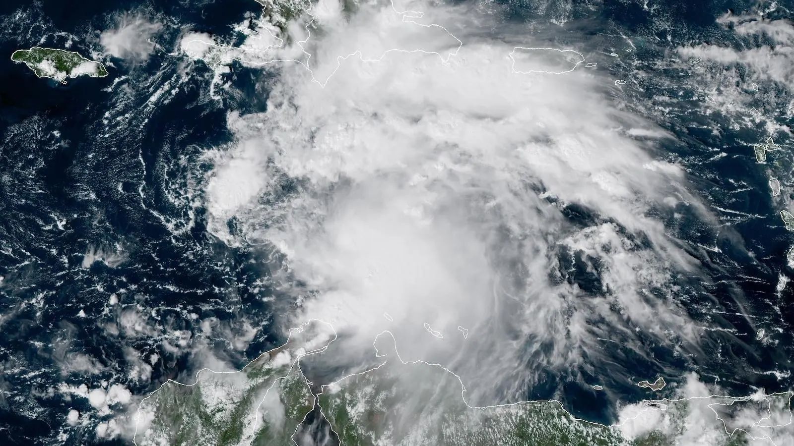
A Hurricane Watch is up for the south coast of Haiti and a Tropical Storm Watch for Jamaica as newly-formed Tropical Storm Melissa chugs west across the central Caribbean. Melissa is gathering strength over near-record-warm Caribbean waters untouched by any hurricane or tropical storm so far this year, and as of 2 p.m. EDT Tuesday, was located in the central Caribbean about 305 miles (490 kilometers) south of Port-au-Prince, Haiti. Melissa’s top sustained winds were already 50 mph (85 km/hr), and the storm was predicted by the National Hurricane Center to reach hurricane strength by Saturday. Melissa was moving just north of due west at around 14 mph (22 km/hr).
The many possibilities for Melissa’s future over the next few days include multiple days of torrential rain over some of the Caribbean’s most flood-vulnerable places. Disastrous flooding and mudslides are an increasing threat for Haiti, as well as across the southern Dominican Republic. Because of high wind shear from the placement of the subtropical jet stream from Florida eastward through the Bahamas, Melissa is not expected to pose any threat to the continental United States for at least the next week, and ensemble models indicate only a remote chance that the storm could end up far enough northwest to affect Florida.
Melissa is the 13th named storm of the 2025 Atlantic season, forming just four days before the average arrival of the season’s 13th named storm — October 25 (across the period 1991-2020).
You may like
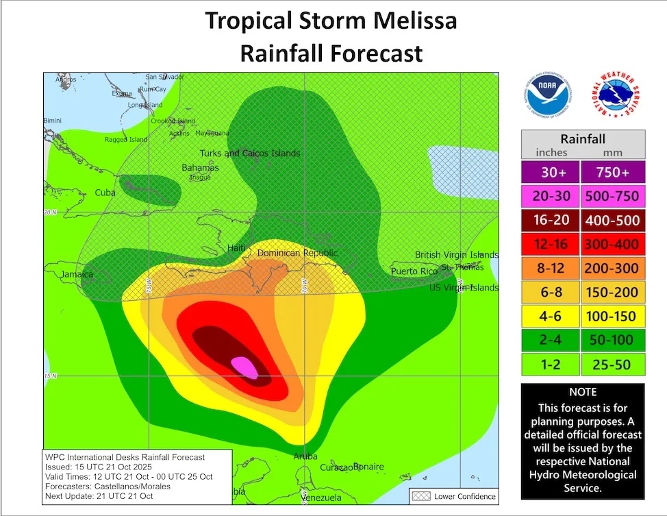
Based on the projected track of Hurricane Melissa as of 11 am. EDT Tuesday, October 21, rainfall totals through Friday could reach 8 to 12 inches (200-300 millimeters) along parts of the south coast of Hispaniola, with more widespread amounts of 4-6 in (100-150 mm). These amounts and locations could change dramatically depending on how the storm evolves, and torrential rains will likely extend well beyond Friday in some areas. (Image credit: NOAA/NWS/WPC via NHC)Near-record-warm Caribbean waters will fuel Melissa’s growth
Although we’re near the tail end of the Atlantic hurricane season, the Caribbean is where you’d most expect to see a named storm develop in mid-to-late October, since wind shear farther to the north has typically become too strong for tropical cyclones. At this point in the year, the Caribbean’s waters haven’t usually cooled too much from their seasonal peak, while the wind shear that so often makes the Caribbean a “graveyard” for incipient tropical systems has typically lessened.
This week, Melissa will traverse some of the warmest waters ever recorded this late in the season anywhere in the Atlantic basin. Averaged across the Caribbean, sea surface temperature was at least 0.5 degree Celsius (0.9°F) warmer as of Sunday, October 19, than in any year on that date except 2023 and 2024, as analyzed by the University of Arizona’s Kim Wood.
Human-caused climate change has made the current warmth in the central Caribbean an incredible 500 to 800 times more likely to occur, according to Climate Central’s Climate Shift Index (see Fig. 2).
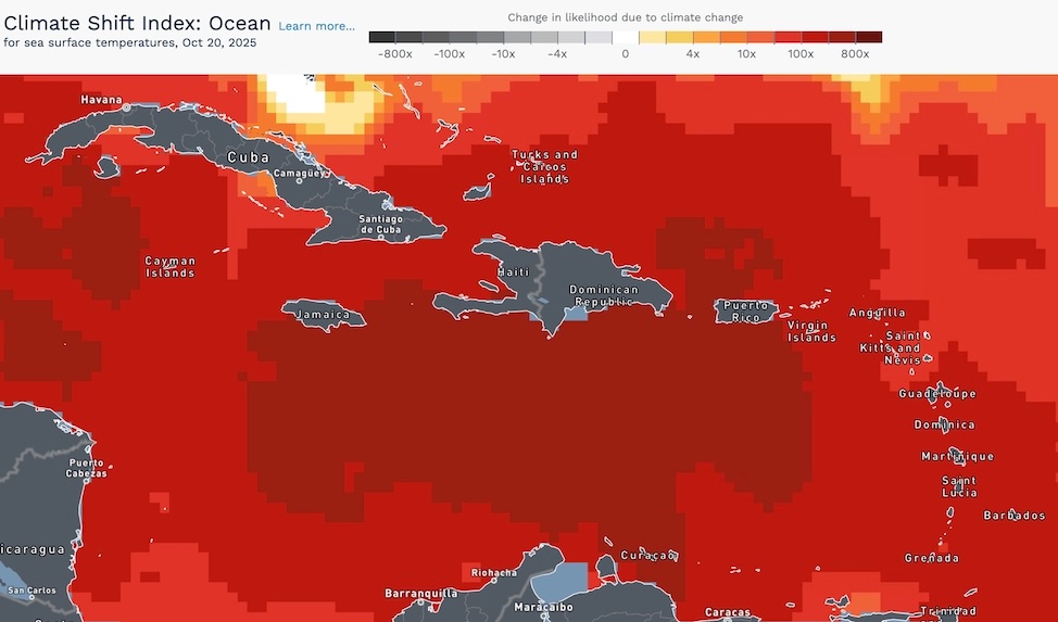
The oceanic version of the Climate Shift Index, depicted here for Monday, October 20, 2025, shows the amount by which human-caused climate change has raised the odds of unusual warmth in sea surface temperatures. (Image credit: Climate Central)Where will Melissa head?
If Melissa were to follow the initial forecast from the National Hurricane Center issued at 11 a.m. EDT Tuesday, it would slow to a crawl just south of Haiti into the weekend (and perhaps beyond) while still gathering strength — a recipe for potentially devastating floods and mudslides over southern Hispaniola. Poverty, governmental instability, and deforestation have left Haiti extremely vulnerable to the kind of disaster Melissa could inflict.
That said, forecast models have been far from unanimous on Melissa’s future (see Fig. 3 below). Part of the problem is that the storm lacked a well-defined center until Tuesday. Now that Melissa is a bona fide tropical storm, we may well see an increasing amount of model agreement. However, it appears steering currents will be weak, and slow-moving storms can be problematic for even the best forecast models.
Through early Tuesday, the European model continued to favor a slow westward track, with most of the European model ensemble members keeping the system in the Caribbean through at least next Monday, October 27 (left side of Fig. 3), though a substantial minority bring Melissa toward western Haiti. The GFS (American) model (right side of Fig. 3) has been just as insistent that Melissa will make a northward turn and leave the Caribbean, but its ensemble members differ starkly on the timing and location of that turn. The Google DeepMind AI-based model, which has been a top performer on track this year, also leans toward an eventual northward turn but again with sharp variations among ensemble members on its timing and location.
Intensity forecast for Melissa
Steady strengthening appears to be a safe bet for Melissa over the next several days. The storm is embedded in an uncommonly moist atmosphere: mid-level relative humidity will be climbing from 70-75 percent on Tuesday to as high as 80 percent by Wednesday. Wind shear was a moderate 10-20 knots on Tuesday afternoon, and is expected to remain moderate to high for a couple of days. High pressure at upper levels is predicted to build over the Caribbean toward this weekend, which would favor strengthening.
You may like
As well as unusually warm surface waters, the Caribbean has ample oceanic heat extending to a substantial depth right now, so even a slow-moving Melissa is unlikely to be greatly hindered by churning up cooler subsurface water. NHC was not predicting Melissa would rapidly intensify over the next five days, but the 18Z Tuesday SHIPS model forecast called for a 12% chance of rapid intensification of 35 mph in 24 hours, and a 25% for rapid intensification by 75 mph in 72 hours. That would put Melissa at category 3 strength on Friday afternoon, with 125 mph winds.
If the forecast scenario of an “M” storm in October cruising into the Caribbean, stalling, and turning north as a major hurricane seems familiar to you, it should: this outcome would be remarkably similar to what we saw with Matthew in 2016.
bmcnoldy.blogspot.com/2025/10/meli…
#Melissa
— @bmcnoldy.bsky.social (@bmcnoldy.bsky.social.bsky.social) 2025-10-23T12:03:13.447ZThe dangers of late-season hurricanes in the Caribbean
Slow-moving, late-season systems that gain strength in the Caribbean can cause immense trouble. In early October 2016, Hurricane Matthew moved north over far western Haiti as a Category 4 hurricane, dumping more than 20 inches (500 mm) of rain over much of far eastern Cuba and southwestern Haiti and pummeling the Bahamas and several other islands. Matthew took 731 lives and caused more than $16 billion in damage (2016 USD).
Just over 20 years ago, Hurricane Wilma strengthened with astonishing speed into a Category 5 monster in the northwest Caribbean. On October 18-19, 2005, Wilma set two all-time records for the Atlantic basin for rapid intensification, as the storm deepened from 975 to 892 millibars (hPa) in 12 hours and from 979 to 882 mb in 24 hours — the latter making Wilma the strongest hurricane by central pressure in Atlantic history. Wilma also set a record for the largest 24-hour increase in top sustained winds, going from 75 to 175 mph. Wilma struck Mexico’s Yucatan Peninsula as a strong Cat 4 storm and raced northeast to strike southwest Florida on October 24 at Cat 3 strength. Wilma led to 52 deaths and caused $26.5 billion in damage (2005 USD).
Near the end of October 1998, former Category 5 Hurricane Mitch dumped mammoth amounts of rain over Guatemala, Nicaragua, and Honduras (30 to 40 inches, or 750-1000 millimeters, in many areas) even as it decelerated and weakened, coming onshore at Cat 1 strength. Flooding and landslides caused some $6 billion in damage (1998 USD) and caused more than 11,000 confirmed fatalities, with another 11,000 missing people unaccounted for. Mitch was the deadliest Atlantic hurricane of the satellite-monitoring era (i.e., since the 1960s), and perhaps since the Great Hurricane of 1780.
This article was originally published by Yale Climate Connections.