
Don’t miss out on our latest stories. Add PCMag as a preferred source on Google.
As SpaceX’s Starlink constellation grows, expect the company’s satellites to occasionally photo bomb astronomy images, including those taken by other satellites.
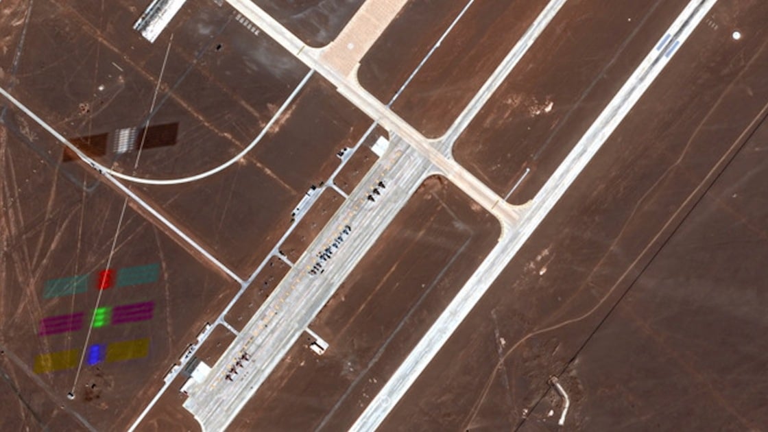
Maxar Intelligence, a provider of satellite imagery for services like Google Maps, recently spotted a Starlink satellite streaking through a photo it took from space last month. “Our satellites were conducting routine Earth observation operations when they captured this shot of a SpaceX Starlink satellite in orbit,” SVP Susanne Hake wrote on LinkedIn.
The company identified it as Starlink satellite 33828, which launched in April. The image was taken from one of Maxar’s WorldView Legion satellites, which are designed to record high-resolution imagery.
In the photo, the Starlink satellite appears to leave a ghostly, rainbow-colored trail because the Legion satellite was “merging high-resolution black-and-white data with color data while the Starlink zipped past at orbital velocity,” Hake said.

(Credit: Maxar Intellgience)
Astronomer Jonathan McDowell, who tracks satellites, also looked at the date and location of the image and told PCMag, “Evidence suggests the image was taken by Maxar’s Legion-6 satellite as it orbited [at] 542km.” The Starlink satellite passed below at about 485 kilometers.
Another suspected Starlink satellite may have popped up in a satellite image discovered on Google Maps back in April.
Maxar’s Hake posted the latest image to highlight the “crowded” space domain, saying it offers both opportunities and complexities for satellite providers. “We’re operating in an interconnected orbital ecosystem where commercial broadband, Earth intelligence, and national security missions share the same highways 340 miles above our heads,” she wrote.
Recommended by Our Editors
It is interesting to think about how the industry will avoid future photo-bombing incidents. But Hake noted that “integrated space domain awareness isn’t just nice-to-have anymore—it’s foundational to mission success.” Meanwhile, SpaceX coordinates with other satellite providers to avoid potential collisions and publishes Starlink satellite position data on space-track.org.
Although the image was taken during routine observations, Maxar snapped it right as the Starlink satellite flew over the Dingxin Airbase in China, where officials have been testing military jets. Researchers in the country have long had concerns about Starlink, with some calling the SpaceX constellation a potential military and spying threat.
Starlink currently spans over 8,000 satellites. Pending regulatory approval, SpaceX plans to expand that to nearly 30,000 satellites to boost coverage and offer gigabit speeds. But some groups are concerned about the potential impact on astronomy and the Earth’s atmosphere.

Get Our Best Stories!
Your Daily Dose of Our Top Tech News

Sign up for our What’s New Now newsletter to receive the latest news, best new products, and expert advice from the editors of PCMag.
Sign up for our What’s New Now newsletter to receive the latest news, best new products, and expert advice from the editors of PCMag.
By clicking Sign Me Up, you confirm you are 16+ and agree to our Terms of Use and Privacy Policy.
Thanks for signing up!
Your subscription has been confirmed. Keep an eye on your inbox!
About Michael Kan
Senior Reporter

I’ve been a journalist for over 15 years. I got my start as a schools and cities reporter in Kansas City and joined PCMag in 2017, where I cover satellite internet services, cybersecurity, PC hardware, and more. I’m currently based in San Francisco, but previously spent over five years in China, covering the country’s technology sector.
Read the latest from Michael Kan