
Following record-breaking floods in March 2025, the usually brown desert surrounding Cooper Creek transformed into a sprawling green corridor, stretching hundreds of miles, an event that locals say they might witness only a few times in their lives.
More than a year’s worth of rain fell in just one week over parts of western Queensland, sending floodwaters racing across the parched landscape. NASA’s Earth-observing satellites monitored the phenomenon from space, documenting how the desert briefly erupted into color and activity before slowly returning to its arid state.
This desert bloom unfolded in the Lake Eyre Basin, one of the world’s few major internally-draining river systems. It offers scientists an opportunity to observe how rare flood pulses can awaken long-dormant ecosystems and how satellite technology is used to track every phase of these extreme environmental shifts.
Record-breaking Rainfall Triggers Massive Transformation
The flood began in late March 2025, when intense rainfall inundated Channel Country, submerging towns and grazing lands. According to satellite data from NASA’s Earth Observatory team at the Goddard Space Flight Center in Maryland, water moved rapidly across the desert terrain, breaking river records and cutting off access to entire regions.
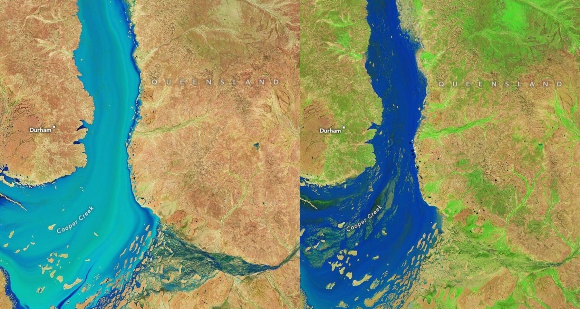
Helicopters were deployed to evacuate residents, and long desert highways remained underwater for weeks. One of the most affected regions was around the town of Windorah, where the Cooper Creek floodwaters later began to shrink. It was here that Landsat satellites recorded the river’s transition—from a flooded ribbon of water to a network of narrow channels surrounded by vibrant green vegetation.
These visual changes were revealed through false-color satellite imagery. NASA applied a band combination that mapped shortwave-infrared, near-infrared, and red light into red, green, and blue, allowing clear differentiation between water, bare soil, and vegetation. In these images, open water appeared electric blue, photosynthesizing plants bright green, and dry land pinkish tan.
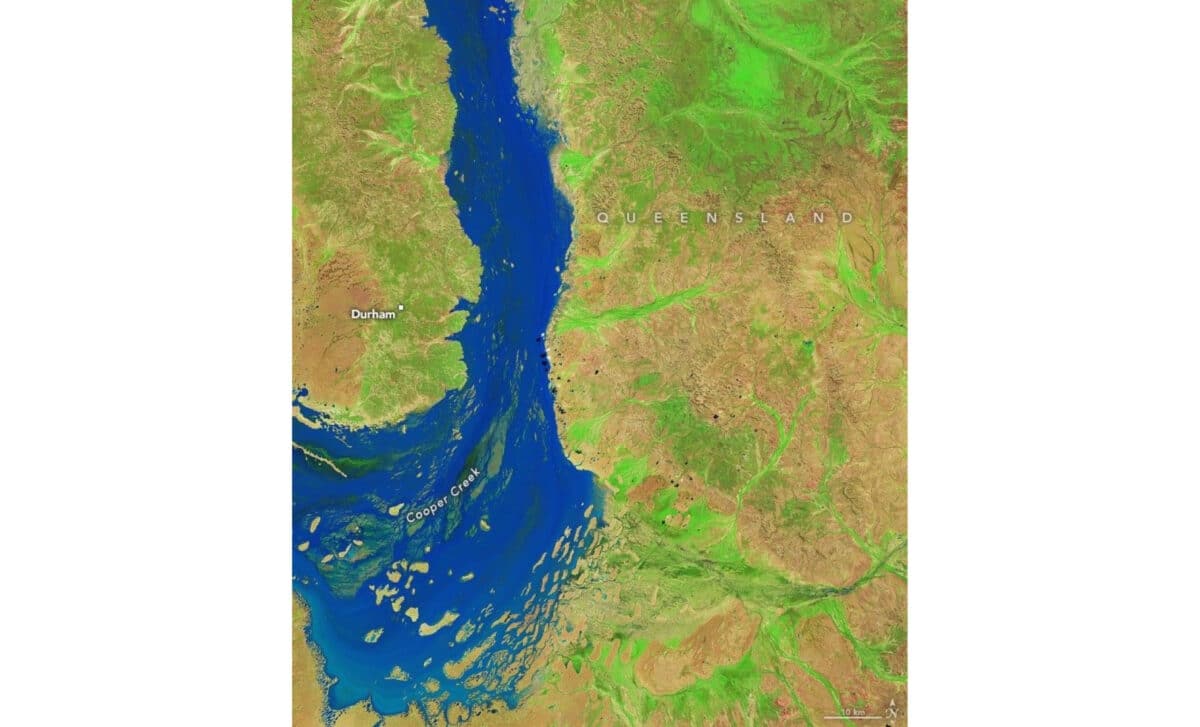 Heavy rain in Queensland sent floodwaters coursing through the Australian Outback. Carpets of green emerged in their wake – © NASA Earth Observatory
Rare Inland Floods Reshape Lake Eyre And Its Tributaries
The 2025 flood event reached far downstream, setting records across the Lake Eyre Basin. Coongie Lakes National Park was forced to close, and the town of Innamincka became completely isolated due to rising waters. A study published in Science Direct, confirms that Lake Blanche, one of the system’s terminal lakes, has filled only six times in the past hundred years, reports Earth.com.
At the height of the flood, an estimated 30 million acres of inland terrain were underwater. This included not only natural floodplains but also vast grazing properties, some of which suffered significant damage. In several areas, floodwaters stripped between 8 and 16 inches of topsoil, a loss that will take years to repair as vegetation slowly returns.
NASA’s MODIS sensor also detected transformation at Lake Eyre itself; also known as Kati Thanda. This vast, normally dry salt pan, which typically receives just 5.5 inches of rain per year, briefly turned into a shallow sea. While nearly one-sixth of Australia drains into this basin, records show that Lake Eyre has filled entirely only three times in the last 160 years. Observers on the ground say the 2025 event may rival the legendary flood of 1974, when the lake reached its deepest recorded level.
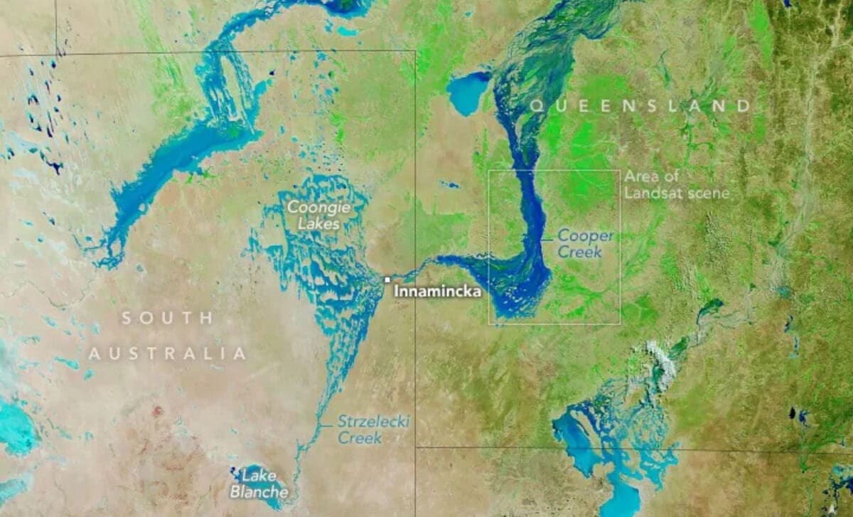 The false-color image above, captured by the MODIS (Moderate Resolution Imaging Spectroradiometer) on NASA’s Terra satellite on April 28, shows a wider view of Channel Country and the ephemeral flooding and greening – © NASA Earth Observatory
Floods Ignite Ancient Life Cycles Across Desert Ecosystems
Beyond its striking visuals, the flood triggered a rapid ecological response. As water spread across dry floodplains, dormant eggs of tiny crustaceans and invertebrates, some buried in the soil for years, hatched almost immediately. These microscopic swarms provided food for fish breeding in the rivers, which then moved toward Lake Eyre and nearby wetlands.
The sudden burst of life follows a short but efficient biological chain. Native plants responded within days, erupting into leaf and transforming the once-barren ground. According to Geoff Penton, operations manager of a regional land group, the flooding is expected to deliver a “massive boost to the longer-term biodiversity,” even though the damage to pastureland will take much longer to heal.
NASA satellites play a critical role in tracking these developments. Repeat imaging of riverbeds, floodplains, and terminal lakes allows scientists to estimate how water pulses are moving and when they are likely to arrive at sensitive ecological zones like Coongie Lakes and Lake Eyre. This supports not only scientific research but also helps remote communities, park managers, and conservationists prepare for nesting events, fish migrations, and tourism planning.
Lessons From A Rare Desert Flood
Arid river systems like Cooper Creek are defined by boom-and-bust cycles, swinging from lifeless dust to biological richness depending on upstream rainfall. These swings are a natural feature of the Lake Eyre Basin, but the 2025 flood stands out as one of the most extreme events on record.
Unlike many large river networks around the world, the Lake Eyre Basin remains largely unmodified. There are no major dams or irrigation schemes interfering with natural flows. An intergovernmental agreement keeps these rivers free-flowing, ensuring that major flood pulses can still travel uninterrupted across vast distances to revive remote ecosystems.