6h agoThu 19 Mar 2026 at 9:07pmStay up to date with the latest emergency warnings

You can head to the ABC Emergency website for all updates, including a map of all warnings.
ABC Emergency will broadcast regular warnings on ABC Radio, which you can stream on the ABC Listen App.
Here are the radio frequencies for local stations:
Cairns and surrounds: 801 AM and 106.7 FMCairns North: 95.5 FMCoen: 105.9 FMCooktown: 105.7 FMLakeland: 106.1 FMLaura: 106.1 FMMossman and surrounds (including Daintree, Port Douglas): 639 AMWeipa: 1044 AM
ABC Far North is also available on Channel 211 through the VAST satellite service.
You can also keep across the latest warnings from the Bureau of Meteorology on its website.
3m agoFri 20 Mar 2026 at 3:09am
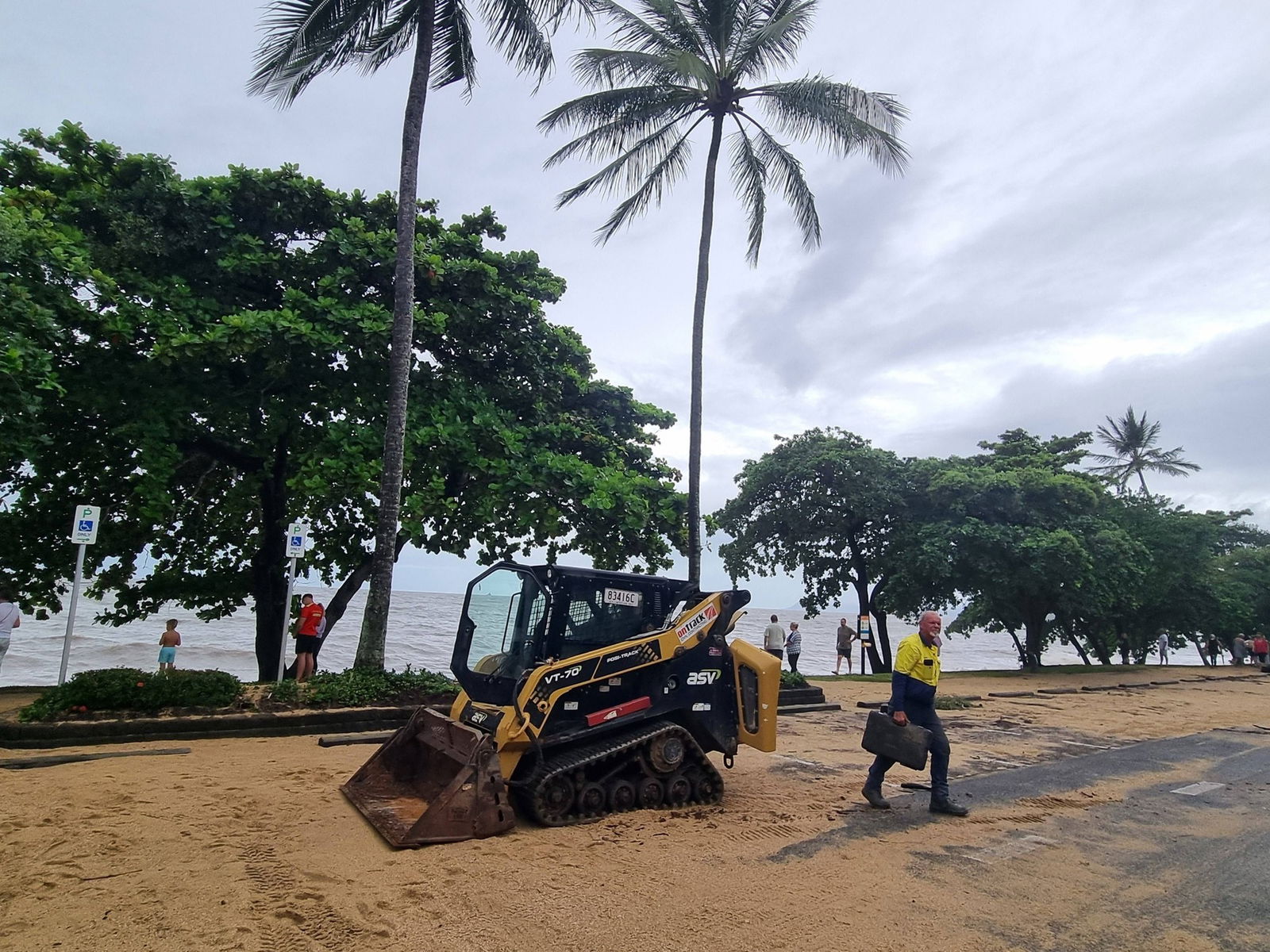
Coastal damage at Palm Cove
Some more photos are coming in from the area around Cairns, which is experiencing a strong storm surge.
The photos are supplied by Cairns councillor Brett Olds and ABC reporter Kristy Sexton.
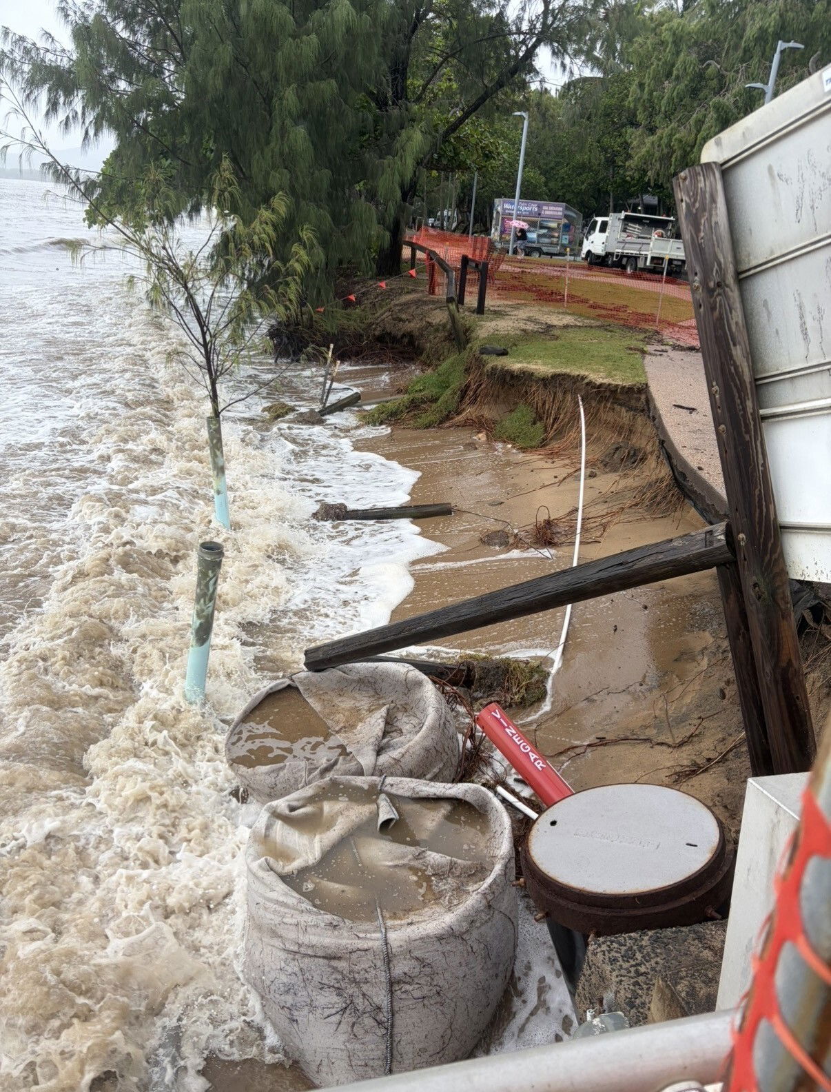
Adjunct professor at the Centre for Disaster Solutions at James Cook University Jonathan Nott has told ABC Far North some of the beaches are also accreting or gaining more sand due to the heavy winds and surf.
“There is some substantial erosion at Clifton Beach, and at Palm Cove too,” Professor Nott says.
“I’ve already seen benches, tables and slabs of concrete falling into the ocean.
“There’s trees looking very precarious at the moment, and other sections where the beach is building up in volume.”
12m agoFri 20 Mar 2026 at 2:59am
NT mine prepares for Cyclone Narelle
A major mining operation on a small island off the NT coast is preparing for Cyclone Narelle.
The GEMCO manganese mine on Groote Eylandt is bracing for impact, which is forecast from late tomorrow and into Sunday.
A spokesperson for South32, which operates the mine, says staff are starting to be moved off site.
“Our teams are progressing cyclone preparedness activities, including moving non-essential personnel off site. We are working with the Local Emergency Controller to monitor the situation.”
21m agoFri 20 Mar 2026 at 2:51amUpdate from Bureau of Meteorology
Weather bureau senior meteorologist Christie Johnson has given an update on ABC Radio Far North with Adam Stephen.
Tropical Cyclone Narelle is continuing west, picking up some speed as a category three system and moving at about 25km/hSustained winds at the centre of the system of 140km/h, with gusts up to 195km/hThe system is weakening a little, with winds dropping slightly in the past hourIt’s forecast to enter the Gulf as a category two, before re-intensifying to a category three over waterAurukun is right in the cyclone’s path, and could see destructive wind gusts of 160km/h or more this afternoon
28m agoFri 20 Mar 2026 at 2:43am
State has the back of local councils for clean-up

The Queensland premier says the state has the back of local councils when it comes to cleaning up.
David Crisafulli says they will work quickly to get houses repaired and schools reopened.
“I can’t stress how important it is that we do that swiftly,” he says.
He says having people on the ground will help bring a sense of calm.
34m agoFri 20 Mar 2026 at 2:38am
Cyclone to intensify as it crosses gulf, premier says
Premier David Crisafulli has just provided another update on ABC News Channel.
He says the cyclone is moving quickly west and is expected to intensify as it crosses the Gulf of Carpentaria.
He praises the people of Far North Queensland for overwhelmingly doing the right thing and sheltering in place when needed.
48m agoFri 20 Mar 2026 at 2:24am
Archer River seeing significant rises
That’s where we’ll leave the Northern Territory authorities’ press conference.
Back in Queensland, taking quick look at a traffic camera over the Archer River shows just how much rivers have swelled since Tropical Cyclone Narelle made landfall this morning.
Pictured here is a before-and-after of Peninsula Development Road, where it crosses the Archer River in Far North Queensland.
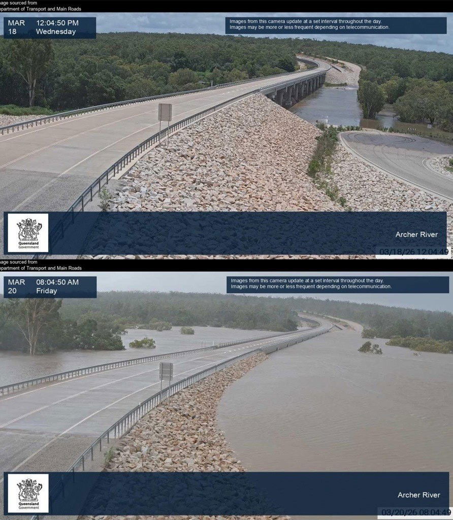 (Dept. of Transport and Main Roads)
57m agoFri 20 Mar 2026 at 2:15am
Evacuees coming to Darwin

NT Police Commissioner Martin Dole says authorities are managing many evacuees from across the Northern Territory, but they are confident they have enough accommodation.
He says Nightcliff High School is only being used as a staging area for evacuees from Numbulwar, who will later move to Foskey Pavilion at the Darwin Showgrounds.
Evacuees from Daly River and Palumpa, who have been in Darwin for a number of days, are being moved to accommodation in Batchelor.
Commissioner Dole says the Centre for National Resilience at Howard Springs is not being considered for housing evacuees.
1h agoFri 20 Mar 2026 at 2:10am
Nhulunbuy on watch but impact expected to be less
Nhulunbuy, another major population centre in the NT, is now included in the cyclone watch area.
Shenagh Gamble from the BOM says TC Narelle is expected to hit Nhulunbuy as a category two storm.
She says residents can expect strong winds of up to 160km/h and heavy rainfall.
Flash flooding is also possible.
1h agoFri 20 Mar 2026 at 2:07am
Preparedness a ‘shared community responsibility’
NT Fire and Emergency Services Commissioner Andrew Warton said:
“While we do everything we can to serve and protect the public, emergency services can’t be everywhere – emergency preparedness is a shared community responsibility.
He acknowledged many have been affected by the recent weather events.
“But I urge you not to be complacent, we’re not through this yet – prepare now,” he said.
“Stay informed by listening to ABC, the emergency broadcaster, follow SecureNT, please be prepared, be informed and stay safe.”
1h agoFri 20 Mar 2026 at 2:03am
How you can prepare for the cyclone in the NT
NT Fire and Emergency Services Commissioner Andrew Warton says people should be preparing for what is to come, explaining the warnings we can expect.
A watch and act alert will come with an orange symbol, which indicates people should take action preparing their property.
“If you plan to shelter elsewhere, you should leave at this stage,” Mr Warton says.
When TC Narelle is imminent, a warning alert, with a red symbol, will be issued. This means sheltering indoors as your life could be at risk.
1h agoFri 20 Mar 2026 at 2:01amSeventh high-risk weather event for the NT this season
Andrew Warton, Commissioner of NT Fire and Emergency Services, has thanked emergency services for their endurance through the season.
“This is the seventh high-risk weather event the Northern Territory has endured over the past five months,” he said.
“What that means is that our river systems across the Top End are at a state of responsiveness.”
He urged people to check their cyclone kits and have their cyclone plans in place.
What you need in your emergency kit for cyclones and severe weather.
1h agoFri 20 Mar 2026 at 1:58am
Darwin not directly impacted but should expect heavy rain
Shenagh Gamble from the BOM says TC Narelle is not expected to directly impact Darwin and surrounds, however as the system passes to the south, residents should expect heavy rain.
Nhulunbuy, Borroloola, Groote Eylandt, Numbulwar, Ngkurr and Bulman are currently under cyclone watch, with the BOM expecting to upgrade the alert to a warning for some communities this afternoon.
A flood watch is current for all of the Top End, and major flood warnings are in place for Katherine, Beswick and the Daly River region.
1h agoFri 20 Mar 2026 at 1:53amKatherine warned to expect major flooding
The BOM’s Shenagh Gamble says the Katherine river responds very quickly to rain and the catchment is already saturated, so rain in or around the town will likely cause flooding.
The area is expected to receive between 150mm and 200mm of rain in the coming days.
Ms Gamble says residents should prepare for a potential flooding event on Monday morning.
1h agoFri 20 Mar 2026 at 1:51am
TC Narelle expected to impact the NT from tomorrow afternoon
BOM spokesperson Shenagh Gamble says the central core of the cyclone will pass over Groote Eylandt overnight tomorrow as a category three system, with peak wind gusts of up to 200km/h.
This expected to cause power outages and structural damage.
She says further out from the central core there is still a risk of damaging winds.
Tides will also be higher than usual and around 200mm of rain is expected, which may lead to flash flooding.
1h agoFri 20 Mar 2026 at 1:44am
Field hospital being set up in Katherine
Len Notaras from the Australian National Critical Care and Trauma Response Centre is speaking now.
He says the field hospital in Katherine will have senior staff deployed to the area to assist the work already going on across the region.
“Folk have been through a lot already and they will be going through a lot more,” he says.
Mr Notaras says his team will be able to take the burden off the Katherine hospital that could occur during the forecast flooding.
1h agoFri 20 Mar 2026 at 1:39am
NT authorities are giving an update on preparations for TC Narelle
Northern Territory Deputy Chief Minister Gerard Maley says Tropical Cyclone Narelle is expected to hit the NT coast as a category three or four storm.
He says it is expected to cause significant flooding events right across the territory.
A major flood alert has been issued for Katherine, with major to moderate flooding over the weekend and a field hospital is also being set up in the town.
1h agoFri 20 Mar 2026 at 1:25am
Cooktown bracing for rain as cyclone crosses to the north Cooktown local Steve Hodkinson (ABC NewsL Christopher Testa)
Cooktown is not in the direct path of Tropical Cyclone Narelle. It was initially in the warning zone but that alert was cancelled in the early hours of this morning.
Local Steve Hodkinson says he is expecting rain from the system will cause roads to be cut.
“We will be short of food and that sort of thing but we will survive,” he says.
“The people who live here, we are used to a cyclone season.”
Steve says his thoughts are with those who are in the cyclone’s path.
“It’s a dangerous time and we hope everyone is safe and well prepared,” he says.
It is the first time Kim Sadleir has been near a cyclone and says it has been “a little bit nerve-racking”.
She says the focus now is on keeping the kids occupied and trying to stay out of the weather.
1h agoFri 20 Mar 2026 at 1:18am
Latest tracking map shows TC Narelle as category three system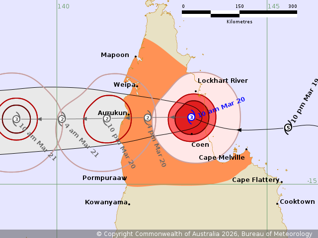 Tropical Cyclone Narelle is now a category three system. (Supplied: Bureau of Meteorology)
Tropical Cyclone Narelle started crossing the coast at about 7am as a category four system.
As we reported earlier, it has now been downgraded to a category three system.
It’s now moving westwards, currently passing about 45 kilometres north of Coen.
The warning zone is from Cape York Peninsula between Lockhart River and Cape Melville, and between Mapoon and Pormpuraaw, including Coen, Weipa, and Aurukun.
There are sustained winds near the centre of 155km/h with wind gusts up to 220km/h.
2h agoFri 20 Mar 2026 at 1:02am
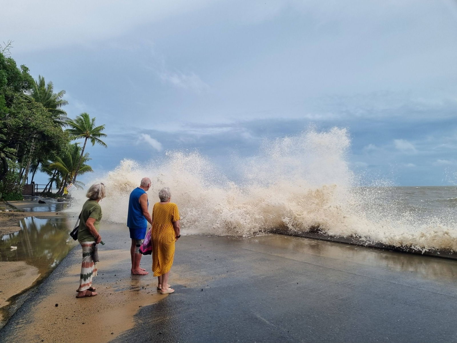
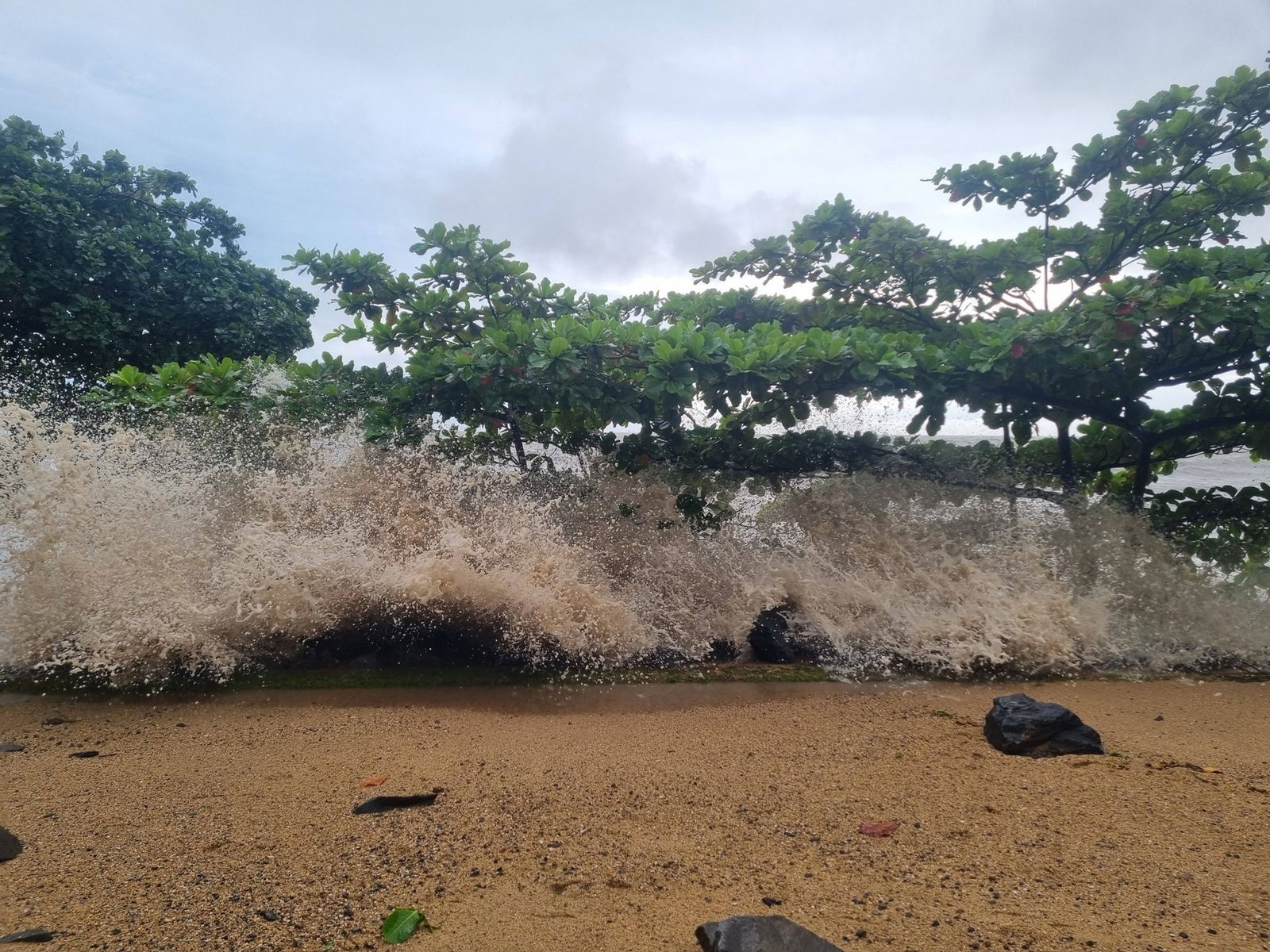
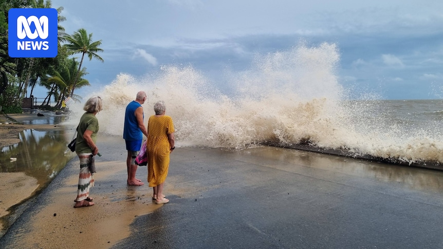
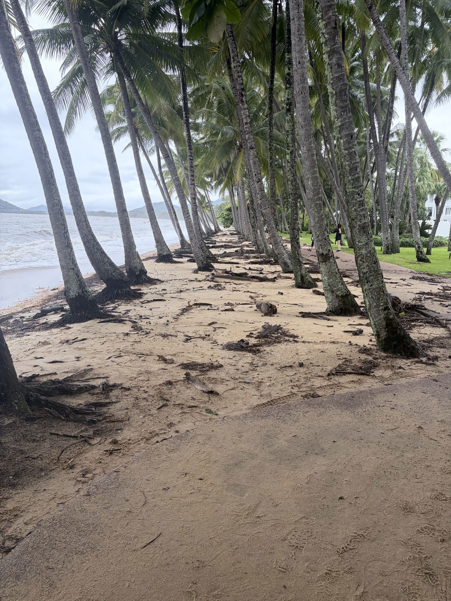
Cairns impacts in photos
Despite being about 600km away from the eye of the storm, Cairns is copping some heavy seas.
These photos, captured by Shelley Sparrow at Trinity Beach, show the shore being pummelled by a large storm surge.