
The last week has seen not one but two important additions to Auckland’s cycling network, a positive sign of what’s possible in otherwise stressful times.
On Tuesday, a dawn karakia marked the official completion of the Great North Rd improvements.
Some of the many people who contributed to getting Great North Road’s glow-up over the line – a task that for a while there, felt impossible. Image: Tammy Flavell for Auckland Transport.
The bike lanes along the ridge have already been open for some time, and they have made a huge improvement to both the corridor itself, and all ages access to and around adjacent neighbourhoods.
December 2025: Just after the tim-tams went in on Great North Rd, early riders trying out the lanes. Image: Jolisa Gracewood
January 2026: parent and child using the bike lanes on Great North Road. Image: Jolisa Gracewood
March 2026: cargo bike family using the bike lanes on Great North Road. Image: Jolisa Gracewood
Meanwhile, last Friday the long-awaited first boardwalk section of the Te Whau Pathway was officially opened to the public.
People enjoying the new boardwalk section of Te Whau Pathway. Image: Auckland Council
The event was covered by Our Auckland:
How would you like to walk or cycle alongside the Whau awa? A key section of Te Whau Pathway is complete and open for Aucklanders and visitors to use and enjoy.
The Northwestern Cycleway to Horowai Reserve section in Te Atatū was completed earlier this year.
More than a hundred people attended the opening ceremony on 20 March, mostly from the local community.
Councillor Shane Henderson has been involved in this partnership project with Te Whau Pathway Environment Trust since it began in 2014. He says this major milestone is an asset for Tāmaki Makaurau, especially those in the west.
“The new boardwalk stage of the Te Whau Pathway is a major piece of infrastructure ready for Aucklanders to walk or cycle on, doubling as a new sustainable transport route or place to exercise.
“The pathway will particularly benefit the West Auckland community, and is a vital connection between the northwestern cycleway and Horowai Reserve.
This project has been such a long time in the dreaming, planning, and arriving – kudos to all those who have clung fast to the vision! – with a vital boost arriving via Crown funding from the last government for this critical section.
While the completion of the full project (which will run from Te Atatū to New Lynn, linking the Waitematā and Manukau harbours) is still some way off, this new section of pathway is a really useful addition.
Bike Te Atatū organised a group ride along the new path, which features pop-out observation decks for pausing to enjoy the views. Image: Jane Clark, via Bike Te Atatu
As well as giving people access to – and a fresh perspective on – the Whau River and its environment, the path also gives many people in Te Atatū South a great, safe, scenic new way to connect to the NW cycleway. Very welcome in the current context, especially as the other main link from south of the motorway, Te Atatū Road, remains pretty hostile for cycling.
Not a render: an aerial shot of the new path in action. Image: Auckland Council
It’s also not often you hear of a project – especially with design and engineering like this – coming in under budget. In fact, it came in far enough under budget for an extra 400m to be built:
The shared path is 1.3km of 4m wide boardwalk sections and 3m wide concrete paths connecting the Northwestern cycleway and Horowai / Roberts Field in Te Atatū South. The build went well, delivering ahead of original planned time and under budget.
…..
In September 2025 the government confirmed funding for the next stage of the pathway – a 400m stretch linking Ken Maunder Park and Rizal Reserve via a new bridge. The funding was prioritised from savings on the original planned section of the pathway that opened on 20 March. Construction on this additional section is due to start in April and be completed before November this year.
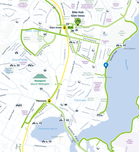
The section just completed is the green section at the northern end of the project on the map below, while the freshly funded section is in blue. (The orange sections are currently unfunded, and the other green sections have been completed.)
Map from Te Whau Pathway project, showing the completed sections in green, and unbuilt sections in orange. The latest section to be funded is in blue.
This does raise the question of what next…
Of course it will be great to see Te Whau pathway continue to develop towards completion. It already has resource consent, and much of the design work is now done. Plus there’s bound to have been a lot of knowledge gained in building the boardwalk that would enable other sections to be built easier.
That got me thinking: what if we could take what’s been learned about construction and design from Te Whau, and replicate it along the nearby Henderson Creek – linking up Massey, Royal Heights, West Harbour and Hobsonville.
This would open up more options for people in how they travel for work, education and recreation. For example, it would make it much easier – and shorter, and safer – for people living near the path to get to the NW cycleway, or the future busway station at Lincoln Rd.
Or imagine someone living in Te Atatū Peninsula being able to cruise up to the Hobsonville Markets, or many other types of trips.
I’ve also previously suggested a path from Triangle Rd south along the water to expand the catchment of the Lincoln Rd station.
Map by Matt Lowrie, showing the potential for additional waterside paths along Henderson Creek, Te Wai-o-Pareira, in the neighbourhood around Te Atatū and westward.
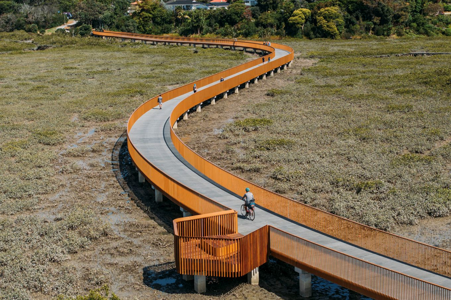
We’ve seen – and will continue to see – some other similarly impressive off-road paths around Auckland. The Eastern Path from Glen Innes to Tamaki Drive, Te Ara ki Uta ki Tai is one prime example, with the boardwalk currently under construction to complete the full pathway.
I’m sure there are other locations where this kind of design could result in some more iconic and useful paths for Auckland, maximising access to and enjoyment of the natural beauty of our location, while also expanding travel options.
Where else should be considered?
December 2025: final section under way of Te Ara ki Uta ki Tai/ Glen Innes to Tāmaki Drive pathway. Image: Patrick Reynolds
And, while these spectacular and well-engineered off-road paths are great, let’s not also forget all of the humble, straightforward on-road connections we need to be adding.
For example, with Great North Rd now completed through to Crummer Road, it really highlights the gap though the Grey Lynn shops to Surrey Cres – and then along Old Mill and Garnet Road.
The inner west network taking shape, linking neighbourhoods to shops, schools, work, each other – and the wider cycle network. As yet incomplete sections are in orange. Image: Auckland Transport
To their credit, Auckland Transport has also recently created short stretches of protected cycleway on both sides of Surrey Crescent around Grey Lynn School. This was done as part of a road renewal project, always a smart and budget-friendly way to expand the network.
(It ties in with a stretch of off-road path towards the Bullock Track, which then connects to the existing but somewhat neglected off-road path along the south side of Old Mill Road, where a repaving is somewhere on the near horizon, and will logically include a safety upgrade for all modes.)
A snippet of safety: looking east along a brand new protected bike lane on Surrey Crescent, built to tie in with road repaving and the installation of raised crossing outside Grey Lynn School. February 2026. Image: Jolisa Gracewood
Looking west along the new protected bike lane on Surrey Crescent, built to tie in with a road renewal and raised crossing outside Grey Lynn School. March 2026. Image: Jolisa Gracewood
There’s also of course Green Lane West, where we are awaiting Auckland Transport’s updated design for safe cycling and walking along this critical connection in the heart of the isthmus.
And AT and Waka Kotahi/ NZTA have long had plans in hand for the city centre – including a safer design for Cook Street, and designs for Wellesley Street East that will give people a direct link to walk, bike and scoot from Queen St to the Domain.
And whatever happened to the plan to fill in the gap to link up the Glen Innes end of the Eastern Path to Panmure and the long-distance and local cycleways being built as part of the Eastern Busway project?
This was to have been funded from the cancelled Northern Pathway and proposed bridge but the project and the funding seems to have disappeared into the mists of time. Despite this promise in 2021:
“Another project we want to bring forward to give East Aucklanders more choices is a 1.9km link between Glen Innes and Panmure to connect the new Eastern Busway cycleway with the Glen Innes to Tamaki cycleway.
In short, there’s plenty of opportunities out there to fill in and expand the network. Especially with fuel prices soaring and people searching for easy, immediate alternatives, now is surely a great time to trial some quick, affordable, pop-up installations to give people options to avoid driving for every trip.
What’s top of your list?
No need to fret about the political popularity of such a proactive response. As well as the growing local ridership and demonstrable uptake whenever the network is added to, you only have to look at Paris, where Anne Hidalgo’s successor Emmanuel Grégoire has just been enthusiastically elected on a platform of doing even more street transformations and continuing to expand the city’s cycle network.
Plus it’s always nice to see local leaders on their bikes, rightly enjoying kudos for their productive investment in freeing up choices about how we get around.
Simon Bridges, John Key and Len Brown opening the Quay St interim cycleway in July 2016 (Image: Auckland Council)
Greater Auckland’s work is made possible by generous donations from our readers and fans. We’re now a registered charity, so your donations are tax-deductible. If you’d like to support our work, you can join our circle of supporters here.
Share this