
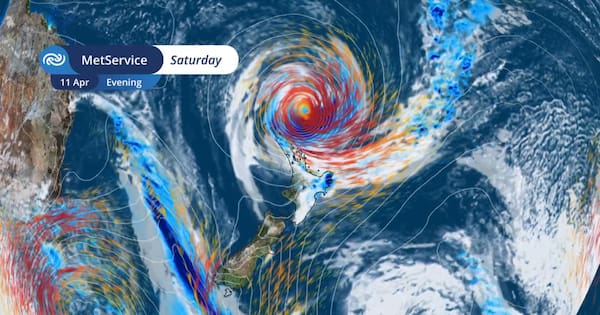
MetService has outlined the potential path of Cyclone Vaianu in greater detail this afternoon, as the category 2 cyclone is expected to be a “very large, damaging system”.
“It will be the Far North that first experiences the strong winds, heavy rain, and rough seas brought by Cyclone Vaianu from late Saturday,” MetService said.
The forecaster said overnight Saturday and into Sunday, Cyclone Vaianu would move south-eastwards across the North Island.
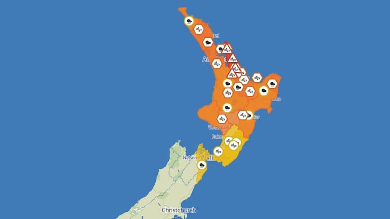
Severe weather warnings and watches cover the North Island and the top of the South Island.
Coromandel Peninsula on North Island’s east coast has been given the most severe warnings ahead of the storm. (Source: 1News)
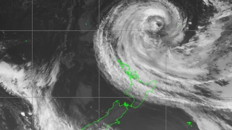
Late last night, Cyclone Vaianu was reclassified as a sub-tropical system which reflects the “changing characteristics of the cyclone”.
“The combination of damaging winds, heavy rain, and coastal inundation makes this a multi-hazard, potentially life-threatening event,” it said
“The locations of the most severe impacts associated with Cyclone Vaianu, such as power outages, falling trees, flooding, slips, road closures, and isolated communities are highly dependent on the cyclone’s track.”
Earlier this morning, MetService meteorologist Heather Keats told Breakfast that the downgrade to a category 2 cyclone “doesn’t change anything for us”.
“It doesn’t change the threat, it doesn’t change the intensity, it simply changes the structure of it. It means it’s not recieving that same tropical fuel that it was getting, so the characteristics change.
Yellow heavy rain watches and warnings issued previously for the entire North Island have now been upgraded to orange for many regions, with a red-level wind warning issued for Coromandel Peninsula and Great Barrier Island on Sunday morning.
She warned of road closures, communities cut off and power outages for regions which had already been hit hard by severe weather over the last few years.
Keats said people often get fixated on the “eye” of the cyclone, but said this was “not the only problem”.
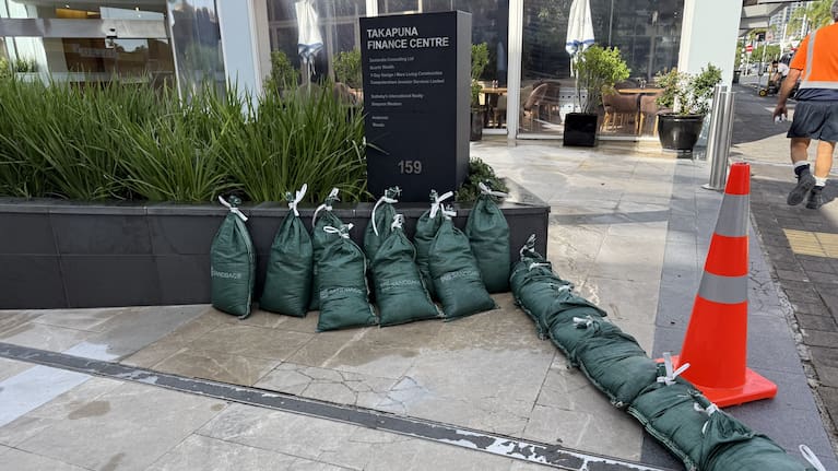
Events cancelled and families pack up ahead of Cyclone Vaianu coming in from the north. (Source: 1News)
“Some of the worst weather we experience with cyclones in New Zealand is actually hours ahead of that front arriving.
“So yes, that ‘eye’ if you like, is expected to hit over the top of the Coromandel, move over the Bay of Plenty and out over Hawke’s Bay to that east over Sunday. But we’re experiencing very, very heavy rain and strong winds hours ahead of that eye arriving.”
NEMA urges people to prepare
NEMA’s Director of Civil Defence Emergency Management John Price outlined some of the ‘critical’ impacts, and urged people not to be complacent. (Source: Breakfast)
NEMA’s Director of Civil Defence Emergency Management John Price outlined some of the “critical” impacts, and urged people not to be complacent.
“There’s going to be a number of components to the cyclone. It will hit hard, with a big impact on NZ. It will be significant, it will be fast, it will leave us in its wake.”
He said there would be strong winds, downed trees and flooding from intense rainfall.
“We also know with a cyclone or ex-tropical cyclone, you’ll get the impact on the likes of the coast. We’re likely to see anywhere between 6m to 8m swells,” he said.
The morning’s headlines in 90 seconds, including fresh warnings about Cyclone Vaianu, and Melania Trump addresses Epstein rumours. (Source: 1News)
Asked to compare the intensity to Cyclone Gabrielle, he said the modelling was looking more similar to Cyclone Cook in 2017.
“It’s got a very similar track where it came through at the top of the North Island, came through the East Coast.
He said it was the “calm before the storm”, and urged people to take the time to prepare now.
‘We are ready to respond’ – FENZ
Fire and Emergency New Zealand said it was pre-positioning specialist resources, including enhanced rescue and water rescue teams, at areas across the North Island.
“This is expected to be a fast moving and high intensity storm with a wide area of impact, including areas still recovering from severe weather in March,” said FENZ Deputy National Commander Megan Stiffler.
“Flooding, landslides and falling trees can be expected, with consequent impacts on power, communications, and travel.
“We are ready to respond where we are needed, and we have extra resourcing ready to be deployed at short notice.”
Stiffler advised those in affected areas not to drive through floodwaters during treacherous conditions.
“In floodwaters, you can’t tell how deep the water is, or how swift. The road may have been washed away and there could be hidden obstacles,” she said.
“At home, tie or take down trampolines and outdoor furniture and prepare for power outages.
“We recommend using torches and battery powered devices wherever possible to reduce the risk of unwanted fire in your home during a power outage.”
Boaties urged to ‘take special care’
The Ports of Auckland is being cleared of shipping vessels while a stern warning has been issued to boaties.
Auckland harbourmaster Andrew Hayton told 1News his team had been working closely with the Ports of Auckland to determine shipping schedules for large commercial vessels.
“Most of them have delayed their entry into Monday, and we’ll be sending some of them to sea on Saturday so they’re not in port during the bad weather.”
He said the main focus was on large commercial ships, as this took a lot more effort to organise.
“So the commercial boats are generally taken care of, but recreational boats we’re trying to get the message out there to be prepared. And to go out today.”
“Don’t wait for the bad weather to strike, and make sure your boat is ready to encounter the bad weather that is expected.”
Hayton said there were 3500 boats on rope moorings in the Auckland region. “Those are probably the ones that are the most at risk of bad weather.
“After every storm we always get some that break off and come ashore. So we’re urging people to take special care of their vessels.
“In this particularly instance we’ve got some time to prepare for it, so go out today, make sure that your mooring is in good condition, that loose sails and tied down and there’s nothing loose on deck.”
Hayton said boaties on moorings in exposed locations could consider moving to a marina or sheltered bay over the weekend.
Current watches and warnings
Strong Wind Warning – Red
Coromandel Peninsula and Great Barrier Island – 13 hours from 5am Sunday to 6pm Sunday.
Heavy Rain Warning – Orange
Northland, about and south of Bay of Islands to Hokianga Harbour – 12 hours from 9pm Saturday to 9am Sunday.
Auckland and Great Barrier Island – 12 hours from 2am Sunday to 2pm Sunday.
Coromandel Peninsula, and Bay of Plenty west of Whakatāne including Rotorua – 14 hours from 2am Sunday to 4pm Sunday.
Gisborne/Tairāwhiti north of Tolaga Bay – 14 hours from 2am Sunday to 4pm Sunday.
Strong Wind Warning – Orange
Northland – 15 hours from 11pm Saturday to 2pm Sunday.
Auckland – 19 hours from 9pm Saturday to 4pm Sunday.
Waikato, Waitomo, Taupō and Taumarunui – 12 hours from 10am Sunday to 10pm Sunday.
Bay of Plenty and Rotorua – 15 hours from 4am Sunday to 7pm Sunday.
Gisborne/Tairāwhiti, Hawke’s Bay and Taihape – 16 hours from 10am Sunday to 2am Monday.
Taranaki and Whanganui – 10 hours from 1pm Sunday to 11pm Sunday.
Heavy Rain Watch
Northland north of Bay of Islands to Hokianga Harbour – 12 hours from 7pm Saturday to 7am Sunday.
Waikato – 15 hours from 3am Sunday to 6pm Sunday.
Bay of Plenty about and east of Whakatāne – 15 hours from 6am Sunday to 9pm Sunday.
Gisborne/Tairāwhiti about and south of Tolaga Bay, Hawke’s Bay ranges, and coastal hills south of Napier – 16 hours from 2am Sunday to 6pm Sunday.
Waitomo, Taumarunui, Taupō and Taranaki – 12 hours from 8am Sunday to 8pm Sunday.
Wairarapa, including the Tararua District, also eastern and southern parts of Wellington – 12 hours from 11am Sunday to 11pm Sunday.
Marlborough Sounds, including northeastern areas north of Kaikōura – 10 hours from 2pm Sunday to midnight Sunday.
Strong Wind Watch
Manawatū, Kapiti Coast and Wellington – 19 hours from 11am Sunday to 6am Monday.
Wairarapa, including the Tararua District – 21 hours from noon Sunday to 9am Monday.