

Parts of the South Island and Wellington are in for severe gales, and some heavy rain, according to MetService.
It was a significant shift from the clear conditions which had caused temperatures to plummet at the start of the week.
The forecaster said a front preceded by strong northerly winds would move across the country, bringing brief heavy rain on Thursday and Friday.
“An associated complex low moves over the southern South Island Friday morning and is followed by a strong and cold southerly change,” it said.
A yellow heavy rain watch was issued for the Tararua Range from midnight until midday tomorrow.
Yellow strong wind watches were also issued for Wellington, Canterbury high country, coastal Otago and coastal Southland and southern Fiordland into Friday.
Meteorologist John Law said there would be some “wetter, windier weather moving back across the country today”.
“Running up that western coast with a risk of some thunderstorms around that western side of the South Island.
“By the end of the day, that wet weather makes its way up toward the North Island, with some stronger winds around the likes of the Canterbury high country,” he said.
Law said it would still be frosty first thing for some places this morning including Hastings, towards Taupō and parts of the Waikato.
NZTA warns motorists of potential snow impacts
New Zealand Transport Agency Waka Kotahi (NZTA) said relatively mild temperatures today could be misleading for South Island road users as potentially heavy snowfalls loom from tomorrow.
“Those driving in gale-force winds are urged to take extra care, especially those operating high-sided vehicles, towing vehicles and motorcycles,” it said.
From tomorrow, the weather was expected to take a colder turn, as cold air from the southerly flow was expected to move up the island.
Forecasting suggests heavy snow could fall on Friday, in places such as Canterbury’s alpine passes, with 10-20cm possible about and west of Arthur’s Pass, affecting State Highway 73, and in the Lewis Pass area, affecting State Highway 7.
“Snowfalls may fall to as low as 200m elevation on Saturday, while the Mackenzie Basin is expected to get lesser amounts,” NZTA said.
“With snow also forecast for State Highway 94 near Milford Sound tonight, the highway is due to close at 5pm from the Lower Hollyford Road turnoff to The Chasm. This section of SH94 is expected to reopen late tomorrow morning, with potential ongoing snow showers causing further disruptions throughout the day.”
Road users were encouraged to plan ahead by checking the weather and roading conditions, as NZTA may close other state highways where the snowfall puts people at risk.
People were encouraged to carry warm clothing, food and water with them in case of travel delays or detours.
Current watches and warnings list
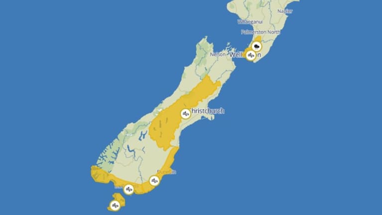
Heavy Rain Watch
Tararua Range – 12 hours from midnight Thursday to midday Friday.
Strong Wind Watch
Wellington – seven hours from 7pm today to 2am Friday.
Canterbury high country – nine hours from 9am to 6pm today.
Coastal Otago – nine hours from noon to 9pm Friday.
Coastal Southland and southern Fiordland – nine hours from 9am to 6pm Friday.