
MetService says temperatures are set to crack the high 20s for some parts of the country, while rain warnings persist for parts of the South Island.
The forecaster said the east coast would record the hottest temperatures, with Napier and Hastings expected to reach 27C and 28C respectively.
Christchurch, Kaikōura and Blenheim were all anticipated to reach 23C to 24C too.
MetService meteorologist Heather Keats told Breakfast that wet and windy weather in the South Island was likely to continue to today as a “moist northwest flow” with a few fronts tracked up the country.
“There are a couple of watches and warnings though that are set to expire by about 10am this morning,” she said.
Yesterday, the forecaster issued some orange heavy rain warnings and strong wind watches expected to hit overnight into today.
In an update at 10am, warnings were lifted across some areas. Watches and warnings remained for Tararua, Wellington, Buller, Tasman, and Canterbury. Several areas were still under heavy rain or strong wind alerts until Saturday or Sunday.
Dan Corbett: Warnings issued with ‘several days of a lot of rain’ to lash country – watch on TVNZ+
Keats said areas including the Tararua Range and Buller District were under rain warnings until 2am Sunday, so they were the areas to “keep an eye on”.
She said despite rain warnings persisting for some areas, there would be “pockets of really nice weather” for others, including Auckland, over the weekend.
Keats even said it would be “hot for some areas”, with places particularly in the east of the country expected to get “windy, but very warm conditions”.
Temperatures soar
She said Hastings would get a high of 28C today, Napier would reach 27C,
“The next couple of days there for the whole Hawke’s Bay, 27C tomorrow, 26C on Sunday and those overnight lows to a really, really mild, well above average.
“Christchurch will be 23C today and 25C tomorrow, so that’s really lovely too.
“Dunedin, 22C today, 24C tomorrow.
“And those places that are seeing really warm daytime temperatures in the east will have those really warm overnight lows.”
The morning’s headlines in 90 seconds, including heavy rain on the way for some, a timeline for the Gaza hostages to be released, and why Princess Catherine says put down your phone. (Source: Breakfast)
She said North Island temperatures had remained “pretty mild too”.
“I mean, Auckland will be 22C today and for the next couple of days as well. And again, some of those overnight temperatures will be quite muggy too, because it’s coming down from the northwest.
“But I think if we’re thinking best places to be this weekend, I think Auckland might take that, well, at least tomorrow, which is, it’s rare for me to say that.
“It’s been a pretty brutal winter and spring for Auckland, but it’s going to be a really lovely weekend, mostly dry, a little bit of cloud, 22C the high.”
However, Kiwis were warned to make the most of the good weather as next week temperatures would return back to “more average” spring temperatures.
Fresh slips, road closures – NZTA
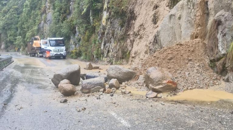
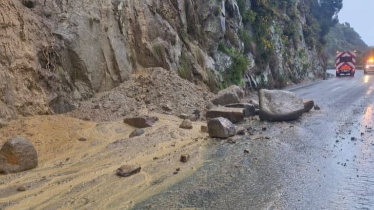
New Zealand Transport Agency Waka Kotahi (NZTA) said heavy rain had caused slips and flooding on parts of State Highway 7, State Highway 73 and State Highway 6 on the West Coast this morning.
On State Highway 7, road users were warned to take extra care when travelling between Lewis Pass and Springs Junction, and between Reefton and Ikamatua.
On State Highway 73 between Arthur’s Pass Village and Kumara Junction, extra care was urged because of flooding and slips.
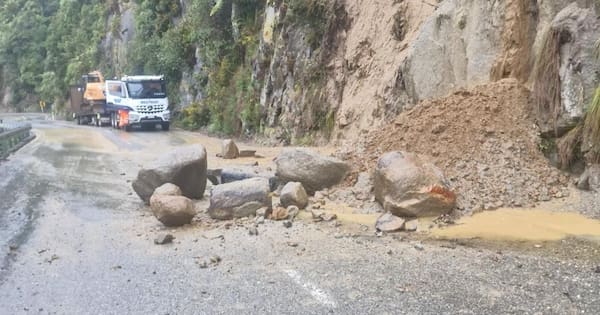
“There have also been rockfalls on State Highway 6 near Meybile Bay, north of Punakaiki,” an NZTA spokesperson said.
Full list of watches and warnings
Heavy Rain Warning – Orange
Tararua Range – 52 hours from 2pm today until 6pm Sunday.
Buller District – 29 hours from 9am today until 2pm Saturday.
Grey District – five hours from 9am until 2pm today.
Headwaters of the Canterbury lakes and rivers north of about the Hurunui River – five hours from 9am until 2pm today.
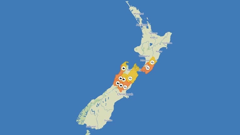
Strong Wind Warning – Orange
Wellington and Wairarapa, excluding the Tararua District – 17 hours from 9am today until 2am Saturday.
Canterbury High Country north of the Waimakariri River – four hours from 9am until 1pm today.
Heavy Rain Watch
Tasman District west of Takaka – 37 hours from 9pm today until 10am Sunday.
Nelson Lakes – 30 hours from 9am today until 3pm Saturday.
Strong Wind Watch
Tararua District – 37 hours from 9am today until 10pm Saturday.
Marlborough – five hours from 9am until 2pm today.