
Snow looks set to fall across a massive chunk of the UK in the days before Christmas as advanced weather maps suggest some regions could see several inches
15:19, 06 Dec 2025Updated 15:29, 06 Dec 2025
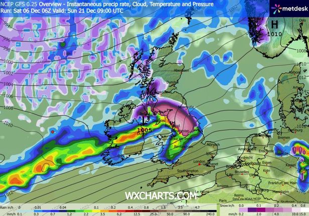
 Snow falling (in purple) at 6pm on December 20(Image: WX Charts)
Advanced weather modelling maps show as many as three snowstorms could sweep across the UK in the days before Christmas, meaning the white stuff might still be on the ground by December 25.
Roughly half the country could be impacted by the Arctic blast, the GFS weather model suggests, with several inches of snow expected in some regions.
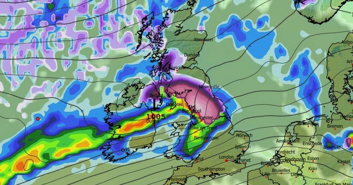
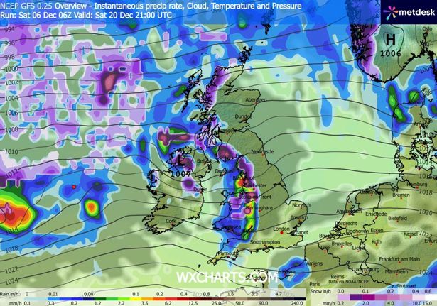
The wintry chaos looks set to get underway on December 20, with snow and rain falling as an Atlantic weather front sweep across the UK. Northern Ireland looks set to face the most intense flurries initially, before Wales, the Midlands, the north of England and Scotland also see some flakes.
 Snow falling (in purple) at 9pm on December 20(Image: WX Charts)READ MORE: Met Office urges Brits to prepare ’emergency’ kit and three items for next weekREAD MORE: UK snow: Exactly where freeze to hit by tonight – see if you’re affected
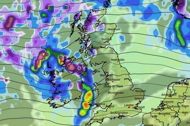
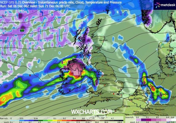
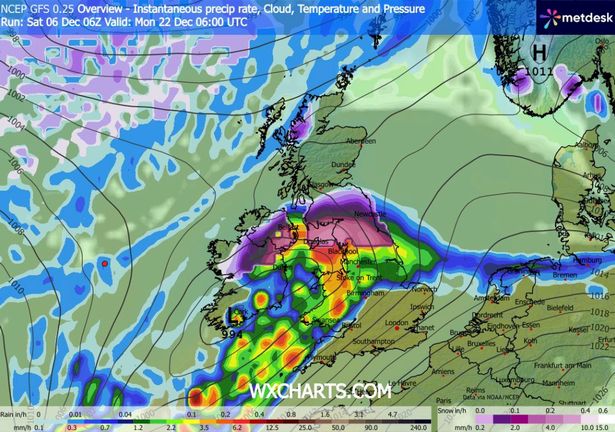
The second snowstorm is tracked to hit Northern Ireland at 6am on December 21, possibly bringing 1cm per hour. Again this snow will then drift over the rest of the UK, the maps suggest, with the north-west of England where the most intense flurries are expected.
Shockingly, weather maps for December 22 show a third snowy front dumping several centimetres in Northern Ireland, the north of England and Scotland. It awaits to be seen whether temperatures will remain low enough for snow to remain on the ground into Christmas Day.
 A second snowstorm is expected at 6am on December 21(Image: WX Charts)
Snow coverage maps for December 22 show some of the white stuff settled on the ground across roughly half the UK, covering almost every region above Manchester. The data suggests 12cm (roughly five inches) could settle in the north of Scotland, with 6cm possible in some places in northern England and Northern Ireland.
Met Office Christmas weather forecast
The Met Office forecast suggests snow could come late on in December. Its forecast for December 20 to January 3 states: “Changeable conditions are expected across the UK during this period.
 Snow falling (in purple) at 9am on December 21(Image: WX Charts)
“Low pressure systems will probably dominate, meaning showers or longer spells of rain, heavy at times, for much of the UK and some hill snow in the north.
“Periods of strong wind are also possible, especially around coasts. Some drier, more settled spells are possible but how long these last is very uncertain. Temperatures will likely be close to average or slightly above overall.”
 More snow (in purple) could follow on December 22(Image: WX Charts)BBC Christmas weather forecast
BBC Weather says for December 22 to January 4: “From the Christmas period through to the New Year, there is a high degree of uncertainty. However, the positive NAO pattern is most likely to continue for a while. As such, the most probable outcome is for further changeable weather, with occasional rain or showers and periods of strong winds.
“This should also mean that mostly mild conditions should prevail. A few brief colder intervals are possible, but any snow should still be confined mainly to northern uplands.
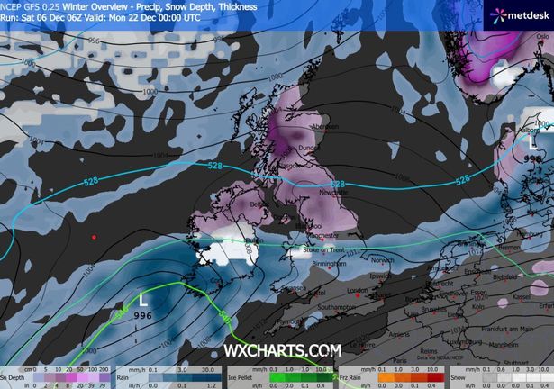 Snow coverage map for December 22(Image: WX Charts)
“Having said that, there are some hints that the pattern could change by January, with indications that the NAO may switch from positive to negative.
“In other words, we could see high pressure starting to develop in the vicinity of Iceland and Greenland instead of low pressure. If that were to occur then we could see a change in weather type, with a growing chance of colder weather.
“The situation is complicated by disturbances in the upper atmosphere that might have an impact on the northern hemisphere’s circulation in three to four weeks time.”