
NASA’s Mars Reconnaissance Orbiter (MRO) has made a historic leap in its mission to understand the Red Planet. With its HiRISE camera now having captured its 100,000th image, this milestone provides an unprecedented view of Mars. The detailed visuals from HiRISE are crucial not just for science, but for future human exploration of the planet. The images, including one taken in October 2025, reveal key Martian features, advancing our knowledge of Mars’ landscape and atmosphere.
The Power of HiRISE: NASA’s Eyes on Mars
For nearly two decades, NASA’s Mars Reconnaissance Orbiter has been orbiting Mars, capturing some of the most detailed images of the Martian surface ever taken. At the heart of this mission is the HiRISE camera, an incredibly high-resolution imaging instrument that provides unmatched clarity. These images are more than just beautiful snapshots; they offer invaluable scientific insights into Mars’ complex environment. The milestone of 100,000 images isn’t just a number—it represents the tireless efforts of scientists and engineers working to decode Mars’ mysteries.
The images taken by HiRISE allow scientists to observe a wide range of Martian features, from towering cliffs and valleys to vast sand dunes and ancient crater basins. Each image contributes to a greater understanding of the planet’s geology, weather, and history, all of which are crucial for future missions. By examining these images, scientists can map out landing sites for future rovers or even humans, offering the foundation for the next big leap in space exploration. As Leslie Tamppari, MRO’s project scientist, explains,
“HiRISE hasn’t just discovered how different the Martian surface is from Earth, it’s also shown us how that surface changes over time.”
A Window to the Martian Landscape: The 100,000th Image
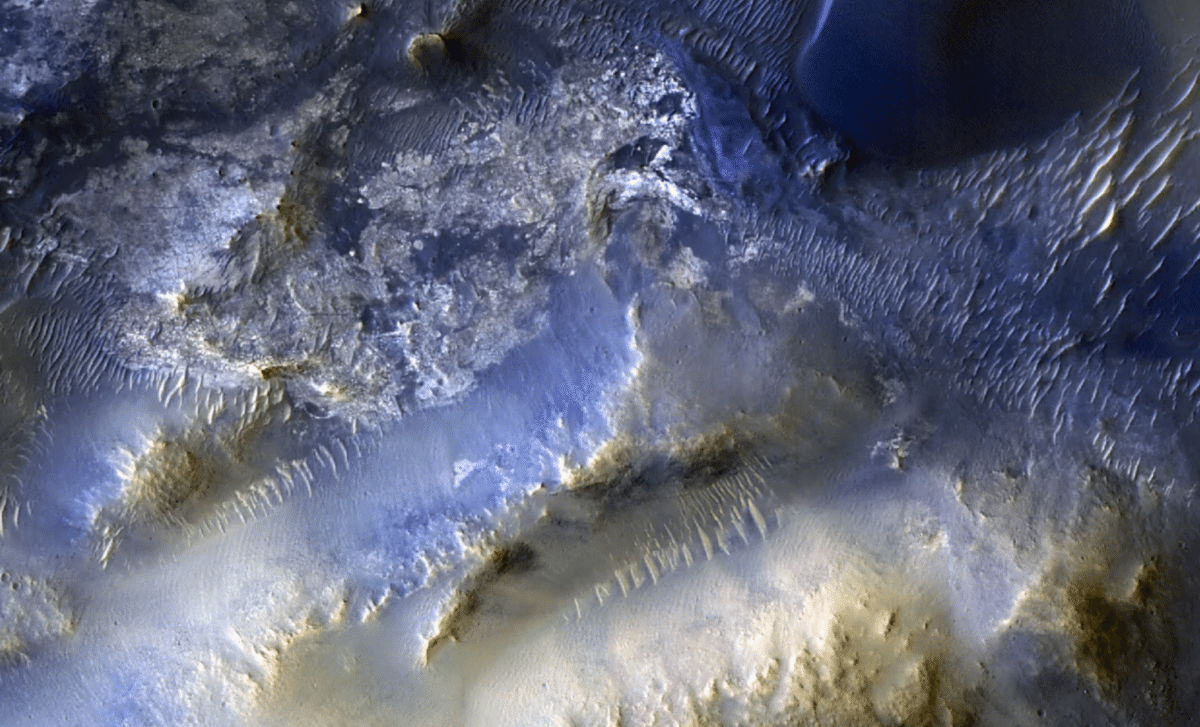
The 100,000th image, taken on October 7, 2025, showcases the dramatic landscape of Syrtis Major, a large region on Mars about 50 miles southeast of Jezero Crater. This region has been the subject of intense scientific interest because of its varied terrain, which includes mesas, dunes, and other features shaped by wind and water. The image is more than just a visual spectacle; it provides key insights into the movement of windblown sand that has shaped the region’s topography over millions of years.
Scientists are particularly excited about this image because it allows them to study the formation of sand dunes in a region where the dynamics of the Martian atmosphere have been constantly at play. As the wind blows across the landscape, it moves sand and debris, creating striking patterns of dunes and revealing the forces at work on Mars’ surface. According to MRO’s project scientist, Leslie Tamppari, “We’ve seen dune fields marching along with the wind and avalanches careening down steep slopes.” These findings are critical for understanding not only the geology of Mars but also the climatic and atmospheric processes that govern the planet.
Public Involvement: A Key Element in HiRISE’s Success
One of the most exciting aspects of HiRISE’s work is the involvement of the public. Through the HiWish program, anyone can suggest areas of Mars that they would like to see photographed. This collaboration between scientists and the broader public has led to some of the most interesting and unique images captured by the HiRISE camera. The 100,000th image was one such case, recommended by a high school student through this initiative.
Shane Byrne, the principal investigator of the HiRISE camera at the University of Arizona, explains,
“Rapid data releases, as well as imaging targets suggested by the broader science community and public, have been a hallmark of HiRISE. One hundred thousand images just like this one have made Mars more familiar and accessible for everyone.”
The HiWish program has democratized space exploration in a way that allows people from all over the world to engage with NASA’s Mars exploration efforts, fostering a global interest in the Red Planet.
The Role of HiRISE in Future Mars Missions
As NASA looks towards future missions, including the potential for human exploration of Mars, HiRISE will continue to play a crucial role. The camera’s high-resolution imaging allows mission planners to better understand the Martian environment, helping to identify potential hazards and select ideal landing sites for both robotic and human exploration. For example, the detailed images of Syrtis Major could one day help astronauts navigate the planet’s surface, avoiding danger while taking in the awe-inspiring views of the Martian terrain.
The insights provided by HiRISE are not just useful for the current generation of scientists but will lay the groundwork for future missions. Understanding Mars’ surface and atmosphere is essential for ensuring the safety and success of astronauts who will venture to the planet in the coming decades. As MRO’s scientists continue to capture detailed images of Mars, they help build a roadmap for the next steps in space exploration, pushing the boundaries of what is possible in our search for life beyond Earth.