

The Met Office has warned some areas could see gusts of 85mph
11:49, 01 Aug 2025Updated 11:51, 01 Aug 2025
 Unseasonably strong winds are set to hit Northern parts of the UK next week(Image: Manchester Evening News)
Storm Floris is set to hit the UK next week, bringing a spell of unusually windy weather for the time of year across the northern half of the UK.
The strongest winds are most likely to occur across Scotland during Monday afternoon and night, although there remains some uncertainty in the depth and track of Floris.
Storm Floris is the sixth named storm of the 2024/2025 Storm Naming season and will see many inland areas affected likely to see westerly wind gusts of 40-50 mph with 60-70 mph possible along exposed coasts and high ground, especially Scotland.
There is a chance of a spell of even stronger winds developing for a time, with inland gusts of 60-70 mph and 85 mph along exposed Scottish coastlines and hills.
Winds will first ease in the west during later Monday but remaining very strong overnight until early Tuesday in the east. Heavy rain may also contribute to the disruption in places.
The Met Office has now issued a 24-hour yellow weather warning for wind from 6am on Monday morning.
The warning zone covers Scotland, parts of Northern Ireland, north Wales and the north of England.
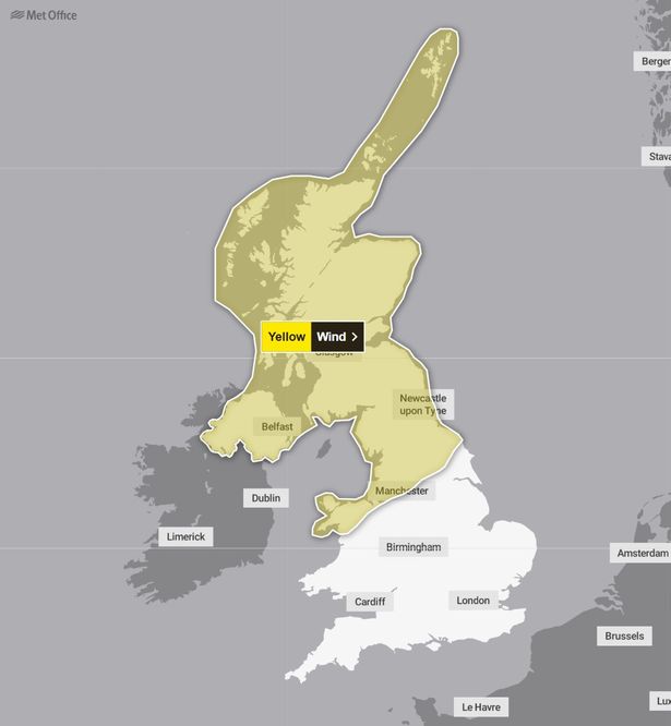 A map showing the Met Office weather warning area
Flying debris may cause injuries and pose a danger to life in those areas.
As could “large waves and beach material being thrown on to sea fronts, coastal roads and properties”, the Met Office said.
It is possible tiles will be blown from roofs and there may be power cuts.
The weather could also disrupt road, rail, air and ferry services, and close bridges. Here are all the regions which are covered by the yellow Met Office weather warning on Monday and Tuesday.
Regions and local authorities affectedCentral, Tayside & FifeAngusClackmannanshireDundeeFalkirkFifePerth and KinrossStirlingGrampianAberdeenAberdeenshireMorayHighlands & Eilean SiarNa h-Eileanan SiarHighlandNorth East EnglandDarlingtonDurhamGatesheadHartlepoolMiddlesbroughNewcastle upon TyneNorth TynesideNorthumberlandRedcar and ClevelandSouth TynesideStockton-on-TeesSunderlandNorth West EnglandNorthern IrelandCounty AntrimCounty ArmaghCounty DownCounty FermanaghCounty LondonderryCounty TyroneOrkney & ShetlandOrkney IslandsShetland IslandsSW Scotland, Lothian BordersDumfries and GallowayEast LothianEdinburghMidlothian CouncilScottish BordersWest LothianStrathclydeArgyll and ButeEast AyrshireEast DunbartonshireEast RenfrewshireGlasgowInverclydeNorth AyrshireNorth LanarkshireRenfrewshireSouth AyrshireSouth LanarkshireWest DunbartonshireWalesConwyDenbighshireFlintshireGwyneddIsle of AngleseyYorkshire & HumberEast Riding of YorkshireNorth YorkshireWest YorkshireYork
Matthew Lehnert, Met Office Chief Meteorologist, said: “Across the warning area, many inland areas are likely to see gusts of 40-50mph, with 60-70mph more likely at higher elevations and around exposed coasts in Scotland.
“There is a small chance that some locations here could even record gusts of 85mph.”
The Met Office is advising you prepare to protect your property and people from injury by checking for loose items outside your home and planning how you could secure them.
It is also advising you avoid delays by checking road conditions if driving, or bus and train timetables, amending your travel plans if necessary.
There may also be power cuts caused by the winds, so those affected are advised to consider gathering torches and batteries, a mobile phone power pack and other essential items.
It is also warning that strong winds near the coast may cause large waves, which can sweep you off your feet and out to sea. In an emergency, call 999 and ask for the Coastguard.