
Communities in the Northern Territory are bracing as Tropical Cyclone Narelle hurtles through the Gulf of Carpentaria towards the coastline.The weather system crossed Far North Queensland as a category 2 storm but is expected to intensify up to a category 3 cyclone again before making landfall in the Top End.
It’s forecast to cross the coast as a severe tropical cyclone, somewhere between Birany Birany and Numbulwar, in the early hours of Sunday morning.
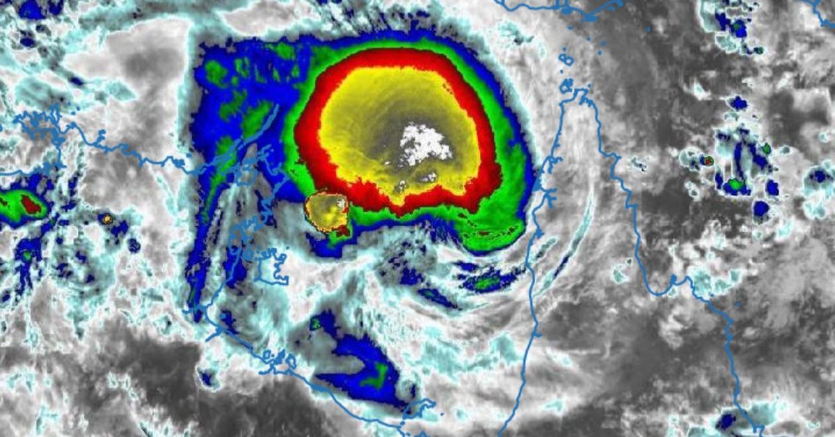
 Communities in the Northern Territory are bracing as Tropical Cyclone Narelle hurtles through the Gulf of Carpentaria towards the coastline. (Bureau of Meteorology)
The warning zone extends from Nhulunbuy to Port McArthur, including Borroloola, Numbulwar, Alyangula, and Gapuwiyak, where life-threatening flash flooding is likely.
They cyclone’s moving at 19km/h and is currently sitting 155 kilometres west-southwest of Weipa and 455 kilometres east of Alyangula.
It’s still at a category 2 level, with sustained winds near the centre of 100km/h and wind gusts of up to 140km/h.
Meteorologist Angus Hines said this means more heavy rain for areas already impacted by significant flooding in recent weeks.
“We could see rainfall in excess of 100 to 200 millimetres along the path of that tropical cyclone, stretching from Alyangula on the east coast to the Katherine area, and out to Wadeye on the western side of the Top End,” Hines said.
 It’s forecast to cross the coast as a severe tropical cyclone, somewhere between Birany Birany and Numbulwar, in the early hours of Sunday morning. (Bureau of Meteorology)
“These rainfall numbers are significant, with isolated values above that during Sunday and into early Monday morning, and are likely to lead to renewed river rises across the top end, including the potential for renewed major flooding around Katherine and Beswick, and prolonged major flooding around the Daly River.”
Heavy rain and strong winds will then reach the northern Kimberley, Kalumburu and areas north of Kununurra early next week.
Premier David Crisafulli told 9News emergency services were ready to help as Narelle headed straight for Aurukun, an Indigenous community home to about 1200 people.
“It threaded the needle on the east coast (this morning), right between Coen and Lockhart River, which was tremendous,” Crisafulli said.
“Whilst it has slowed in intensity, there is that prospect of those strong winds and we’re starting to get reports of that happening right now in Aurukun.
 A tree has fallen on a home in Coen. (Nine / Supplied)
“So we’re keeping a watching brief of Aurukun, Weipa on the western side, and obviously the rain that will come from it as well.”
Aurukun and surrounding areas were bracing for destructive wind gusts up to 150km/h, while Weipa and surrounds were anticipating gusts up to 120km/h.
Archer River, north of Coen, recorded 400 millimetres of rain in less than 24 hours as the eye of the tropical cyclone passed over Cape York.
“We saw the bridge, the water under the bridge go from five metres to 13 metres in a handful of hours, that is big rain,” Crisafulli told 9News.
“What’s important now is that there’s no daylight between response and recovery.
“As the system goes to the west we are already on the ground reconnecting power, making sure that there’s infrastructure there, we’ve pre-positioned people.”
Cyclone dodges biggest targets as it makes landfall
Narelle made landfall north-east of Coen about 8am (9am AEDT) and began tracking west across the Cape York Peninsula.
Affected towns in Far North Queensland received more than 100 millimetres of rain in 24 hours, some copping up to four times that.
The Bureau of Meteorology’s flood watch for North Queensland on Friday covered the entire peninsula from the Herbert River up through the rivers, creeks and streams across the Cape.
 The Archer River Crossing as of midday on Wednesday. (Department of Transport and Main Roads, Queensland)
 The Archer River Crossing as of midday on Friday, showing significant river rise and flooding. (Department of Transport and Main Roads, Queensland)
There were no reports of fatalities or serious injury, according to the Queensland Ambulance Service.
Hundreds of homes were without power, particularly in Coen and Lockhart River, where authorities warned of fallen powerlines.
A strong storm surge pushed waves onto paths and coastal roads as far south as Cairns, dragging trees, paths and benches into the ocean.
Emergency crews took to the streets as soon as it was safe to begin the clean up, but many roads have been cut by floodwater and fallen trees.
NEVER MISS A STORY: Get your breaking news and exclusive stories first by following us across all platforms.