
A vast freshwater reservoir has been detected beneath Utah’s Great Salt Lake, reaching depths of up to 2.5 miles. Early data suggest it could be as large as the lake itself. The discovery comes as the Great Salt Lake continues to shrink, exposing dry land and raising concerns about toxic dust.
Beneath this changing landscape, scientists have now confirmed the presence of fresh water where only salt was expected. For years, unusual patches of vegetation hinted that something was happening underground. This study finally connects the dots and gives scientists a clearer view of what lies beneath the lakebed.
A Helicopter Survey Reveals What Lies Below
To understand where the freshwater was coming from, a team led by Michael Zhdanov at the University of Utah carried out an airborne electromagnetic survey over about 10 square miles (25 square kilometers) of the lake. As explained in a study, published in Scientific Reports, a helicopter flew back and forth with a device that sent signals into the ground and measured what bounced back.
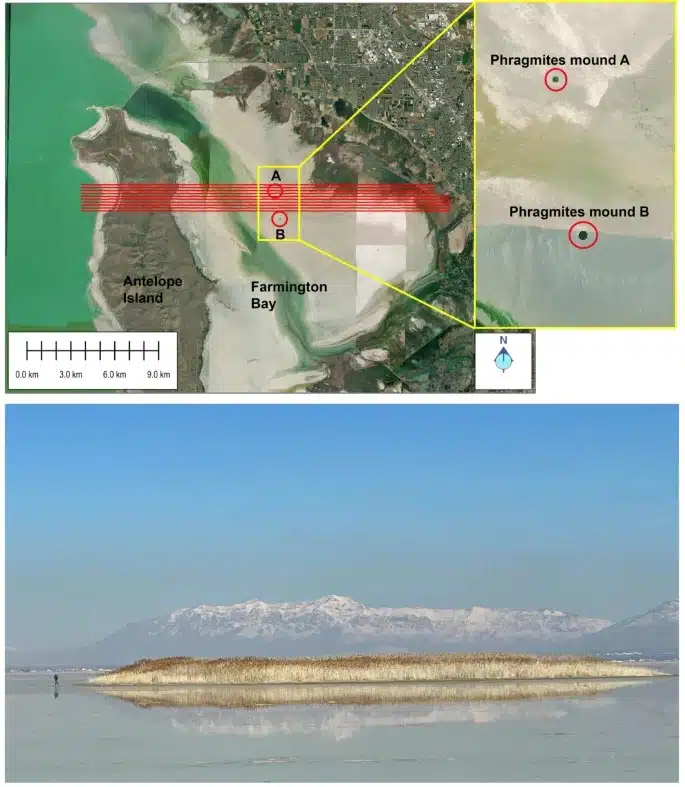 Survey lines and reed-covered mounds reveal the location of a hidden freshwater reservoir beneath the Great Salt Lake. Credit: Scientific Reports
The idea was simple. Saltwater and freshwater do not conduct electricity the same way. Even with the lake’s high salinity, the method worked. The data showed a continuous freshwater reservoir layer stretching from about 330 feet (100 meters) down to 2.5 miles (4 kilometers).
“When I first realized that we found this, I was very excited.” said Zhdanov. “We were able to answer the question of how deep is this potential reservoir, and what is its spatial extent beneath the eastern lake margin. If you know how deep, you know how wide, you know the porous space, you can calculate the potential freshwater volume.”
Water Stored For Thousands Of Years Underground
The freshwater did not appear overnight. The latest research suggests it likely originates from snowmelt in the surrounding mountains, gradually seeping into the ground over thousands or even millions of years.
What keeps it separate from the salty lake above is geology. Layers of impermeable rock act as barriers, trapping the freshwater below. The study also points to faults in the underlying rock, which may explain why the reservoir is deeper in some places than others.
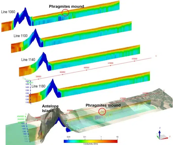 Subsurface data reveals a freshwater reservoir beneath the Great Salt Lake. Credit: Scientific Reports
In a few spots, the reservoir water seems to rise closer to the surface. That is exactly where dense reeds, known as phragmites, have been growing, one of the first clues that freshwater was present.
A Possible Fix For The Lake’s Crisis
The timing of the reservoir discovery matters. The Great Salt Lake has dropped by about 22 feet (6.7 meters) since 1986, driven by drought, climate conditions, and water use. This has exposed large areas of dry lakebed that can release toxic dust into the air, affecting nearby communities like Salt Lake City.
Researchers say that, if the freshwater extends across a wider area, it could help keep some of that land moist and reduce dust spread. There is also the question of whether it could be used for irrigation, though that remains uncertain for now.
“There are beneficial effects of this groundwater that we need to understand before we go extracting more of it. A first-order objective is to understand whether we could use this freshwater to wet dust hotspots and douse them in a meaningful way without perturbing the freshwater system too much,” explained Bill Johnson, a hydrologist involved in the groundwater study.
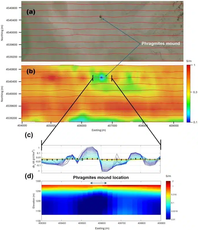 Multi-panel data identifies a low-conductivity anomaly beneath the mound. Credit: Scientific Reports
The analysis is based on a limited area, so more work is needed to determine how far this hidden reservoir actually stretches.
“This is why we need to survey the entire Great Salt Lake. Then we’ll know the top and the bottom,” Zhdanov noted. “To study the top we use airborne electromagnetic methods, which gives us the thickness of the saline layer and where the freshwater starts under the saline layer. To study the bottom, we use magnetic data.”