
A huge upstream basin of rainwater and snowmelt dammed by Alaska’s Mendenhall Glacier started to release on Tuesday, as officials urged residents in some parts of the state capital of Juneau to evacuate ahead of an anticipated surge of floodwater.
The National Weather Service’s Juneau office issued a flood warning for parts of the area around the Mendenhall River near Auke Bay. The water that’s being released in the so-called glacial outburst is flowing into the river, putting homes that are closest to the river at risk.
As of Tuesday afternoon local time, the water level was at 9.85 feet; major flooding is considered at 14 feet. A “crest” is expected sometime Wednesday afternoon near record levels between 16.3 and 16.8 feet, the NWS said.
“This will be a new record, based on all of the information that we have,” Nicole Ferrin, a weather service meteorologist, said Tuesday during a news conference.

A view of the Mendenhall Glacier Suicide Basin area in Juneau, Alaska vicinity late on August 11, 2025/
National Weather Service
Officials in recent days have been warning people in the flood zone to be ready to evacuate. On Tuesday morning, they confirmed water had started escaping the ice dam and was flowing downstream, with flooding expected late Tuesday and on Wednesday. They advised people in the city’s flood zone to leave while saying there was no need to rush.
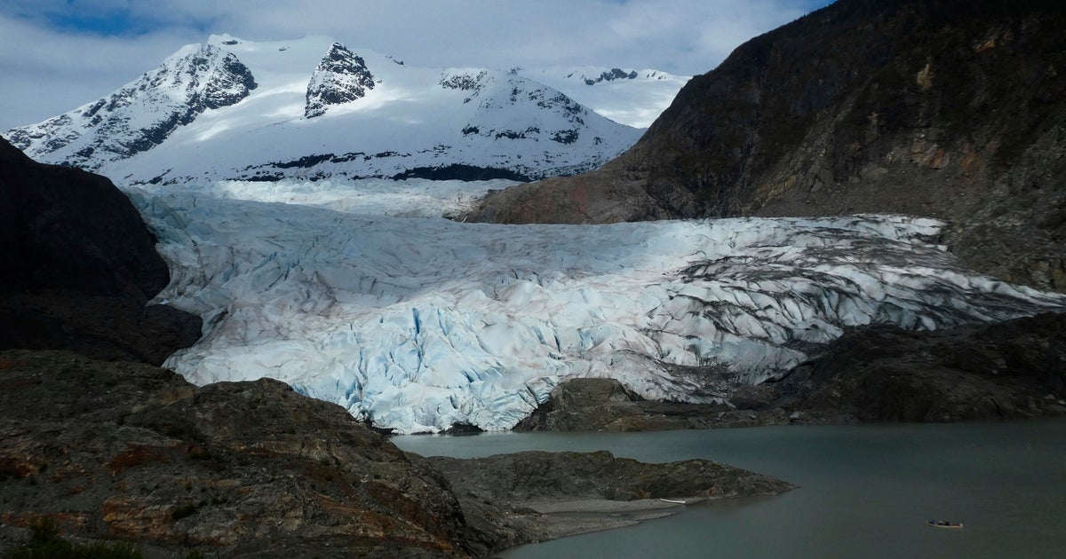
The Mendenhall Glacier is about 12 miles from Juneau and is a popular tourist attraction due to its proximity to Alaska’s capital city and easy access on walking trails. Homes on the city’s outskirts are within miles of Mendenhall Lake, which sits below the glacier, and many front the Mendenhall River.

A canoe, bottom right, glides on Mendenhall Lake, in front of the Mendenhall Glacier, on Sunday, May 18, 2025, in Juneau, Alaska.
Becky Bohrer / AP
Mendenhall Glacier acts as a dam for Suicide Basin in Alaska
The thinning, retreating glacier in southeast Alaska acts as a dam for Suicide Basin, which fills each spring and summer with rainwater and snowmelt. The basin itself was left behind when a smaller glacier nearby retreated.
When the water in the basin builds up enough pressure, it forces its way under or around the ice dam, entering Mendenhall Lake and eventually the Mendenhall River, which runs along several neighborhoods in part of Juneau.
Before the basin reached the limit of its capacity and began overtopping over the weekend, the water level was rising rapidly — as much as 4 feet per day during especially sunny or rainy days, according to the NWS.

HESCO flood barriers, to protect property against glacial outburst flooding, separate a residential area from the Mendenhall River, Sunday, Aug. 3, 2025, in Juneau, Alaska.
Marc Lester/Anchorage Daily News via AP
The threat of glacier outburst flooding has troubled parts of Juneau since 2011. In some years, there has been limited flooding of streets or properties near the lake or river.
Flooding from the basin has become an annual concern, and in recent years has swept away houses and swamped hundreds of homes. Government agencies installed a temporary levy this year in the hope of guarding against widespread damage.
Video posted on social media two years ago showed towering trees behind a home falling into the rushing Mendenhall River as the water ate away at the bank. Eventually, the home, teetering at the edge, also collapsed into the river.
Alaska Gov. Mike Dunleavy on Sunday issued a state disaster declaration as a result of the “imminent threat of catastrophic flooding from a glacier lake outburst flood (GLOF)” in the Juneau area. The declaration follows joint local disaster declarations and requests for assistance from the city and borough of Juneau, and the Tlingit and Haida Indian Tribes of Alaska, according to a news release.
More from CBS News