
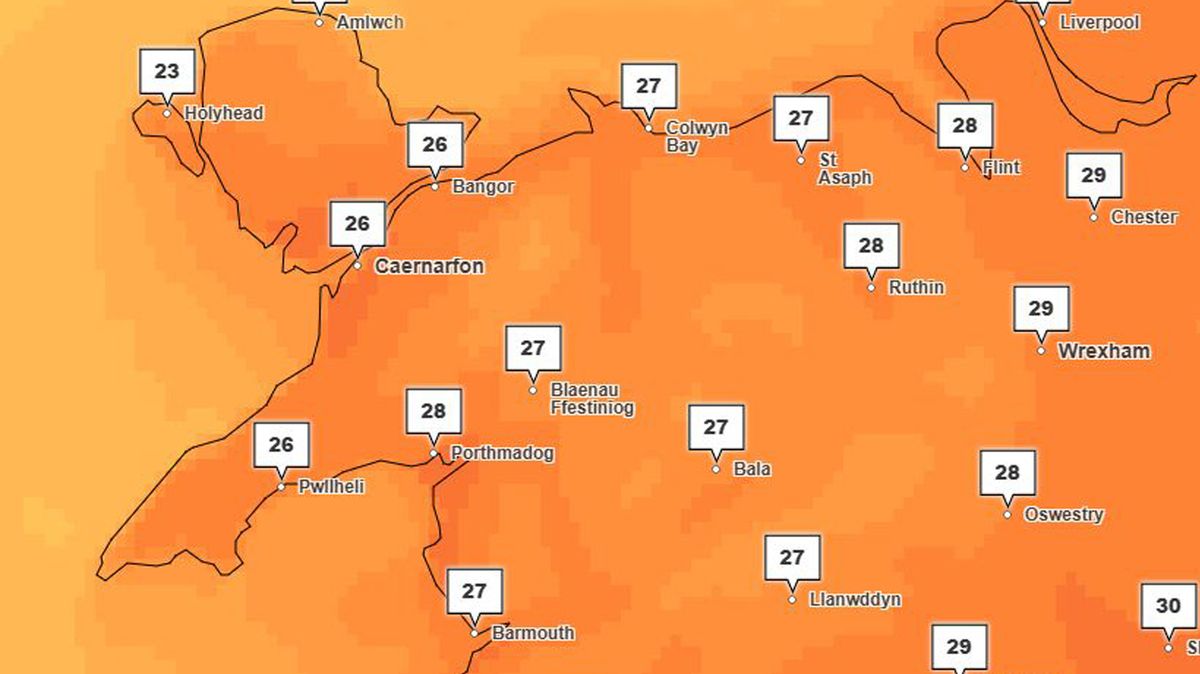
A heatwave across Wales now looks increasingly likely in updated Met Office forecasts. Highs of 29C are expected in North Wales and there is an outside chance the country’s June temperature record could fall.
Monday, June 22, is forecast to be the hottest of the current spell with the mercury rising to at least 28C just about everywhere in the region. Met Office maps also indicate a run of at least six days with temperatures exceeding 25C in much of North Wales.
The forecaster classifies a heatwave as three consecutive days where temperatures meet or exceed a threshold value. In Wales that threshold is 25C, meaning many areas could officially enter heatwave conditions by Tuesday evening June 23.
Intensifying heat flooding up from the Continent is forcing the Met Office to constantly update its temperature forecasts. The UK Health Security Agency (UKHSA) is also upgrading its warnings, having now issued an Amber heat health alert ahead of the potential heatwave.
This covers the east, south-east and south-west of England, and is valid from 12pm today (Thursday) until 8pm on Tuesday. Yellow alerts are also in force across the Midlands during the same period.
With temperatures set to reach 34C in London on Monday, the Met Office said: “There is currently a 40% chance of exceeding the current UK June maximum temperature record of 35.6C, set in 1957 and 1976.
“There is also a lower chance of exceeding the June maximum temperature record for Wales.” This was set in Machynlleth, Powys, in 2000, when thermometers recorded 33.7C (92.6F). Sign up for the North Wales Live newsletter sent twice daily to your inbox
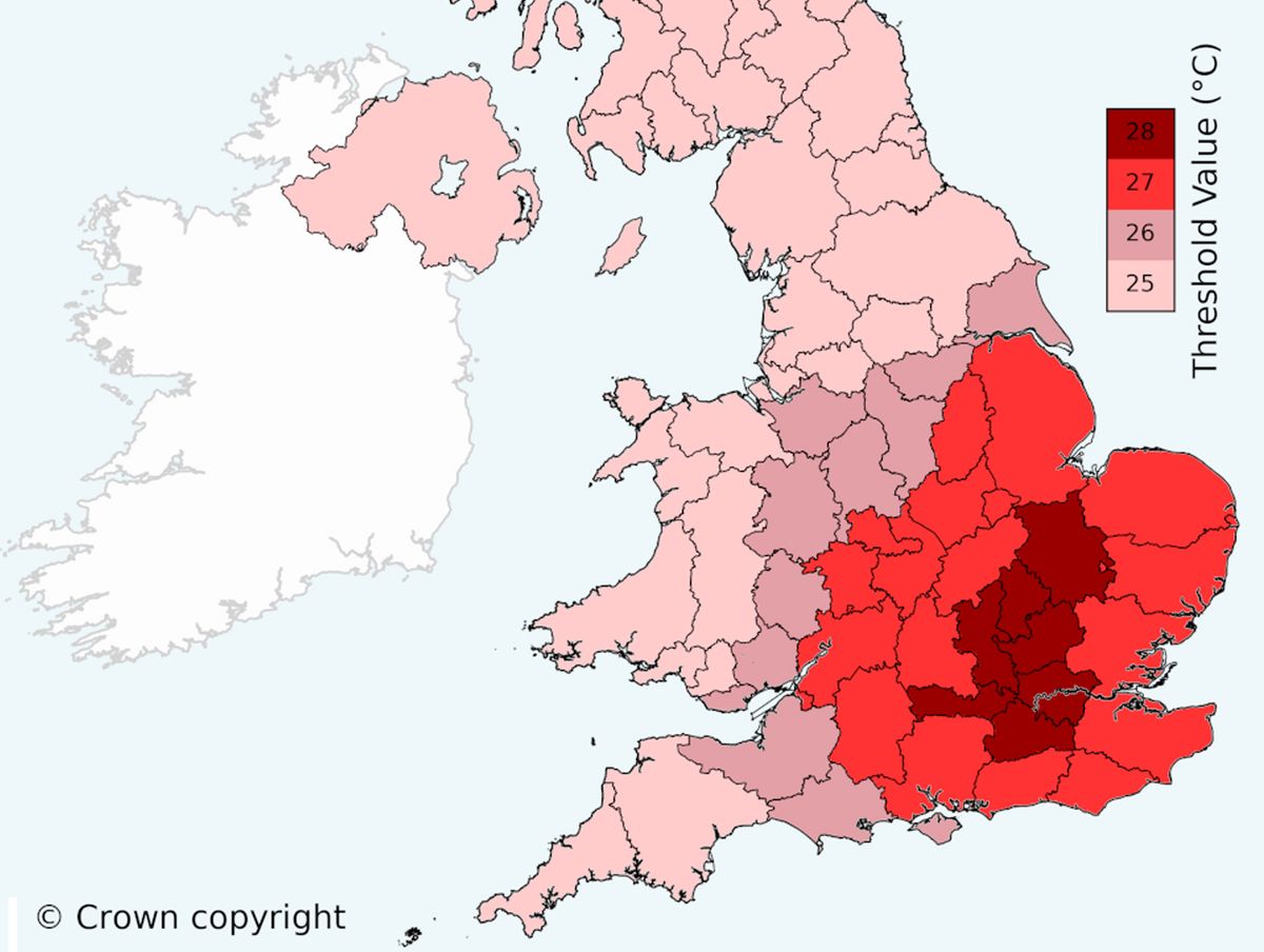
Temperature thresholds across the UK which must be exceeded for three successive days for a heatwave to be declared(Image: Met Office)
Last month, May temperatures records tumbled in Wales during what the Met Office called an “unprecedented heatwave”
On May 26, a new May high of 32.6C was recorded in Cardiff Bute Park. Meanwhile, Aberdaron on the Llŷn Peninsula, Gwynedd, was the balmiest place in the country, with the highest Wales daily minimum ever recorded in May: on May 26, temperatures in the coastal village never went below 18.9C.
Next Monday, Cardiff is expected to hit 30C and southeast Wales could see these kind of temperatures for several successive days.
In North Wales, the Met Office expects south Gwynedd to see highs of 29C on Monday in places like Dolgellau, Barmouth and Aberdyfi. The same peak is predicted for Wrexham.
Coastal resorts everywhere are likely to be busy as visitors head to the seaside, with the mercury rising to 27C-28C in the likes of Llandudno, Rhyl and Colwyn Bay.
Mountain summits could offer some relief, peaking at 21C-22C on Yr Wyddfa and Cader Idris. Already the summer, local mountain rescue teams have warned walkers of the need to go properly equipped for warm weather, especially if they have dogs.
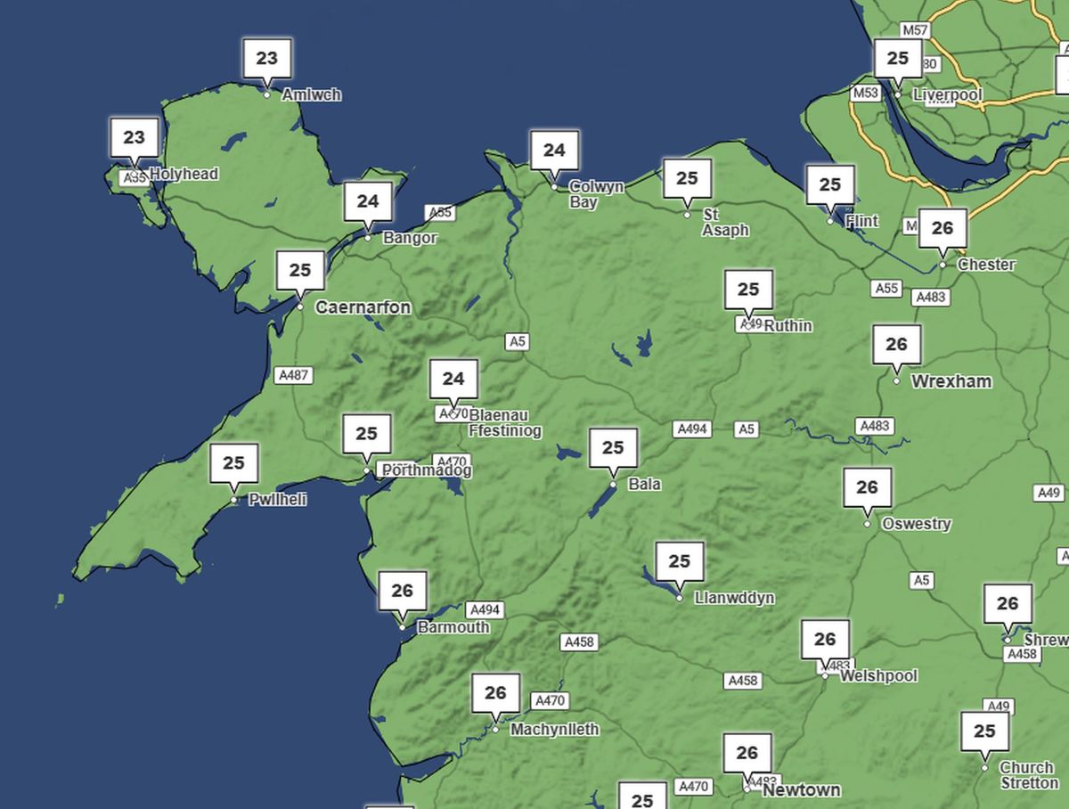
Temperatures are currently forecast to remain high in North Wales all next week – these are the figures for Friday, June 26(Image: Met Office)
How long the heat persists, and how far it extends across the UK, is still being assessed by the Met Office. Much depends on the position of low pressure to the west of Britain.
Current Met Office forecasts show temperatures remaining in the mid to high 20Cs across North Wales until at least Friday, June 26. If the Atlantic low moves towards the UK, these figures are likely to be revised downward.
If the low stays put and intensifies, dragging more heat up from the Continent, forecasts may be revised upwards.
Gregory Wolverson, Deputy chief forecaster, at the Met Office, said: “It’s important to note that while temperatures may be high, we might not all see the wall-to-wall sunshine and blue skies we experienced back in late May because there may be more cloud around.
“Couple this with fairly high humidity, and it may feel rather oppressive at times. There is also a chance of thunderstorms developing in places, which could bring heavy downpours and localised impacts.”