
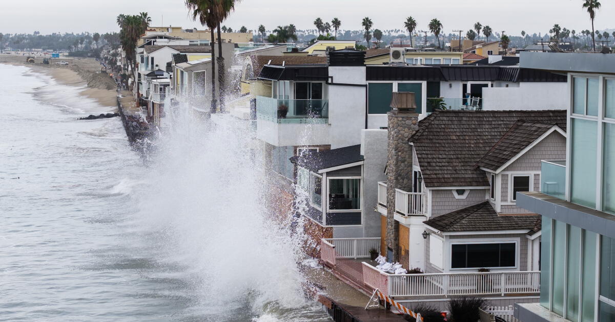
Post-Tropical Cyclone Rachel was moving into Baja California as Southern California braced for rain and potential coastal flooding on Sunday.
The National Weather Service said Southern California can expect increasing rain and strong, damaging waves along the coast early Sunday as Rachel moves through Baja and into the southwest United States.
Rachel is one piece of a highly unusual combination of events that underscores the challenges California is facing amid predictions of a “super” El Niño winter.
The conditions led to coastal flooding that damaged homes and flooded roads this week from Newport Beach to Long Beach in recent days. Those areas are now bracing for more impact.
The flooding was extraordinary, and scientists said they show how Rachel, along with high tides, a record-hot ocean and El Niño-fueled waves, can overwhelm coastal areas.
“The combination of high tides, Kelvin wave, hurricane waves — and then a whole summer worth of that? This is unprecedented,” said Jonathan Warrick, a research geologist with the U.S. Geological Survey. “And this is what we got to look forward to in the future,” with a long El Niño season ahead, and the possibility of a relentless parade of winter storms and king tides during the holiday season.
The center of Rachel made landfall in northern Baja California Saturday night, and by 11 p.m., was about 90 miles southeast of San Diego and 25 miles southeast of Ensenada. Rachel had maximum sustained winds of 60 mph, the National Hurricane Center said.
Overnight, the National Weather Service issued a flash flood warning in parts of San Diego, Riverside and Imperial counties, including a swath of the Coachella Valley, as well as the cities of El Cajon, Santee and Blythe, warning that flash flooding was occurring or expected to begin shortly. At 1:17 a.m., radar indicated intense rain in the Coachella Valley, including southeastern Palm Springs, Coachella, Palm Desert, Indio and Rancho Mirage, with rainfall rates of three-quarters of an inch to one inch per hour.
“Bands of torrential rainfall and severe thunderstorms are occurring from California’s Imperial Valley eastward into Arizona, with serious flash flood threat,” UC Agriculture and Natural Resources climate scientist Daniel Swain said on social media. Tropical-like showers and thunderstorms on Rachel’s eastern side could drop as much rainfall as the area gets in one to two years “in some of the driest desert regions in North America!”
On the Southern California coast, the weather service’s San Diego office said Sunday morning would carry the highest flooding risks along Orange County and San Diego County coast as swells, onshore winds and high tides combine. High tide on Sunday morning is at 9:43 a.m. in La Jolla and 9:48 a.m. in Newport Beach.
High tide Sunday morning in Los Angeles County is around 9:49 a.m. The weather service’s Oxnard office warned that south-facing beaches of Los Angeles County could experience the worst coastal flooding of the season — exceeding the considerable damage caused by swells from a distant Hurricane Marie over Labor Day weekend, which damaged homes on the Long Beach Peninsula and in Malibu and Dana Point.
“Localized damaging sea-water flooding is likely, especially Long Beach, Avalon, Malibu,” the weather service’s Oxnard office said. “Significant beach erosion likely.”
Coastal flood warnings or advisories stretched up the California coast from San Diego to Santa Cruz, and encircled much of San Francisco Bay. Forecasters also warned of a risk of flooding in Southern California’s mountains and deserts from the rain.
By Saturday night, Long Beach reported that seawater had entered homes and into streets, with the city’s Peninsula neighborhood being hard hit, and its boardwalk crumbling. The bulkhead that protects beachfront homes was overtopped by waves and was significantly damaged on Seaside Walk between 64th Place and 66th Place, the city said in a statement. A crane was deployed to help position 30 heavy-duty sandbags, each weighing 3,000 pounds, to reinforce the bulkhead at 64th Place.
A mandatory evacuation order was issued on Friday on the Long Beach Peninsula for a few homes on Seaside Walk, between the 64th and 66th blocks. On Saturday, an evacuation warning was issued for homes on 64th, 65th and 66th places south of Ocean Boulevard, and for homes in the 6200, 6300, 6600 and 6700 blocks of Seaside Walk. An evacuation advisory was in place for all of Naples Island, Treasure Island and all other residents of the Peninsula.
Warrick and others say this week’s events could offer clues to next season.
“I won’t say 100% sure we’re going to see this this winter, but this is a type of thing we may see a lot more of this winter,” Warrick said. “And then looking forward into the coming decades with continued sea level rise, this is exactly the type of event that will be seeing a lot more of in the coming decades.”
The highest high tides of the year hit California roughly around the summer and winter solstices. Some are expected on Thanksgiving Day, Christmas Eve and Jan. 22. Should they coincide with strong winter storms, coastal erosion, flooding and damage are likely, according to Reinhard Flick, a researcher at the UC San Diego Scripps Institution of Oceanography.
Roughly every 18.6 years and every 4.4 years, the tides are especially big. And we are near the peaks of those cycles. “That means that around Christmastime, California will see some very strong king tides that will superpose on the high sea levels caused by El Niño,” said Mark Merrifield, director of the Scripps’ Center for Climate Change Impacts and Adaptation, earlier this year.
El Niño is a climate pattern marked by unusual warmth in the central and eastern equatorial Pacific Ocean, and results in changes to the atmosphere that, typically, lead to above-average precipitation in Southern California.
Two of the strongest El Niños in the last 75 years were associated with extensive damage to the Southern California coast, battering homes, flooding streets and damaging piers. Another one did not result in above-average rain, but did cause record coastal erosion.
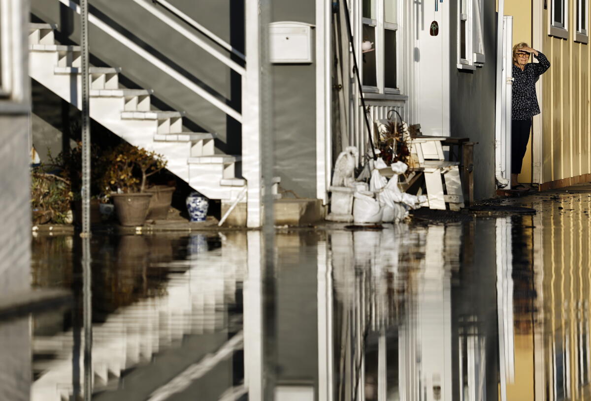
A Long Beach resident stands by coastal floodwaters amid strong waves and high tides generated by Tropical Storm Rachel.
(Mario Tama / Getty Images)
This week’s flooding seen in Orange County is likely the result of not only swells from Rachel, which was once a hurricane, but also the recent arrival of an El Niño-fueled Kelvin wave that moved slowly up the coast of the Americas from Peru, at a speed of about 6 miles per hour. It’s not the kind of wave that can be surfed or obviously seen at the surface, but it can raise background sea levels by perhaps 6 to 12 inches, bringing along warmer waters that — because hotter water takes more volume — increase the sea level.
“I mean, I grew up down there. I was on Newport Beach every day, you know, when I was a kid, and I’ve never seen anything like this. This is completely unprecedented. It’s shocking,” Warrick said.
This Kelvin wave could keep sea levels elevated for months before its effects fade. And there’s already another Kelvin wave that he’s monitoring that’s coming up the coast of Mexico, said Dillon Amaya, an expert on Kelvin waves and an assistant professor at North Carolina State University’s Department of Marine, Earth and Atmospheric Sciences. It’s at least a few weeks away from Southern California.
The leading edge of the current Kelvin wave has already passed L.A. as well as San Francisco.
“The hurricane is definitely the triggering factor in terms of providing the storm surge, but the Kelvin wave almost certainly conditioned the background sea state such that flooding was more dangerous this time,” said Amaya, who got his doctorate in oceanography at the Scripps Institution of Oceanography at UC San Diego.
City officials have been frantically preparing for Rachel, building sand berms and fortifying vulnerable areas with sandbags.
Water at the Los Angeles Harbor tide gauge peaked at 7.7 feet Saturday morning, about 1.6 feet above the predicted tide, the National Weather Service said. “The projected high tides of around 8 feet for Sunday morning would approach or exceed recent record tide levels for L.A. County,” it said.
Just in late August, tides were coming in at about 5 inches above the official forecast in Santa Monica. Last week, they came in at 11 inches above the forecast. On Saturday night, the tide was coming in 20 inches above forecast.
And in San Francisco, tides were coming in at 10 inches above expectation at the beginning of the month; as of Saturday, they were coming in at 17 inches above the forecast. The increase in the tide in San Francisco, Amaya said, is consistent with the expected influence of a Kelvin wave.
In the modern record, only two storms have passed through or just offshore of the state at tropical-storm strength.
The first — nicknamed El Cordonazo, or the Lash of St. Francis — hit Long Beach and San Pedro in September 1939. It dumped 5.62 inches of rain on L.A. over three days, spawned wind gusts of up to 65 mph and resulted in 45 deaths from flooding, with an additional 48 deaths at sea.
In September 1997 there was also Nora, which was briefly at tropical storm strength as its center passed along the California-Arizona border, but California was spared the kind of damage it delivered to Baja California.Street flooding was reported in Imperial County, the Coachella Valley and San Diego, while big waves boosted by Nora and another storm sent breakers crashing into beachfront properties in Seal Beach, seriously damaging three homes and resulting in minor damage to 45 others.
Nora arrived during a “very strong” El Niño season. El Niño is linked to above-average hurricane activity in the eastern Pacific.
The National Oceanic and Atmospheric Administration’s Climate Prediction Center said Thursday that there is virtually a 100% chance that the El Niño this season will be categorized as “very strong.” There’s also an 83% chance that this El Niño will be the strongest on record, which goes back to 1950, up from a 75% probability forecast last month.
Times staff writers Jasmine Mendez, Hannah Fry and Jaweed Kaleem contributed to this report.