
In a striking image recently shared by the European Space Agency (ESA), a landscape of Saudi Arabia’s barren desert reveals the fascinating yet subtle pattern of circular agricultural structures. Captured by the Copernicus Sentinel-1 satellite, these circles represent an innovative and vital irrigation technique in the heart of one of the world’s most arid regions. The image showcases how modern technology, combined with sustainable water management practices, is transforming the landscape of northern Saudi Arabia, making it one of the rare places on Earth where agriculture thrives despite the harsh desert conditions.
This satellite imagery is more than just a snapshot of a remote area; it is a testament to human ingenuity in overcoming the environmental challenges of extreme aridity. By leveraging underground aquifers, these irrigated systems allow crops to flourish, helping to support local communities and sustain the regional economy. The study of such technologies is vital in the context of global climate change, where water scarcity is becoming an increasingly pressing issue. What we see here is an example of how data from space can be used to monitor the sustainability of agricultural practices and track their impact over time.
The Innovative Power of Central-Pivot Irrigation
At the center of this agricultural marvel lies the central-pivot irrigation system. This system is a sophisticated method of water distribution, where a well at the center of each circular structure pumps water from underground aquifers to rotating sprinklers that cover the crop fields. Each circle shown in the ESA’s satellite image is roughly one kilometre in diameter, a size that helps optimize the water distribution across the vast desert terrain. The circular formations are not merely a product of aesthetic design; they are a necessary response to the extreme water scarcity of the region, enabling efficient use of water to nourish crops.
In Saudi Arabia, where rainfall is sparse and unpredictable, traditional farming techniques are not feasible. The country’s reliance on non-renewable water sources makes the sustainable management of these aquifers crucial for maintaining long-term agricultural production. The circular irrigation systems allow farmers to control the amount of water used, reducing wastage and increasing crop yields. This method has been integral in transforming the desert into arable land, capable of producing valuable crops that are essential to both local consumption and export.
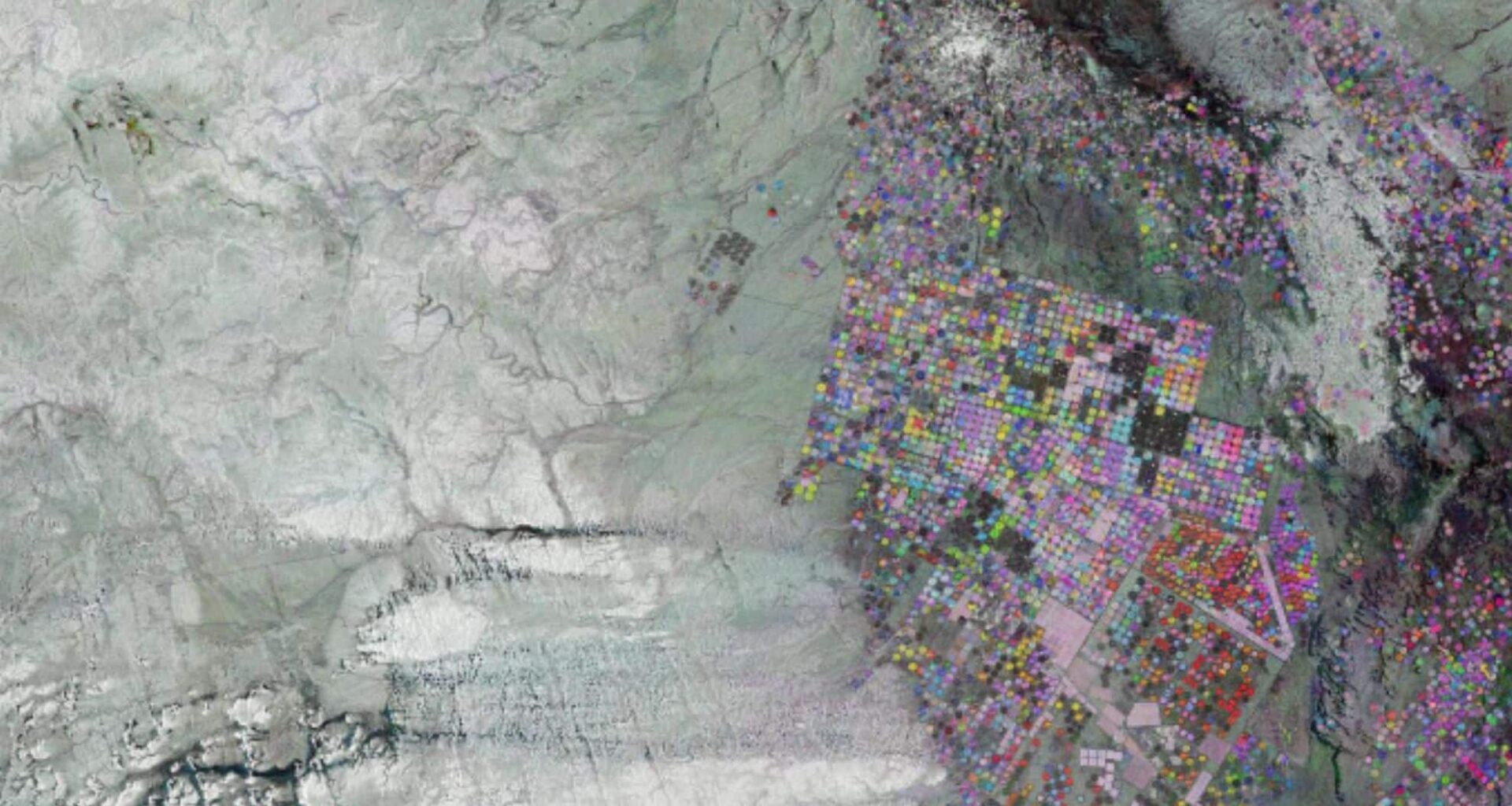
The Technology Behind the Image: Sentinel-1’s Role in Monitoring
What makes this image even more remarkable is the role of the Copernicus Sentinel-1 satellite in its creation. The ESA’s Sentinel-1 is part of a larger Earth observation program designed to monitor land use, environmental changes, and natural disasters. Over a period of seven months, the satellite captured radar images that were combined into a single composite image. Each of the three images—taken in October 2024, January 2025, and May 2025—was assigned a different color (blue, green, and red respectively) to highlight variations in land cover, crop growth, and irrigation practices.
The color-coded layering technique allows for a visual representation of how land is being utilized and the changes that occur over time. Blue, green, and red hues give insight into the different stages of crop growth, while areas appearing white, grey, or black reflect regions where little to no change has taken place. These could represent bare soil, fallow land, or desert terrain. This satellite data serves as a crucial tool for both local farmers and environmentalists, offering a way to track agricultural health, monitor water usage, and assess the environmental impact of human intervention in the desert ecosystem.
Agricultural Transformation in Saudi Arabia’s Desert Landscape
Saudi Arabia’s agriculture is heavily influenced by the country’s natural environment, characterized by its scorching temperatures and lack of freshwater resources. Despite these challenges, the northern regions, like the one depicted in the ESA’s image, have managed to turn vast stretches of desert into productive farmlands. The development of irrigation systems has been key to this transformation. In addition to central-pivot irrigation, the country also uses other methods like drip irrigation and the use of treated wastewater in certain areas.
The Wadi As Sirhan basin, shown in the image, is an example of how nature’s inherent features, such as valleys that fill with water during rare heavy rains, can be harnessed to support agricultural growth. This region, despite being located in a desert, is home to various crops thanks to sophisticated irrigation systems that reduce reliance on rainwater. The agricultural activity in the area not only supports local food production but also plays an essential role in providing sustenance to neighboring communities. This shift towards large-scale agriculture in a desert climate is slowly transforming the region’s economy, making it less dependent on oil and more diversified in terms of resources.
The Role of Tabarjal: A Hub for Northern Saudi Arabia
Nestled within the colorful circles is the town of Tabarjal, which is clearly visible in the top right of the image. This small town, despite its remote location in the desert, holds significant importance in northern Saudi Arabia. Thanks to its thriving agricultural sector, Tabarjal serves as a critical logistical and economic hub for surrounding rural communities. The crops produced in this area help support both the local and regional food supply, while the town itself is strategically positioned as a center for trade and services in this arid part of the country.
Tabarjal’s economic significance cannot be overstated. Its central location within the Wadi As Sirhan basin, coupled with its agricultural activity, makes it an essential part of the food production network that sustains northern Saudi Arabia. As the country continues to diversify its economy away from oil dependence, towns like Tabarjal are becoming increasingly important in the country’s agricultural landscape. The use of satellite imagery to monitor these changes offers valuable insights into how this transformation is occurring on the ground.