
Issued: 0530hrs Thursday 28th August 2025
Duty forecaster: Simon Keeling
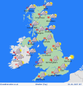 Heavy showers, starting in the west and then tracking east
Sunshine this morning in eastern areas, but low pressure is in control and this is bringing lots of showers in the west. The showers are heavy in places and will become increasingly thundery. There is a risk of some local flooding by late morning. The showers probably reaching all but the far northeast of Scotland and the far east of East Anglia by lunchtime.
This afternoon sees further, heavy showers and these become more widespread. Again a risk of thunder in places and some local downpours which could lead to some short-lived localised flooding. A coler afternoon and one with strong gusts of wind in the showers.
The showers should ease and fade for many this evening. However, there will be residual ones in the west, these turning heavier again after midnight as an area of showery rain also tracks through southern England.
Simon
Talk live to our forecasters for the latest forecast.
Call 0906 515 1506 (Calls charged at £1.55p/min from within the UK only, network charges may apply, service operated by WCS Ltd WV5 9JD, helpline 01902 895252)