
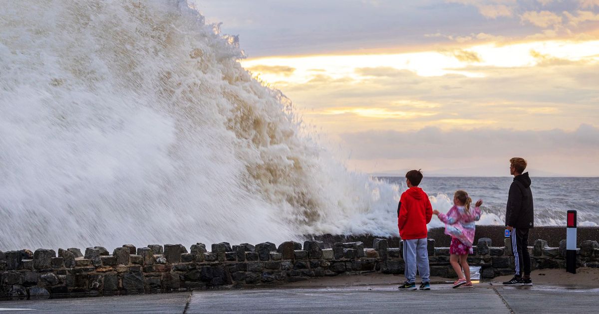
Properties and a section of promenade could be demolished. The process was scheduled to get underway in the next 30 years – but it’s hoped the plans can be delayed Onlookers at Barmouth promenade as giant waves crash against the resort’s seawall(Image: domvacher.com)
Future plans to sacrifice part of a Gwynedd resort are a stark reminder of the perils facing coastal communities as sea levels rise. Barmouth has been earmarked for potential “managed realignment” because engineers say its sea defences will become increasingly difficult to maintain.
It leaves the northern end of Barmouth facing the prospect of seafront loss coupled with the need to relocate residents and businesses. Engineering consultants Arup have warned of the need to need to tread softly and learn the lessons from Fairbourne, Barmouth’s neighbour.
It too once faced its own Doomsday scenario, its residents portrayed as Britain’s “first climate refugees” amid the prospect of complete abandonment. In an initial Barmouth analysis from 2019, Arup said: “A scheme which involves the loss or relocation of any properties is likely to be controversial or provoke strong local opinions, leading to significant risks to the future of a scheme and local community cohesion. “
Cyngor Gwynedd considers Managed Realignment (MR) to be currently “premature”. At one point the aim was to get the process underway in the next 30 years but it could now be delayed until 2075 and potentially even until the next century.
In the meantime, the council is advancing its north Barmouth coastal defence project. This near-future scheme involves repairing 1.2km of the promenade, raising the secondary wall, adding rock armour and landscape improvements.
The prom here is in bad shape, with “unsafe voiding” caused by sand depletion and wave action. In 2020 it was badly damaged during winter storms.
Without reinforcement, an estimated 757 properties could be at risk from flooding. The North Wales Live Whatsapp community for top stories and breaking news is live now – here’s how to sign up
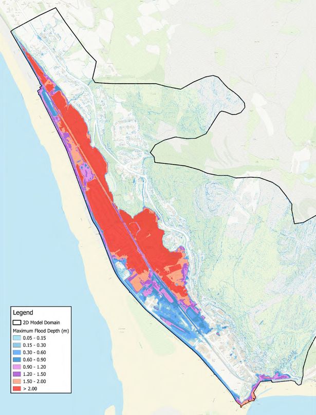 Barmouth’s potential flood cell in the absence of improvements currently proposed(Image: Cyngor Gwynedd)
Yet the prospect of MR, at some time in the future, continues to hang over the resort. One now-discounted idea would have involved the loss of the entire Hoel-y-Llan housing estate along with commercial properties and recreational facilities. Subsequent scheme refinements have since left two other MR options on the table – these are detailed below.
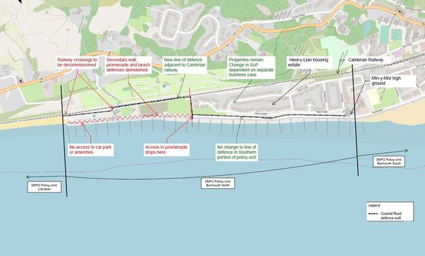
Even with lesser impacts, MR would be difficult to stomach. It would also be extremely expensive, potentially involving the demolition of a half-kilometre stretch of promenade and the construction of a new setback wall up to 280ft (85 metres) inland bordering the Cambrian Railway line. A road, cafe, car park and skate park could be decommissioned, with river outlets and below-ground assets diverted.
There are no legal precedents to guide Cyngor Gwynedd, and no strategy has been developed for the “widespread direct relocation of properties” in an area where land is in short supply.
Moreover, if a set-back wall is built, an initial line of defence will still be needed – to prevent the sea rushing in and overtopping the new inland defences, behind which are houses and a large caravan park.
As these lie on land lower than the current promenade, Arup said the absence of initial defences would “increase flood risk and risk to life to unacceptable levels” for people on the landward side of the railway.
 Reclaimed land beyond the north prom running up to the Cambrian Railway, with the Hoel-y-Llan housing estate in the distance(Image: Cyngor Gwynedd)Managed Realignment optionsOption 1
In this scenario, a new set-back wall for the railway would be built. The north promenade would be repaired and possibly raised so it can remain as an initial defence, enabling continued access by the public. Property loss would be minimised.
Repairs are not a forever solution: the threat will remain and, over time, the prom’s inevitable deterioration in the face of ever more violent storms could present an increasing “risk to life.
Flooding is also likely to become more common on the prom, café and Pen-y-Gogledd car park. “The increasing number of promenade closures would both increase operational costs and reduce revenues from car parking and other recreational activities,” said YCG, Cyngor Gwynedd’s engineering consultants.
Construction of new defences to protect the railway and prevent outflanking would involve a “significant upfront cost”. And as Cyngor Gwynedd does not own the undefended land, extra land costs may be incurred.
 Option 2 for Managed Re-alignment would see a half-mile section of the promenade demolished and a new set-back wall built along the Cambrian Railway(Image: Cyngor Gwynedd)Option 2
This is similar to option 1 with a new setback wall by the railway. But it’s even more costly as it involves demolishing part of the ageing promenade and building a new, smaller defence along a similar alignment. Unlike option 1, this will not provide public access.
This means the promenade café, car park and skate park will no longer be accessible. Two railway level crossings would also be closed off. “The only feasible option might be to abandon and decommission these assets,” said YCG.
“The entire area would be flooded considerably more regularly and would likely become permanently inundated to a large degree.”
Because of this, a larger, more complex setback wall is likely to be needed to reduce overtopping risk to the railway, and so avoid widespread flooding beyond.
Inundation by the sea would transform the abandoned area, especially if old reclaimed land is dug out. Quite how is still uncertain: a shingle ridge could develop, or perhaps a sandy beach similar to south Barmouth. “This may provide opportunities for ecological enhancement including sand dunes and coastal grazing marsh,” said YCG.
Hold the line
There is a third long-term option, one that’s mindful of present-day proposals to keep and repair the promenade. This would see the current “hold the line” strategy extended until 2075 at least, and possibly longer, eliminating the need for MR for the foreseeable future.
Promenade defences would need improving. Otherwise north Barmouth will, in time, flood regularly. Tidal locking could even occur – this is where raised sea levels stop rivers draining out to sea.
This will cause ongoing deterioration that will “increase the risk of collapse” in the medium to long-term. Although access to the promenade would be maintained in this scenario, it would need to close in flood events.
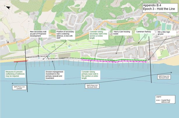 One idea is to continue Barmouth’s hold-the-line approach beyond 2075 with additional defences in front of the Hoel-y-Llan housing estate. However Managed Realignment appears more likely in the long-term (Image: Cyngor Gwynedd)
A more realist hold-the-line option is to bulk up the promenade even more. This could include increasing its height, adding more rock revetment and constructing a new wave modulation structure offshore.
Such improvements would need to be assessed as a separate business case to the near-future project that’s currently being considered. Yet it’s the option now preferred by Cyngor Gwynedd and its engineers. Partly this is because MR costs are so high. But there’s also concern that MR could put critical infrastructure, such as the Cambrian Railway, at even greater risk.
The problem
A stumbling block for hold-the-line ambitions is the Shoreline Management Plan 2 (SMP2), which sets out the Welsh Government’s overall strategy for managing coastal flood and erosion risk for west Wales.
This advocates hold-the-line policies both for south Barmouth and Llanaber slightly further north. These two areas bracket north Barmouth and SMP2 acknowledges their coastal processes are all interlinked. As such, SMP2 prefers their coastal defence policies to be “progressed as one overall area”, with integrated shoreline management.
To achieve this may require a “nearshore or shore-connected structures to reduce wave energy”, it said. Even so, SMP2 predicts the hold-the-line approach will become “increasingly difficult to sustain” at north Barmouth and expects MR will be needed before 2055.
For this reason, the council intends to challenge this policy in the hope it can maintain and upgrade the north prom defences “in the medium term”, taking its lifespan to 2075 and perhaps even up to 2125. A policy change subgroup has been set up by the West Wales Coastal Group to discuss the council’s preferences with the National Coastal Forum.
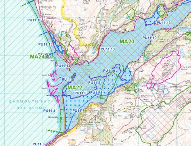 In the West Wales Shoreline Management Plan (SMP) 2, the entire coastline was divided into Policy Units (PU). Barmouth’s frontage has two units (PU14-15) and these are considered together with PU16, which covers Llanaber (top left)(Image: Cyngor Gwynedd)
Already, designs for defences with a 100-year-plus lifespan have been mooted – though so too has a structure with a shorter shelf-life, to avoid the need to decommission assets in the 2070s that still have residual value.
Prom longevity will depend on a myriad of factors, not least funding, climate factors, prom resilience and ongoing coastal processes. For this reason, project dates are not set in stone: evolving climate science and sea level data may force a rethink. However the SMP2’s stance is a hurdle for Cyngor Gwynedd’s ambitions to extend the life of Barmouth’s promenade.
What next
In its outline business case (OBC) for north Barmouth’s near-future coastal defences, Cyngor Gwynedd’s preferred approach is to implement MR “in the long-term epoch” (between 2075-2125). If it can get the SMP2 changed to allow this, it would enable the full length of north prom to be retained for longer, giving residents the chance to enjoy tourism, social and amenity benefits potentially for many more decades.
The council said: “The preferred approach is an adaptive pathway that involves investing now in actions to manage today’s risks, monitoring the change in risk over time – such as the impact of climate change and response of coastal processes across the three frontages – and a plan to manage these changes.”
In the meantime, the plan is to keep a watching brief: post-2075 concepts have yet to be developed. MR strategies will be further refined in the expectation they will be needed at some point.
The approach contrasts sharply with that taken at Fairbourne across the Mawddach estuary. In 2014, Cyngor Gwynedd said it could not maintain the village’s flood defences indefinitely as global sea levels rose, with Natural Resources Wales identifying 2054 as the potential tipping point.
Faced with the prospect of total abandonment, the community rallied, queried the data and offered its own solutions. Since then the official message has become less definitive, prompting hope that mitigations can be found to manage future flood risks in the village.
In north Barmouth, it seems Arup’s tread-softly advice is being heeded. Get all the latest Gwynedd news by signing up to our newsletter – sent every Tuesday
Another round of community consultation is running until November 21 – views can be emailed to callabermaw@gwynedd.llyw.cymru. The plans can be found here.
Find out what’s happening near you