
Weather maps suggest two snow systems could hit the UK on February 13 and 15, with the Scottish Highlands potentially seeing up to 14 inches and the North East also hit
Ethan Blackshaw Social News Content Editor
20:29, 31 Jan 2026
Heavy flurries will continue throughout the day, maps suggest(Image: WX CHARTS)
Two severe snowstorms are forecast to blanket much of Britain in snow, with weather charts indicating certain areas could experience accumulations of up to 14 inches.
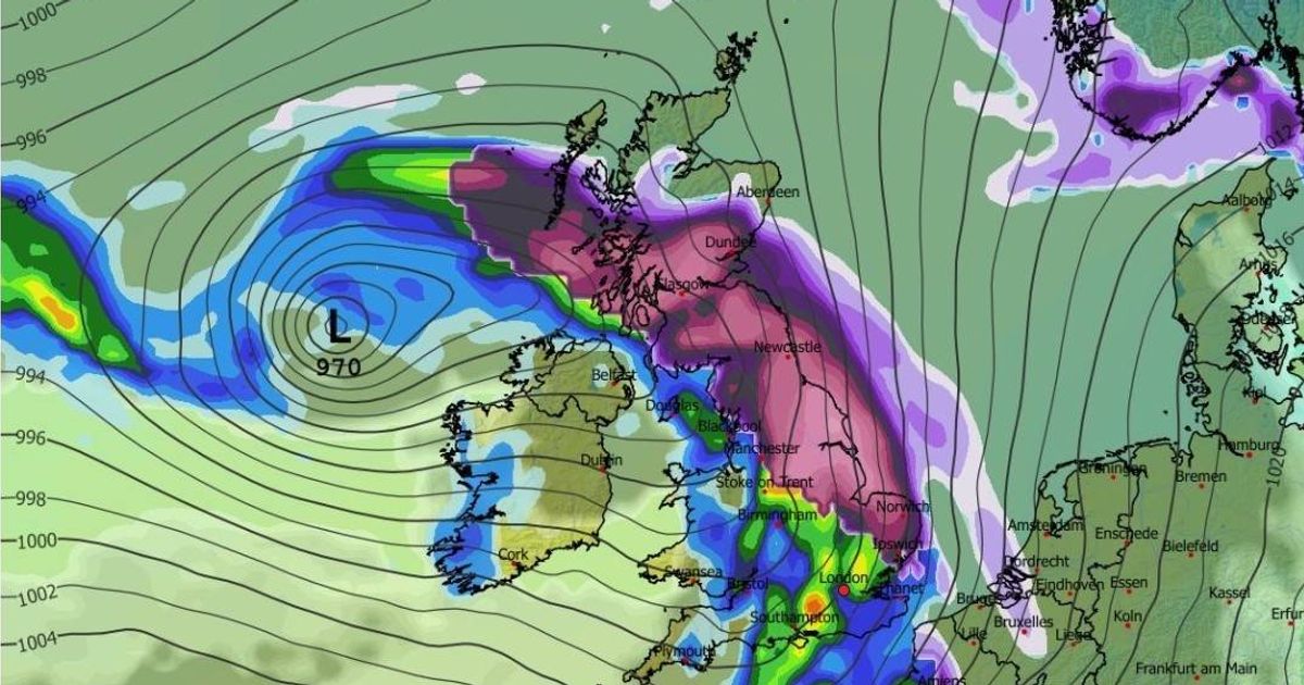
The GFS weather model initially depicts snow traversing the UK during the morning hours of February 13, with precipitation sweeping across Northern Ireland, Wales, central and northern England, alongside Scotland.
Metropolitan areas such as Birmingham, Manchester, Liverpool, Belfast, Edinburgh and Glasgow may all find themselves in the path of the storm. Snowfall could potentially extend as far south as the capital.
Come midday on February 13, the meteorological charts indicate the heaviest snowfall will be concentrated in eastern and northern territories. East Anglia and Yorkshire appear poised to bear the brunt, whilst Scotland faces additional flurries during this period.
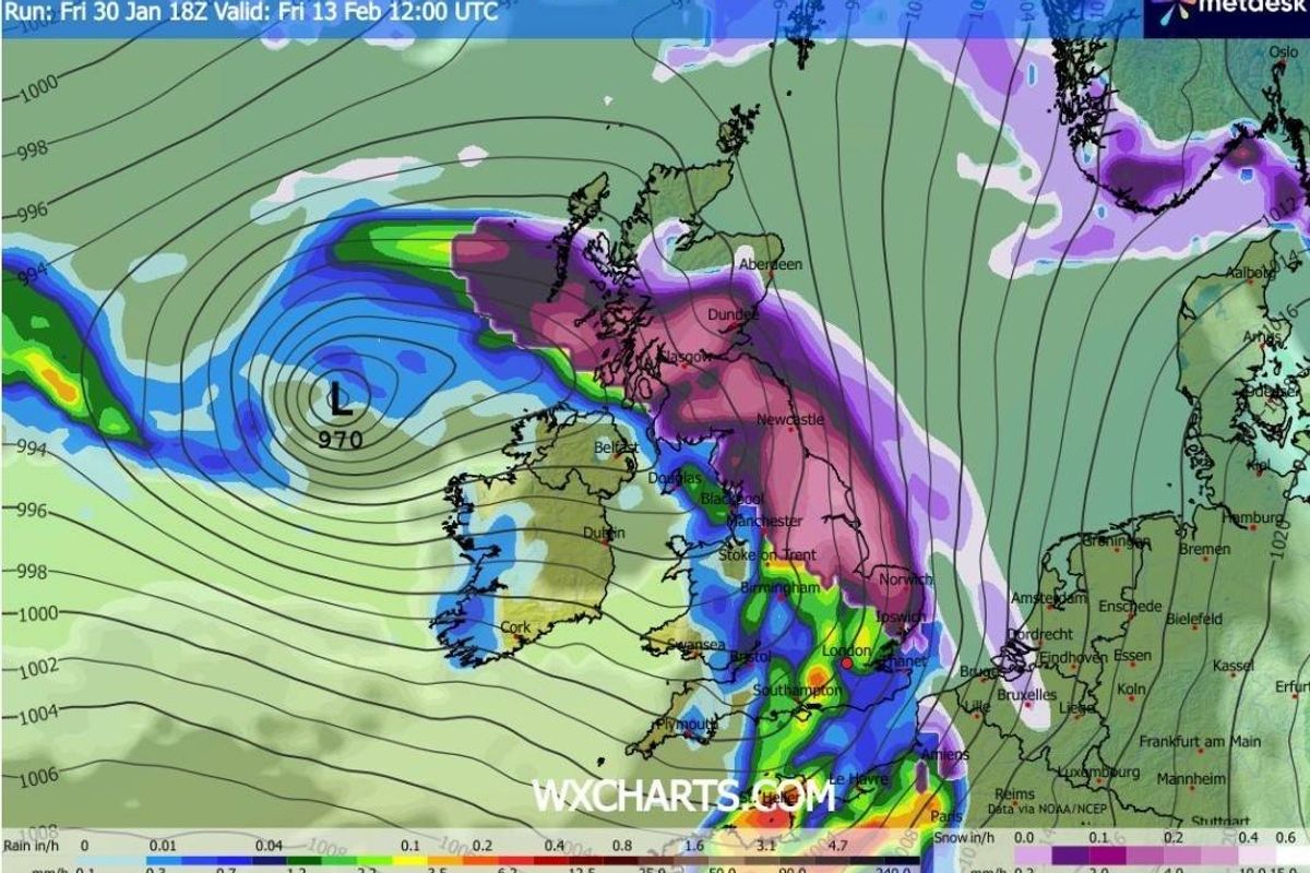
The subsequent blizzard is projected to strike Britain on February 15, with Northern Ireland initially confronting the most substantial snowfall. The Midlands and north-west England may also encounter snow during the early morning hours, reports the Mirror.
Around 3am, the GFS model depicts heavy flurries extending from East Anglia, through central and northern England, reaching as far as Northern Ireland. The snow is expected to progress northwards, the charts suggest, enveloping Scotland by 6am as well.
Heavy flurries will continue throughout the day, maps suggest(Image: WX CHARTS)
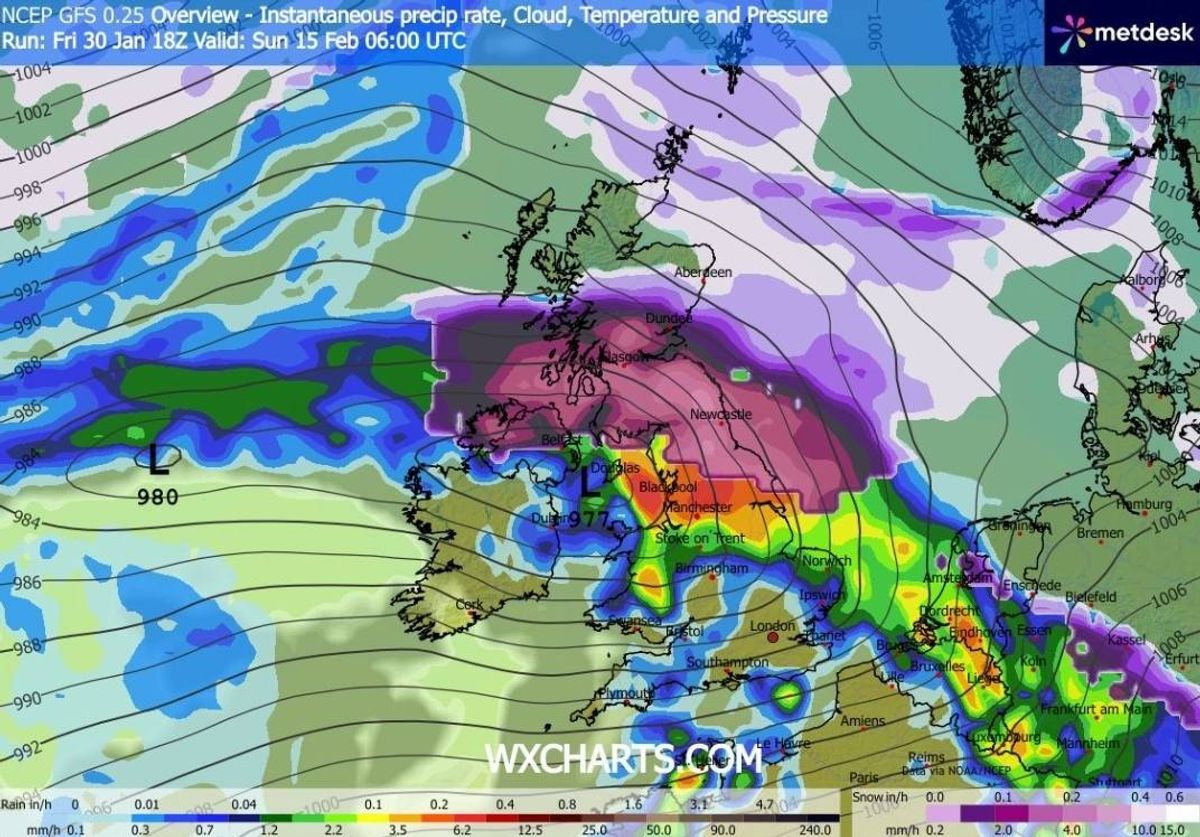
Snow coverage charts reveal the comprehensive scope of this wintry weather event, with the vast majority of Britain and Northern Ireland anticipated to witness some settled snow on the ground. The data indicates that by 3pm on February 13, only southern portions of England will remain snow-free.
Charts indicating snow accumulation suggest up to 36cm (14 inches) may blanket the Scottish Highlands, whilst areas across northern England might experience as much as 11cm (four inches).
The Met Office has indicated that wintry conditions could arrive next month. Their outlook covering February 4 to 13 explains: “Frontal systems over the North Atlantic, steered by a south-shifted jet stream, are likely to approach the UK at times, but tending to stall as they encounter a blocking area of high pressure to the north and northeast.
“This will result in further spells of rain at times, falling in areas already sensitive to flooding. As these bands of rain spread northwards, some snow will be possible on high ground in northern England and Scotland as they encounter colder air.
“A subtle shift southwards of these areas of low pressure is anticipated during the second week of February, which may allow a greater chance of colder air to spread across northern UK at least, bringing an increased risk of wintry hazards for a time.”
That said, BBC Weather indicates that extensive snowfall appears unlikely. Their projection spanning February 9 to 15 notes: “A colder set-up is expected to develop during the second week of February, as a stronger push of high pressure comes in from the north and north-west towards the UK. This will provide more resistance to fronts and milder air trying to edge northwards, and colder air should win out, with temperatures dropping below average right across the UK.
“Even southern England could see temperatures at least slightly below seasonal values. These low temperatures will be exacerbated by brisk easterly winds at times, so areas towards eastern coasts may feel particularly cold.
“Changeable conditions are expected. It should become somewhat drier overall, especially later in the week, but occasional showery outbreaks are still likely. These will turn wintry over higher ground, and down to lower levels in some northern regions.
“However, at the moment there is no sign of any major snow event. Drier and calmer interludes will lead to sharp overnight frosts and risks of fog.”
Our ChronicleLive Daily newsletter is free. You can sign up to receive it here. It will keep you up to date with all the latest breaking news and top stories from the North East.
 Join our WhatsApp communities
ChronicleLive is now on WhatsApp and we want you to join our communities.
We have a number of communities to join, so you can choose which one you want to be part of and we’ll send you the latest news direct to your phone. You could even join them all!
To join you need to have WhatsApp on your device. All you need to do is choose which community you want to join, click on the link and press ‘join community’.
No one will be able to see who is signed up and no one can send messages except the ChronicleLive team.
We also treat our community members to special offers, promotions, and adverts from us and our partners.
If you don’t like our community, you can check out any time you like. To leave our community click on the name at the top of your screen and choose ‘exit group’.
If you’re curious, you can read our privacy notice.
Join the ChronicleLive Breaking News and Top Stories community
Join our Court & Crime community
Join the Things to do in Newcastle and the North East community
Join our Northumberland community
Join our County Durham community
Join our Great North Run community