
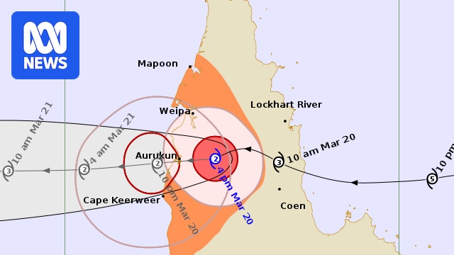
Tropical Cyclone Narelle is impacting the western coast of Cape York, including the community of Aurukun, as a category two system.
The Bureau of Meteorology (BOM) warns destructive wind gusts up to 150 kilometres per hour are likely near its centre as it moves toward the coast.
On Friday evening, it was about 50 kilometres east of Aurukun, travelling west at 18km/h.
Tropical Cyclone Narelle made landfall near Coen on the eastern side of the Cape on Friday morning as a category four system with wind gusts of more than 250km/h.
Authorities warn a danger remains for communities due to high winds and heavy rainfall, with estimates that it could dump up to half a metre of rain in some areas.
Cyclone Narelle live: For the latest news on the cyclone, read our blog.
Danger from wind, rain, flooding
As the severe system crossed the coast, some residents hunkered down in bunkers and boats as the “freight train” passed.
Premier David Crisafulli said there were four major risks as the cyclone moved over the state.
“Wind, storm surge, rain, and then the prospect of flooding,” he said.
“Wind is intensifying. In many cases, it will be the strongest wind that people have experienced in this part of the state for a long, long time.”
Mr Crisafulli said towns were now facing “a significant loss of power” and rains were already creating new risks along waterways.
“The river at Archer River Bridge has gone from 5 metres to 13 metres, so it’s getting close to what is a new elevated bridge.
“That gives you an indication of the amount of water in this system.”
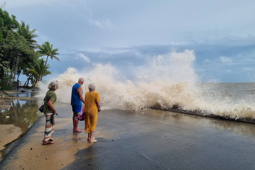
The impact of Tropical Cyclone Narelle has been felt more than 500 kilometres south, with waves surging at Trinity Beach in the Cairns region. (Supplied: Shelley Sparrow)
Half a metre of rain could fall
Wenlock River has recorded more than 300mm in the past 24 hours, and more than 120mm since 9am.
Matthew Collopy from the Bureau of Meteorology (BOM) said large parts of the far north would continue to be soaked by the cyclone as it headed west over the next 24 to 48 hours.
“We are expecting totals in excess of 200mm from Ingham right the way up the coast to the Lockhart River and across the cape,” he said.
“Those totals will increase to an excess of 500mm for areas north of about Cooktown, and as I mentioned, a very real possibility of flash flooding.”
Take Shelter Now emergency warnings have been issued for many communities, including Hope Vale, Lockhart River, Cook Shire, Coen, Port Stewart, Portland Roads, Aurukun, Weipa and Wujal Wujal.
Wind direction and intensity of Tropical Cyclone Narelle. (Supplied: Nullschool; MIT Licence)
The cyclone warning zone in Queensland is for Western Cape York Peninsula between Mapoon and Pormpuraaw, including Weipa, Aurukun, and adjacent inland areas.
In the Northern Territory, it is in place for Nhulunbuy to Port McArthur, including Borroloola, Numbulwar, Alyangula, and Gapuwiyak.
A watch zone is in place for the Northern Territory extending to Ramingining, Bulman, and Ngukurr.
Cyclone warnings for the east coast of the Cape, including Lockhart River and Coen, have been cancelled.
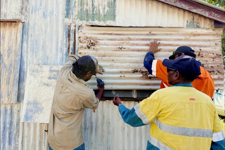
Locals in Coen spent the week preparing houses and buildings for the direct impact of Severe Tropical Cyclone Narelle. (Supplied: Dion Creek)
Towns eye-to-eye with Narelle
A guide to the townships directly in the path of Tropical Cyclone Narelle as it passes over Queensland on Friday morning.
Coen:
Population of just under 300Busy in dry season with tourists heading to tip of Cape YorkKey supply point to Weipa and other northern communities
Aurukun:
Population of about 1,200Town has 182 community houses and 16 staff housesAverage rainfall of 1.77 metres with roads often cut off through the wet seasonThe community is also young in age, with a higher number of people under 25 compared to the rest of the state, and very few over 65
Weipa:
Population of just over 4,000The existing town was largely built by Rio Tinto, formerly Comalco, and still has one of the largest bauxite mines in the worldAlso a well known spot for anglers
Pormpuraaw:
Population of about 600The community relies on electricity supplied by a generator and water from a bore that is pumped into tanksTwo shops in the town, with fresh fruit, vegetables and milk weekly by truck or plane’We have lost a few roofs’
Debbie Jackson lives 50km north of Coen.
She said the rain had been falling all night, and all seven people on the property would be staying in a shipping container on the property.
“Lots of trees down. We have lost a few roofs. It’s not real great,” she said.
“We just have to ride it out.”
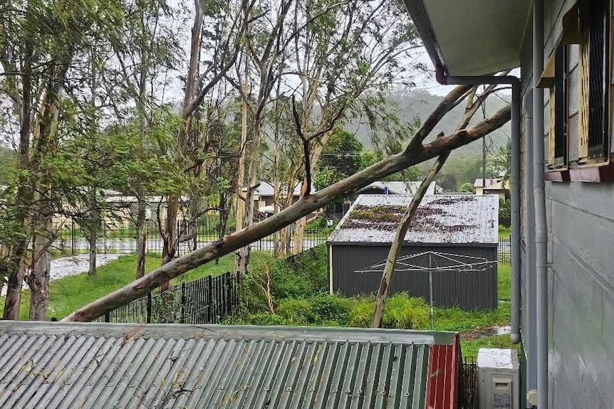
Tropical Cyclone Narelle has brought down trees in towns such as Coen. (Supplied: Josh Lennon)
‘An emotional rollercoaster’
Lucretia Huen’s husband and nine-year-old daughter were among those sheltering at the Wellbeing Centre in another part of town.
Ms Huen is away for work, so is being updated on their situation from afar.

Lucretia Huen’s daughter reads a book as Tropical Cyclone Narelle looms over Coen on Friday morning. (Supplied: Lucretia Huen)
She said it was an emotional rollercoaster to not be with her family.
“They have heard branches start to fall on the roof but no real damage yet,” she said.
Ms Huen said the Wellbeing Centre was not cyclone-rated but was the only option for the community.
The weather bureau expects the tropical cyclone will head towards Aurukun, weakening to a category two system through the afternoon before entering the Gulf of Carpentaria late in the evening.