
As the largest cyclone in a generation steamed towards her remote cattle station, Debbie Jackson, her husband, Kevin, their family, and a family friend took cover the best they could, in shipping containers. The seven stayed up all night in anticipation of the arrival of Tropical Cyclone Narelle.
Boasting wind gusts up to 270km/h, the storm tore through Archer River, a tiny community about 650km north of Cairns, the most northerly city in Queensland, Australia. Witnesses say the winds tore trees from the ground, dumping them on to houses and sheds.
But the Jacksons’ neighbour Debbie Cameron was equally concerned about rising flood waters spreading from the Archer River.
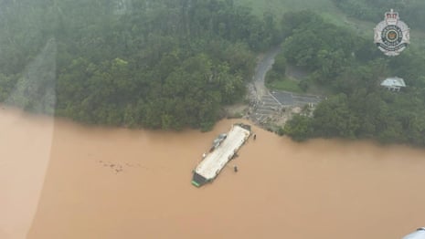 Aerial footage shows flooding in far north Queensland from Tropical Cyclone Narelle – video
She anticipated that her refuge, the Archer River roadhouse she manages, would flood. Cameron made a plan to escape to a nearby hill to take cover under a vehicle when the waters did rise, but even that was a race between the water rising and the wind dropping.
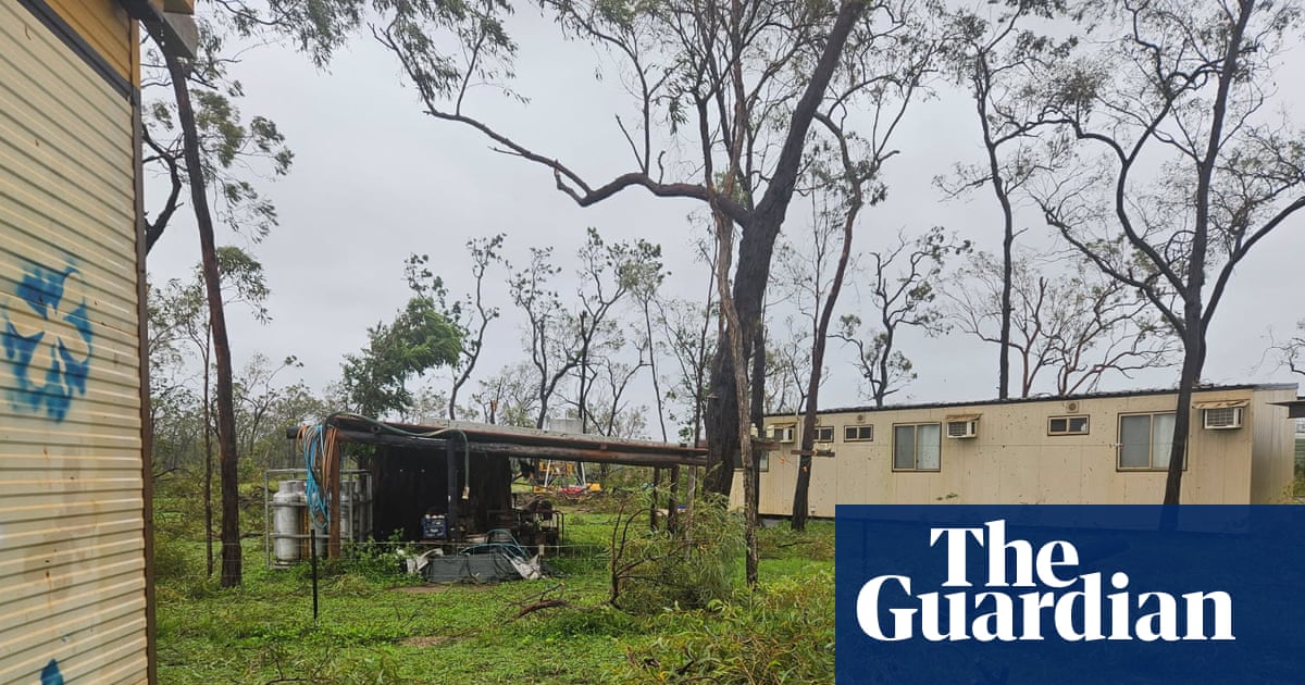
“She’s devastation here,” Cameron says. “We’ve got buildings crushed, sheds down.
“I don’t think there’s a leaf left on any tree.”
Tropical Cyclone Narelle made landfall in remote Cape York on Friday morning, only two days after forming in the Coral Sea. The storm travelled as fast as 25km/h, according to a forecaster from the Bureau of Meteorology.
Record ocean temperatures fed the storm, which quickly increased in intensity to the highest possible category 5 offshore. It was forecast to cross the coast at that level.
Sign up for the Breaking News Australia email
Nestled along the coastline, a three-hour drive north-east of Coen, the 700-strong Aboriginal community of Lockhart River sustained substantial damage after Cyclone Narelle landed there at about 9am on Friday morning.
Throughout the day, powerlines tumbled, large trees were ripped out of the ground and landed on homes, and debris floated around. The local airstrip will require repairs before another plane can land there.
However, David Clarke, the CEO of the shire council, says the community was left “relatively unscathed” as they had prepared for two days for the arrival of the category 4 system.
“All of our folks are cyclone-hardened from birth, so they understand,” Clarke says.
“Our preparation was pretty good. Our community is a very resilient one.”
‘Anything that comes up at 315km/h is going to make people nervous, including me’ … storm damage in Coen. Photograph: Queensland police
Clarke says he has been living in the community since the 1980s and has experienced multiple cyclones. In a strange coincidence, the seventh anniversary of the last one, Tropical Cyclone Trevor, fell on Thursday.
“Unlike Trevor, where we had all sorts of seabirds falling out of the sky before the system hit us,” Narelle was not as bad as predicted, he says.
“It was very windy, obviously. Probably 130 to 140km/h winds. It didn’t get to the 160km/h that the BoM was predicting, but no one is whingeing about that,” Clarke says.
“It was bloody horrendous, but we didn’t have it as bad as Trevor this time.
“[But] Anything that comes up at 315km/h is going to make people nervous, including me.”
How Tropical Cyclone Narelle was tracking on Friday evening. Photograph: Bureau of Meteorology
The Queensland premier, David Crisafulli, spent three days urging residents of the remote area, many of them experienced cyclone survivors, to take the storm seriously.
“If a category 5 system crosses the coast in this location, it’s the first time that’s happened in over 100 years,” he said.
The weather system produced sustained winds of 195km/h, only 5km/h shy of the highest possible category, a level 5 cyclone.
The storm had been expected to hit the small town of Coen with a population of 320. Some residents had left the town, and parts of north Queensland were evacuated. But as it made landfall, it swung north, away from Coen. It did not go so far as to hit Lockhart River; Crisafulli said it had “threaded the needle between both”.
As of Friday afternoon, there were no reports of injuries, he said. The last big cyclone to hit the area, Tropical Cyclone Mahina in 1899, cost 307 lives.
“Whilst there is some damage that we’ve seen … that is an incredibly good news story,” Crisafulli said.
‘We got really lucky that we were just slightly south of it’ … screenshot of police vision from far north Queensland. Photograph: Queensland police
Coen resident Koi Ngoreoge spent the evening in her bathroom. She shifted a mattress and cooking equipment in there, as it was the most secure room in the house.
By the time she woke up in the morning, it was already hitting, she says.
“I’m making breakfast in the bathroom,” she jokes.
Sarah Watkins from Coen says: “We got off lightly.”
She took shelter at the local pub, the Exchange Hotel, because it is made of brick. But she returned home mid-Friday morning, after the wind dropped off.
The whole town banded together to make sure everyone was safe, fed and watered, she says. They were expecting massive damage, so she says there was a sense of relief it had not been much worse.
Locals outside the pub in Coen after Tropical Cyclone Narelle swept through. Photograph: Sara Watkins
“It was a direct hit forecast. We got really lucky that we were just slightly south of it, so the damage hasn’t been too bad,” she says.
Only parts of the town lost power, not including her area, but the river was rising and the town was cut off.
Narelle had dropped strength to category 3 and was expected to weaken further to category 2 before it crossed the central Cape York Peninsula.
It was forecast to move west into the Gulf of Carpentaria on Friday night and strengthen once again before a second landfall expected late on Saturday night or early Sunday near in the Northern Territory.