
Science & Exploration
06/08/2025
1355 views
42 likes
In its latest postcard from Mars, the European Space Agency’s Mars Express returns to Acheron Fossae: a dramatic network of chasms carved into the surface of the Red Planet.
Context map of Acheron Fossae on Mars
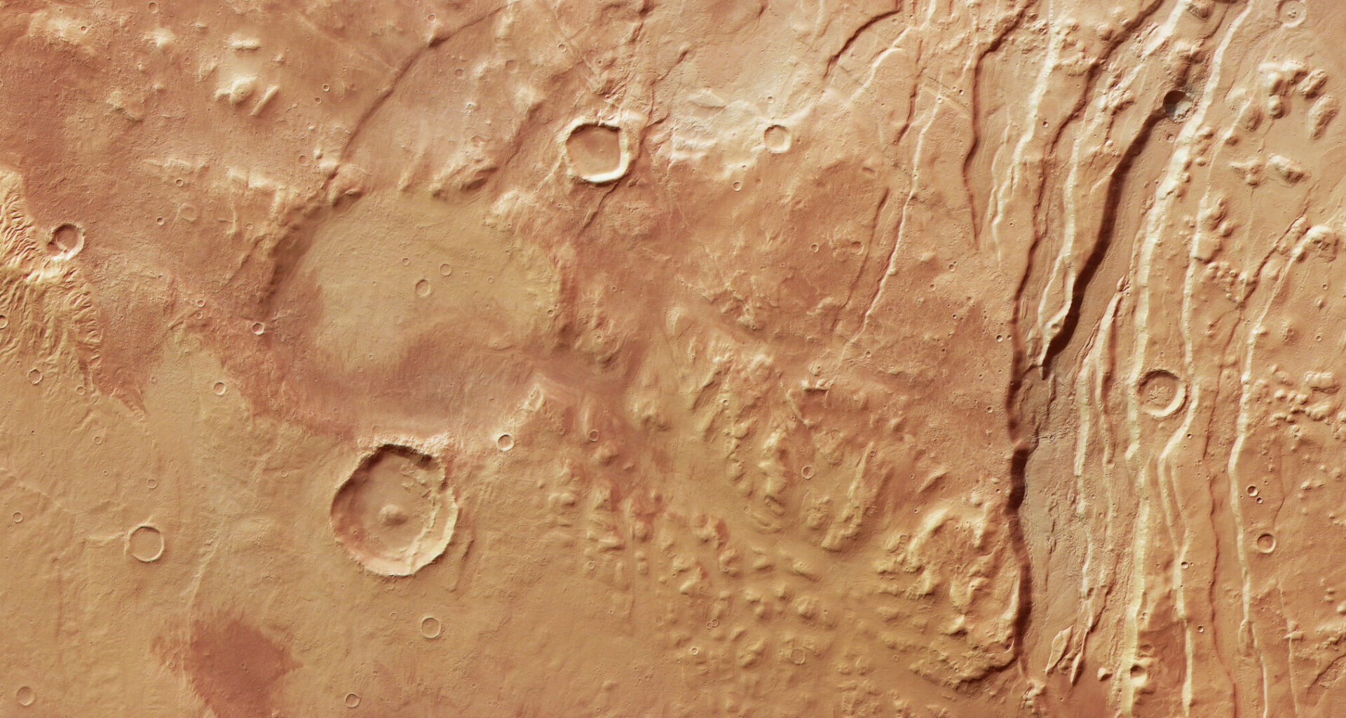
In April, we highlighted the eastern end of the Acheron Fossae region of Mars – an amazingly diverse mix of rugged and smooth terrain covered in ancient ditches, craters, and solidified lava – as seen by Mars Express’s High Resolution Stereo Camera (HRSC). Today we head back to show the region’s western edge, where the features are equally diverse: deep cracks, valleys, and meandering channels sculpted and filled by slow-moving flows of ice and rock.
Demonstrating just how intriguing these features are, one of the earliest image releases from HRSC also explored Acheron Fossae, all the way back in April 2004 – just months after Mars Express began investigating the Red Planet.
Broken ground
Acheron Fossae is an extensive system of deep, fault-like cracks (known as fossae), with alternating chunks of raised and lowered ground (a ‘horst and graben’ pattern, with ‘horst’ referring to a raised block of ground formed in this way, and ‘graben’ a lowered one). This pattern can be seen most clearly in the prominent channels slicing vertically through the frame just right of centre.
Likely dating back over 3.7 billion years to when Mars was most geologically active, such a pattern was created as hot material rose upwards beneath the martian crust. This upwelling of molten rock stretched and pulled the surface apart, creating kilometre-deep cracks and valleys – some of which are many hundreds of kilometres long.
What lies beneath
A bird’s-eye view: See Acheron Fossae from above
Once created, these valleys continue to transform. As shown clearly in the generated bird’s-eye view, the valley floors are relatively smooth, marked by gently weaving lines reminiscent of a flowing river. Rather than water, these valleys have been filled by a slow, viscous flow of ice-rich rock, a lot like the rock glaciers we see here on Earth.
Rock glaciers are very sensitive to changes in climate, and so act as good markers for how a planet’s environment has changed over time. Here, they indicate that this region of Mars has experienced alternating periods of cool and warm, freeze and thaw.
These temperature fluctuations are driven by the tilt of Mars’s rotational axis; unlike Earth, which sticks at a reasonably steady and moderate tilt due to the stabilising influence of our large Moon, Mars’s tilt varies dramatically over time. This leads to alternating warm spells and ice ages, periodically letting ice creep near to the planet’s equator before shrinking back to its poles.
While Earth and Mars both experience tilt fluctuations in this way, the variations are far bigger on Mars. Mars’s tilt has swung between 15 and 45 degrees in the last 10 million years, while Earth’s has varied between 22 and 24.5 degrees. These regular shifts – known as Milankovitch cycles – play an important role in our planet’s climate, but their effects are more subtle than those on Mars.
Left behind
To the right of frame the fossae transition into flat, dark lowland plains, with a knobbly strip of raised mounds and rocky hills in between. These are the remains of what was once a continuous rock layer; over time, flows of ice and rock have worn away the ground here, leaving behind rounded hills (knobs) and flat-topped plateaus (mesas) interspersed with narrow, meandering channels.
This transition – from fossae through knobs and mesas to lowland plain – is seen especially clearly in the associated topographical image of this region, where red and yellow tones (indicating higher ground) melt into light and darker blues (indicating lower elevations).
Topography of Acheron Fossae’s western edge
Another patch of smooth ground can be seen to the left. This plain lies next to the largest volcano in the Solar System, Olympus Mons, which lies around 1200 km out of frame to the south (left).
ESA’s Mars explorer
Mars Express has been capturing and exploring Mars’s many landscapes since it launched in 2003. The orbiter has mapped the planet’s surface at unprecedented resolution, in colour, and in three dimensions for over two decades now, returning insights that have drastically changed our understanding of our planetary neighbour (read more about Mars Express and its findings here).
Acheron Fossae’s western fringes in 3D
The Mars Express High Resolution Stereo Camera (HRSC) was developed and is operated by the German Aerospace Center (Deutsches Zentrum für Luft- und Raumfahrt; DLR). The systematic processing of the camera data took place at the DLR Institute of Planetary Research in Berlin-Adlershof. The working group of Planetary Science and Remote Sensing at Freie Universität Berlin used the data to create the image products shown here.
Like