

Your support helps us to tell the story
From reproductive rights to climate change to Big Tech, The Independent is on the ground when the story is developing. Whether it’s investigating the financials of Elon Musk’s pro-Trump PAC or producing our latest documentary, ‘The A Word’, which shines a light on the American women fighting for reproductive rights, we know how important it is to parse out the facts from the messaging.
At such a critical moment in US history, we need reporters on the ground. Your donation allows us to keep sending journalists to speak to both sides of the story.
The Independent is trusted by Americans across the entire political spectrum. And unlike many other quality news outlets, we choose not to lock Americans out of our reporting and analysis with paywalls. We believe quality journalism should be available to everyone, paid for by those who can afford it.
Your support makes all the difference.Read more
Temperatures are set to soar to highs of 29C this weekend as a week of rain and cloud makes way for sunshine.
Showery spells and unsettled conditions are expected to dominate the week, with a chance of hail and thunder in places.
But forecasters say a spell of “above average” temperatures and bright conditions is on the way from Saturday and into next week.
The Met Office predicts below-average temperatures throughout the week as it warned of chilly and wet weather.
Stormy conditions are expected on Tuesday across the north of England, where forecasters said hail and thunder are possible.
This is set to culminate in a deluge of rain forecast to blanket the UK on Thursday, before moving eastwards.
But the outlook is expected to turn brighter from Friday, with temperatures climbing to the early twenties in the southeast of England as pressure builds across the country.
 Temperatures are expected to soar over the weekend (PA Wire)
From Saturday, temperatures are expected to soar to as high as 29C, with potential for even higher in some places.
Deputy chief meteorologist Steven Keates said: “From this weekend the UK forecast will have a distinctly warmer and drier component with a prolonged spell of above-average temperatures, with values in some locations quite likely to reach 27 to 29C, with the potential for higher values than this.”
High pressure is expected to remain close by to the UK until Tuesday, bringing widely settled conditions and often above-average temperatures.
Forecasters said settled conditions are “likely” to continue into next week, but warned temperatures may not remain as warm.
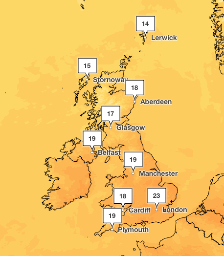 Temperatures are expected to climb from Friday (Met Office)
Full forecast for this week
Monday
A wet start across England and Wales as a band of rain, heavy at times, moves southeastwards. Sunshine and showers across Northern Ireland and Scotland, with this spreading to most areas by the end of the day. Cool and breezy.
Monday night
Mostly dry in the evening across England and Wales, but frequent showers for Northern Ireland and Scotland. These spreading to most areas overnight. Turning rather chilly under the clearest skies.
Tuesday
Sunny spells and showers. Showers most frequent in the North, where they could be heavy and thundery at times. A cool-feeling day for the time of year.
Outlook for Wednesday to Friday
Sunshine and showers Wednesday. Rain pushing eastwards Thursday, followed by sunshine and showers Friday. Staying on the cool side, though turning a little warmer in the far South East come Friday.