
A few lingering showers are present Saturday morning in the Foothills and Sierra with more scattered showers expected to arrive this afternoon. Today is the day to prepare for a very active week… clean out drains, rake and bag leaves, and secure loose outdoor decorations. Sunday and Monday are KCRA 3 weather Impact Days. Wet and breezy conditions are expected each of those days for the Valley and Foothills. The Sierra will see mainly rain through Tuesday.Wednesday and Thursday are now weather Alert Days. A strong storm with heavy rain, high winds and heavy snow will significantly impact plans for Christmas Eve and Christmas Day. Rain and snow will continue Friday at a lighter intensity.Rainfall:Atmospheric river moisture will be a major ingredient in next week’s weather setup. That means rain will be persistent and sometimes heavy, especially in the hills.Rain totals will be highest in the Sierra and upper Foothills. Places like Blue Canyon could see up to 20 inches of rain from Saturday night through Wednesday.Placerville, Nevada City, Sonora and other communities in the Foothills could close to 12 inches of rain. The Coastal Hills in Lake County could see 8 to 10 inches of rain.The Sacramento and San Joaquin Valley could see up to 6 inches of rain through Thursday.Flood Watch:A Flood Watch will be in effect from Saturday afternoon through Friday afternoon for all of Northern California, but potential flooding impacts will vary throughout the week.Street flooding is what’s most likely, but that will be isolated to areas that don’t drain well. Remember, if you do come up to a flooded road, do not try to walk, ride or drive through it.Northern California’s river basins and reservoirs have plenty of room to take in runoff as rain begins. Creeks will rise Sunday and Monday, but flooding is not expected through Tuesday.Creek flooding is more likely Wednesday through Friday in the Valley and rounds of heavier rain tack on to the impressive totals we’ll see earlier in the week.Rivers that are controlled by dams and reservoirs will not flood. This includes the lower American River, the Yuba River, the Feather River and the Sacramento River.Minor flooding on the Cosumnes River is possible towards the end of next week, but it’s unlikely to reach the level we saw several years ago around New Years Day.Residents in Modesto should also keep an eye on the Tuolumne River. Water levels will rise at the end of next week.Snowfall:Snow is badly needed in the Sierra, and it’s finally in the forecast. The summits could see feet of powder later next week.Snow levels Saturday, Sunday and Monday will mainly stay above the passes. The exception could be during the overnight hours when temperatures could be just cold enough for snow at the summits.Tuesday is when the snow level may drop enough for snow to fall at the summits, but precipitation will likely be light on Tuesday as the best moisture shifts north.Travel delays, chain controls and possibly even closures are more likely Wednesday, Thursday and Friday of next week. These are days to avoid mountain travel if possible.
SACRAMENTO, Calif. —
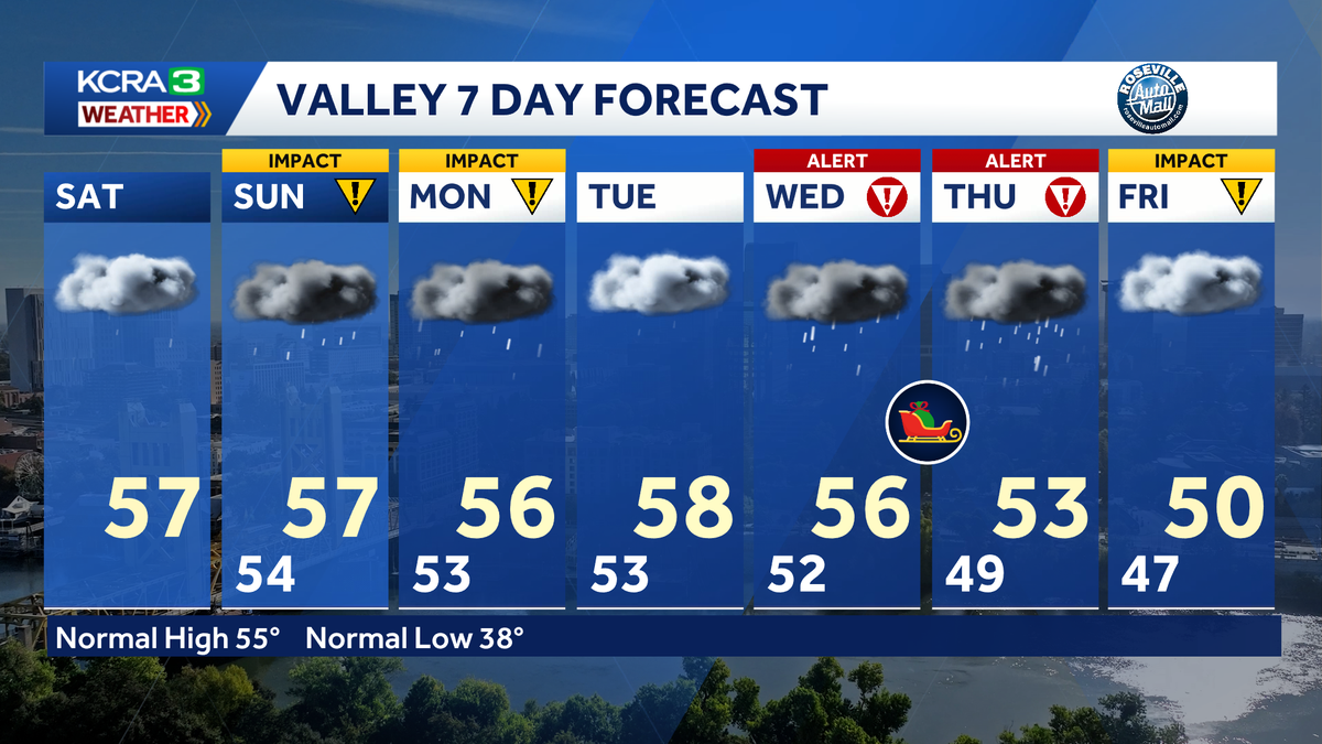
A few lingering showers are present Saturday morning in the Foothills and Sierra with more scattered showers expected to arrive this afternoon. Today is the day to prepare for a very active week… clean out drains, rake and bag leaves, and secure loose outdoor decorations.
Sunday and Monday are KCRA 3 weather Impact Days. Wet and breezy conditions are expected each of those days for the Valley and Foothills. The Sierra will see mainly rain through Tuesday.
Wednesday and Thursday are now weather Alert Days. A strong storm with heavy rain, high winds and heavy snow will significantly impact plans for Christmas Eve and Christmas Day. Rain and snow will continue Friday at a lighter intensity.
Rainfall:
Atmospheric river moisture will be a major ingredient in next week’s weather setup. That means rain will be persistent and sometimes heavy, especially in the hills.
Rain totals will be highest in the Sierra and upper Foothills. Places like Blue Canyon could see up to 20 inches of rain from Saturday night through Wednesday.
Placerville, Nevada City, Sonora and other communities in the Foothills could close to 12 inches of rain. The Coastal Hills in Lake County could see 8 to 10 inches of rain.
The Sacramento and San Joaquin Valley could see up to 6 inches of rain through Thursday.
Flood Watch:
A Flood Watch will be in effect from Saturday afternoon through Friday afternoon for all of Northern California, but potential flooding impacts will vary throughout the week.
Street flooding is what’s most likely, but that will be isolated to areas that don’t drain well. Remember, if you do come up to a flooded road, do not try to walk, ride or drive through it.
Northern California’s river basins and reservoirs have plenty of room to take in runoff as rain begins. Creeks will rise Sunday and Monday, but flooding is not expected through Tuesday.
Creek flooding is more likely Wednesday through Friday in the Valley and rounds of heavier rain tack on to the impressive totals we’ll see earlier in the week.
Rivers that are controlled by dams and reservoirs will not flood. This includes the lower American River, the Yuba River, the Feather River and the Sacramento River.
Minor flooding on the Cosumnes River is possible towards the end of next week, but it’s unlikely to reach the level we saw several years ago around New Years Day.
Residents in Modesto should also keep an eye on the Tuolumne River. Water levels will rise at the end of next week.
Snowfall:
Snow is badly needed in the Sierra, and it’s finally in the forecast. The summits could see feet of powder later next week.
Snow levels Saturday, Sunday and Monday will mainly stay above the passes. The exception could be during the overnight hours when temperatures could be just cold enough for snow at the summits.
Tuesday is when the snow level may drop enough for snow to fall at the summits, but precipitation will likely be light on Tuesday as the best moisture shifts north.
Travel delays, chain controls and possibly even closures are more likely Wednesday, Thursday and Friday of next week. These are days to avoid mountain travel if possible.