
Impact Days are in effect from Sunday through Friday as a multi-storm pattern lines up for the Central Coast, with the Santa Cruz Mountains expected to see impacts as early as Saturday due to a steady, rainy day.An atmospheric river is expected to impact California late Saturday night through Monday, delivering a concentrated plume of Pacific moisture capable of producing significant rainfall. Forecast guidance suggests the heaviest totals may “park” north of the Bay Area, with parts of Northern California—especially areas north of San Francisco—potentially seeing more than 6 inches of rain.Locally, totals with the first storm system are projected in the 1–4 inch range. Where rainfall lands within that range will play a major role in determining how much flooding and how many power disruptions develop as additional storms arrive midweek.A brief lull is possible Monday afternoon into Tuesday, but a second, potentially more impactful system is expected to arrive Tuesday night and continue through Christmas Eve and Christmas Day, with unsettled weather possibly lingering into Friday.Impact Day vs. Alert DayWednesday and Thursday (Christmas Eve and Christmas) may be upgraded to an “Alert Day,” depending on how much rain falls through Monday. An “Impact Day” indicates weather may disrupt plans with nuisance-level issues, while an “Alert Day” is reserved for the potential of dangerous, life-threatening conditions. For this event, the primary threats would be flooding on roads and in typical low-lying trouble spots, rapid rises in streams and creeks, and hazards from downed trees and power outages.Why Major River Flooding Isn’t the Main ConcernDespite the wet outlook, major river flooding is not currently expected locally because major rivers are running very low. In addition, the absence of recent local burn scars reduces the likelihood of large debris flows. However, rockfalls and minor mudslides remain possible in mountain communities and along steep roadways—especially as soils become increasingly saturated.Wind Adds to Power Outage RiskWind is expected to increase midweek, and with waterlogged ground, trees may be more prone to falling. Power outages are considered likely across the Central Coast as the second system moves in. Wind advisories may be issued as early as Monday for the midweek period, and forecasters say Sunday night into Monday is the likely window for determining whether Alert Days will be posted for the holiday storm.Residents are urged to monitor updated forecasts, plan for travel delays during the holiday period, and prepare for possible outages—especially in areas prone to flooding, falling trees, or poor drainage.
SALINAS, Calif. —
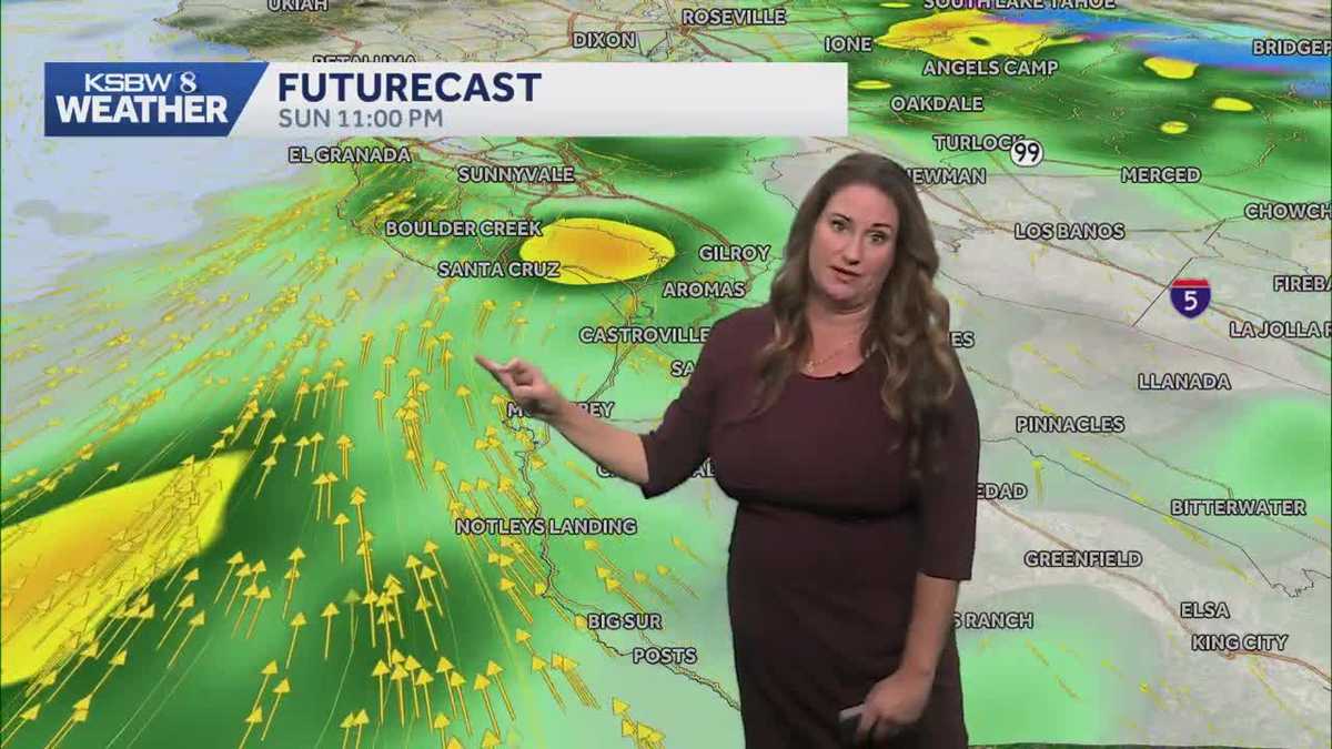
Impact Days are in effect from Sunday through Friday as a multi-storm pattern lines up for the Central Coast, with the Santa Cruz Mountains expected to see impacts as early as Saturday due to a steady, rainy day.
An atmospheric river is expected to impact California late Saturday night through Monday, delivering a concentrated plume of Pacific moisture capable of producing significant rainfall. Forecast guidance suggests the heaviest totals may “park” north of the Bay Area, with parts of Northern California—especially areas north of San Francisco—potentially seeing more than 6 inches of rain.
Locally, totals with the first storm system are projected in the 1–4 inch range. Where rainfall lands within that range will play a major role in determining how much flooding and how many power disruptions develop as additional storms arrive midweek.
A brief lull is possible Monday afternoon into Tuesday, but a second, potentially more impactful system is expected to arrive Tuesday night and continue through Christmas Eve and Christmas Day, with unsettled weather possibly lingering into Friday.
Impact Day vs. Alert Day
Wednesday and Thursday (Christmas Eve and Christmas) may be upgraded to an “Alert Day,” depending on how much rain falls through Monday.
An “Impact Day” indicates weather may disrupt plans with nuisance-level issues, while an “Alert Day” is reserved for the potential of dangerous, life-threatening conditions.
For this event, the primary threats would be flooding on roads and in typical low-lying trouble spots, rapid rises in streams and creeks, and hazards from downed trees and power outages.
Why Major River Flooding Isn’t the Main Concern
Despite the wet outlook, major river flooding is not currently expected locally because major rivers are running very low. In addition, the absence of recent local burn scars reduces the likelihood of large debris flows.
However, rockfalls and minor mudslides remain possible in mountain communities and along steep roadways—especially as soils become increasingly saturated.
Wind Adds to Power Outage Risk
Wind is expected to increase midweek, and with waterlogged ground, trees may be more prone to falling. Power outages are considered likely across the Central Coast as the second system moves in.
Wind advisories may be issued as early as Monday for the midweek period, and forecasters say Sunday night into Monday is the likely window for determining whether Alert Days will be posted for the holiday storm.
Residents are urged to monitor updated forecasts, plan for travel delays during the holiday period, and prepare for possible outages—especially in areas prone to flooding, falling trees, or poor drainage.