
Northern California forecast: Sunday and Monday are Impact Days for rainy and breezy conditions
An atmospheric river takes aim at Northern California, delivering a rainy and windy holiday week.
BUT WHAT ABOUT THE RAIN? THE RAIN IS COMING IN SOME SPOTS TO OUR NORTH. ALREADY SEEING IT, BUT IT IS GOING TO START OFF AS A RAIN EVENT, AND IT WILL TURN INTO A SNOWIER EVENT FOR THE SIERRA LATER ON IN THE WEEK. SO WE’RE BEING EASED INTO THIS STRETCH OF STORMY WEATHER, STARTING WITH SHOWERS ARRIVING TONIGHT. IT HAS BEEN PRETTY STEADY IN THE WEST SLOPE TO SACRAMENTO’S NORTH, AND THAT SNOW LEVEL STARTING PRETTY HIGH ABOVE 8500FT. NOW WE HAVE IMPACT DAYS TOMORROW AND MONDAY AS THE BREEZES NOW PICK UP. AND THEN THE RAIN ALSO PICKS UP AS WELL. WE HAVE SOME POCKETS OF HEAVIER RAIN THROUGH TOMORROW AFTERNOON, AND THAT SNOW LEVEL DOES DROP A LITTLE BIT TO 7000FT. THAT’S PASSED LEVEL NOW. TUESDAY NIGHT THROUGH THURSDAY WE HAVE SOME ALERT DAYS THAT KICK IN AND WE DON’T ISSUE TOO MANY OF THESE. WE’RE TALKING HEAVY RAIN AND GUSTY WINDS WITH HEAVY SNOW. THAT SNOW LEVEL NOW DROPPING TO 5500FT. RIGHT NOW MOST OF THE CITY OF SACRAMENTO SOUTH STILL DRY, BUT THE SHOWERS ARE COMING AND THEY’RE PRETTY SPOTTY AS YOU CAN TELL RIGHT NOW. THAT LINE OF SHOWERS MOVING PAST YUBA CITY DOWN SOUTH. BUT WE STILL HAVE SOME SHOWERS THROUGH GRASS VALLEY TURNING INTO SOME POCKETS OF LIGHT TO MODERATE RAIN SHOWERS AS IT APPROACHES THE CREST. AND WE EVEN HAVE SOME MIXED PRECIPITATION IN THE VERY PEAK SOUTH OF LAKE TAHOE. MUCH MORE OF IT WHERE IT’S COMING FROM. NOWHERE DONE WITH THIS STRETCH OF STORMY WEATHER. YET AS THIS MOISTURE CONTINUES TO TRAIN IN FROM HAWAII. THIS IS AN ATMOSPHERIC RIVER. IMAGINE IT LIKE A LOOSE FIRE HOSE, RIGHT? HOW IT SWINGS BACK AND FORTH WHEN IT’S ON FULL BLAST IS REALLY GOING TO DETERMINE HOW MUCH RAIN WE’RE GETTING AND AT WHAT TIME. SO FROM SUNDAY TO MONDAY, WE’RE EXPECTING SOME SPOTTY RAIN SHOWERS AND ALSO SOME PERIODS OF HEAVY RAIN AND SOME BREEZES. HOWEVER, AS THIS FIRE HOSE LIFTS UP AND WINDS BACK ON TUESDAY, WE’RE EXPECTING A DRIER TUESDAY AND SOME WINDS DON’T BE FOOLED BECAUSE THEN THAT FIRE HOSE SWINGS RIGHT INTO THE REGION AND WE’RE GETTING SOME HEAVY RAIN ON WEDNESDAY WITH SOME MOUNTAIN SNOW. NOW THAT ATMOSPHERIC RIVER DOES SHIFT OFF TO THE EAST, BUT RIGHT BEHIND IT WE HAVE A COLD FRONT. AND AS WE TRANSITION FROM ONE TO ANOTHER, THE WINDIEST HOURS WILL BE WEDNESDAY NIGHT GOING INTO CHRISTMAS MORNING, THAT COLD FRONT PASSES ON CHRISTMAS DAY ITSELF, AND IT’S ACTUALLY BEING DELIVERED BY THE COLD CORE LOW THAT WILL BE DROPPING OUT OF THE GULF OF ALASKA. SO SOME VERY COLD AIR THAT WILL BE MOVING IN JUST IN TIME FOR CHRISTMAS. AND THAT’S WHAT WILL REALLY DROP THOSE SNOW LEVELS LIKE A ROCK. SO WEDNESDAY AND THURSDAY, AS THOSE TWO WEATHER SYSTEMS MOVE THROUGH, THOSE ARE GOING TO BE ALERT DAYS. RAIN IS GOING TO BE HEAVY AT TIMES. MINOR FLOODING AND STREETS AND CREEKS. THAT’S WHEN WE’LL BE WATCHING OUT FOR THE UNREGULATED RIVERS LIKE THE COSUMNES FOR SOME FLOODING. AND THE WINDS MAY AT TIMES BE DAMAGING, WITH GUSTS IN THE VALLEY 40 TO 50MPH, AND THAT SNOW LEVEL WILL DROP TO 5500FT. HOW MUCH RAIN ARE WE LOOKING AT FROM NOW UNTIL NEXT FRIDAY? ANYWHERE UP TO A HALF INCH HALF FOOT HERE IN SACRAMENTO AND YUBA CITY. SMALLER AMOUNTS IN STOCKTON MODESTO. STILL SUBSTANTIAL AND SIGNIFICANT THERE, LOOKING AT 2 TO 5IN, BUT THE HEAVIEST RAIN WILL BE IN THE FOOTHILLS UP TO A FOOT, IF NOT MORE OF RAIN AND PLACERVILLE AND BLUE CANYON. IF YOU’RE GOING TO WANT TO NARROW THE FORECAST DOWN TO CHRISTMAS DAY. JUST DOWNRIGHT COLD, WINDY AND RAINY. AND ON CHRISTMAS DAY ITSELF, WE’RE LOOKING AT ONE TO 1.5IN OF RAIN WITH POSSIBLE 1 TO 2FT OF SIERRA SNOW. SEVEN DAY FORECAST. A LOT TO STOMACH HERE IN THE FOOTHILLS. THAT WILL BE THE RAINIEST REGION. TEMPERATURES, THOUGH, DON’T SHIFT WAY TOO MUCH. THEY DROP BACK DOWN TO HIGHS OF 40S. BUT IN THE FOOTHILLS, YOU’RE GOING TO WANT TO WATCH OUT FOR STORM IMPACTS PRETTY MUCH EVERY DAY. FOR WITH THE STORMIEST DAYS ON WEDNESDAY AND THURSDAY IN THE SIERRA, IT WILL GRADUALLY GET SNOWIER AND SNOWIER AS SNOW LEVELS EVENTUALLY DROP, BOTTOMING OUT AT 4000FT IN ELEVATION ON FRIDAY. AND HERE IN THE VALLEY WE HAVE RAIN AND WIND PRETTY MUCH EVERY DAY, WITH THE MOST IMPACTFUL DAYS ON CHRISTMAS EVE AND CHRISTMAS DAY ITSELF. THE MESSAGING JUST BE BE PREPARED FOR SOME STORMY WEATHER, ESPECIALLY IF YOU’RE GOING TO BE TRAVELING. YOU’LL WANT TO PLAN AHEAD AND KNOW T
Northern California forecast: Sunday and Monday are Impact Days for rainy and breezy conditions
An atmospheric river takes aim at Northern California, delivering a rainy and windy holiday week.

Updated: 8:57 PM PST Dec 20, 2025
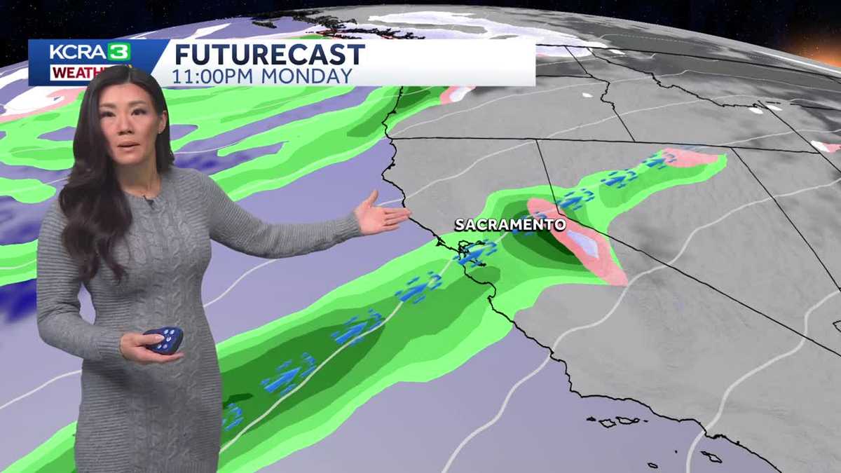
An atmospheric river takes aim at Northern California, delivering a rainy and windy holiday week.Spotty rain showers will intensify through Sunday, becoming heavy at times during the afternoon and evening. Sunday will also be breezy in the Valley and windy in the Sierra.As this round of showers moves into the foothills on Monday, rain will taper in the Valley but remain moderate to heavy in the foothills and Sierra. Winds will be light on Monday.The band of rain shifts north on Tuesday. There will be a break from heavy rain in the morning and afternoon, but winds will return, strengthening by evening with gusts near 40 mph in the Valley and stronger winds in the foothills and Sierra. Snow levels will drop to 7,000 feet.Rain picks up again Tuesday evening as the atmospheric river pushes west to east across the region. Tuesday night will be rainy and windy.There is another lull in stormy weather Wednesday morning and afternoon, but another round of strong winds and heavy rain will move through Wednesday night into Christmas Day as a cold front swings in.This cold front is associated with a cold core dropping out of the Gulf of Alaska and will lower snow levels in the Sierra to 5,500 feet, bringing the heaviest snowfall of the week.The rest of Christmas Day will be windy with light to moderate rain showers. Breezes and showers will linger Friday, and snow will continue to fall in the Sierra as snow levels drop to near 4,500 feet.
SACRAMENTO, Calif. —
An atmospheric river takes aim at Northern California, delivering a rainy and windy holiday week.
Spotty rain showers will intensify through Sunday, becoming heavy at times during the afternoon and evening. Sunday will also be breezy in the Valley and windy in the Sierra.
As this round of showers moves into the foothills on Monday, rain will taper in the Valley but remain moderate to heavy in the foothills and Sierra. Winds will be light on Monday.
The band of rain shifts north on Tuesday. There will be a break from heavy rain in the morning and afternoon, but winds will return, strengthening by evening with gusts near 40 mph in the Valley and stronger winds in the foothills and Sierra. Snow levels will drop to 7,000 feet.
Rain picks up again Tuesday evening as the atmospheric river pushes west to east across the region. Tuesday night will be rainy and windy.
There is another lull in stormy weather Wednesday morning and afternoon, but another round of strong winds and heavy rain will move through Wednesday night into Christmas Day as a cold front swings in.
This cold front is associated with a cold core dropping out of the Gulf of Alaska and will lower snow levels in the Sierra to 5,500 feet, bringing the heaviest snowfall of the week.
The rest of Christmas Day will be windy with light to moderate rain showers. Breezes and showers will linger Friday, and snow will continue to fall in the Sierra as snow levels drop to near 4,500 feet.