
IMPACT DAY: Heavy rain and gusty winds in Northern California
Heavy rain and breezy conditions are expected today with the heaviest rain expected in the Foothills and the strongest winds in the Sierra. More active weather is forecast over the coming days.

Updated: 7:24 AM PST Dec 21, 2025
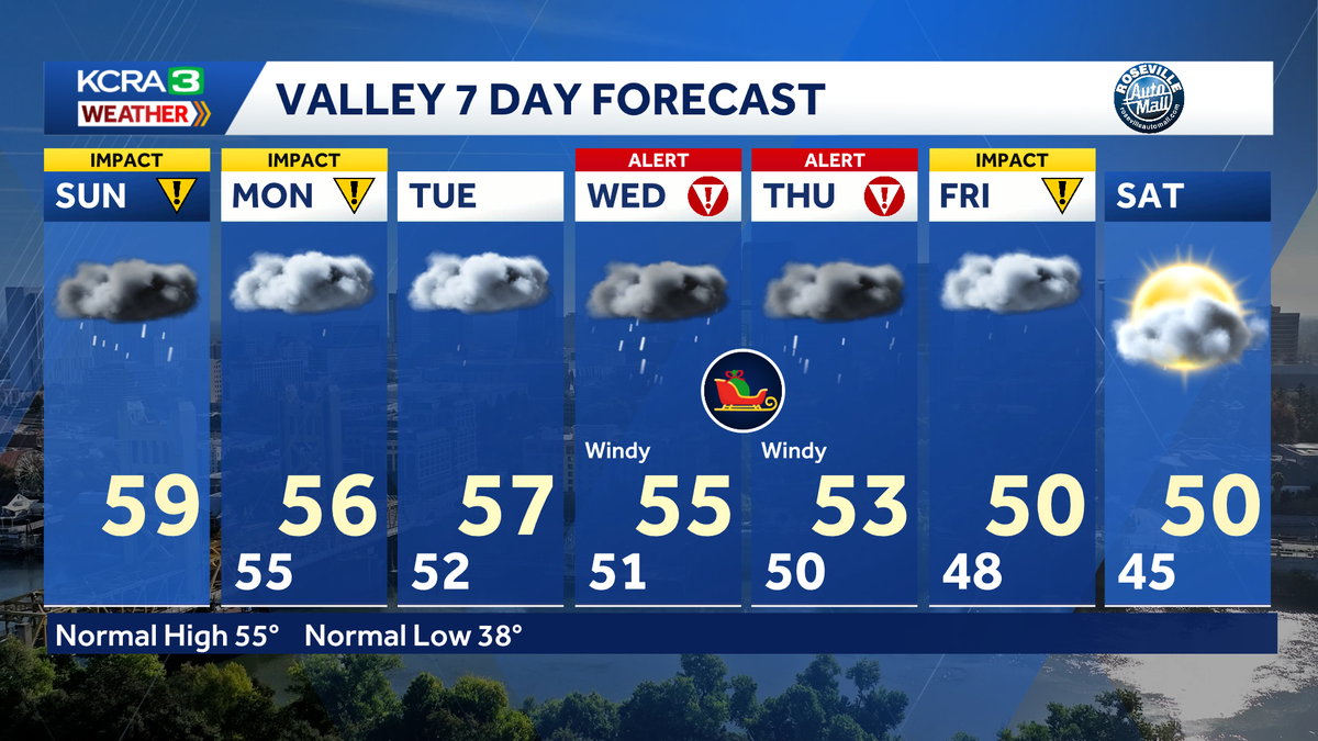
Sunday and Monday are IMPACT DAYS across Northern California.Rain will be heavy at times today and tomorrow with the heaviest expected in the Foothills and Sierra. Breezy conditions are also expected with SW gusts 35-40 mph in the Valley and Foothills. Stronger winds are forecast for the Sierra where a Wind Advisory is in place and gusts to 60 mph are possible. Scattered showers are forecast for Tuesday.Wednesday and Thursday are ALERT DAYS as we expect more heavy rain, windy conditions and snowfall we’ll be measuring in feet! Travel will be difficult, especially through the Sierra. Valley rain and Sierra snow lingering into Friday. By the time it’s all said and done, portions of the Valley could see up to 6″ of rain and parts of the foothills could see rainfall totals up to 15″. Donner Summit could see 4-6 feet of snow, and Sonora Pass could see up to 10 feet. Sunday is also the WINTER SOLSTICE… the longest night and the astronomical start to winter. The Solstice occurs at 7:03 am PSTREAL-TIME TRAFFIC MAPClick here to see our interactive traffic map.TRACK INTERACTIVE, DOPPLER RADARClick here to see our interactive radar.DOWNLOAD OUR APP FOR THE LATESTHere is where you can download our app.See more coverage of top California stories here | Download our app | Subscribe to our morning newsletter | Find us on YouTube here and subscribe to our channel
SACRAMENTO, Calif. —
Sunday and Monday are IMPACT DAYS across Northern California.
Rain will be heavy at times today and tomorrow with the heaviest expected in the Foothills and Sierra. Breezy conditions are also expected with SW gusts 35-40 mph in the Valley and Foothills. Stronger winds are forecast for the Sierra where a Wind Advisory is in place and gusts to 60 mph are possible.
Scattered showers are forecast for Tuesday.
Wednesday and Thursday are ALERT DAYS as we expect more heavy rain, windy conditions and snowfall we’ll be measuring in feet! Travel will be difficult, especially through the Sierra.
Valley rain and Sierra snow lingering into Friday.
By the time it’s all said and done, portions of the Valley could see up to 6″ of rain and parts of the foothills could see rainfall totals up to 15″. Donner Summit could see 4-6 feet of snow, and Sonora Pass could see up to 10 feet.
Sunday is also the WINTER SOLSTICE… the longest night and the astronomical start to winter. The Solstice occurs at 7:03 am PST
REAL-TIME TRAFFIC MAP
Click here to see our interactive traffic map.
TRACK INTERACTIVE, DOPPLER RADAR
Click here to see our interactive radar.
DOWNLOAD OUR APP FOR THE LATEST
Here is where you can download our app.
See more coverage of top California stories here | Download our app | Subscribe to our morning newsletter | Find us on YouTube here and subscribe to our channel