
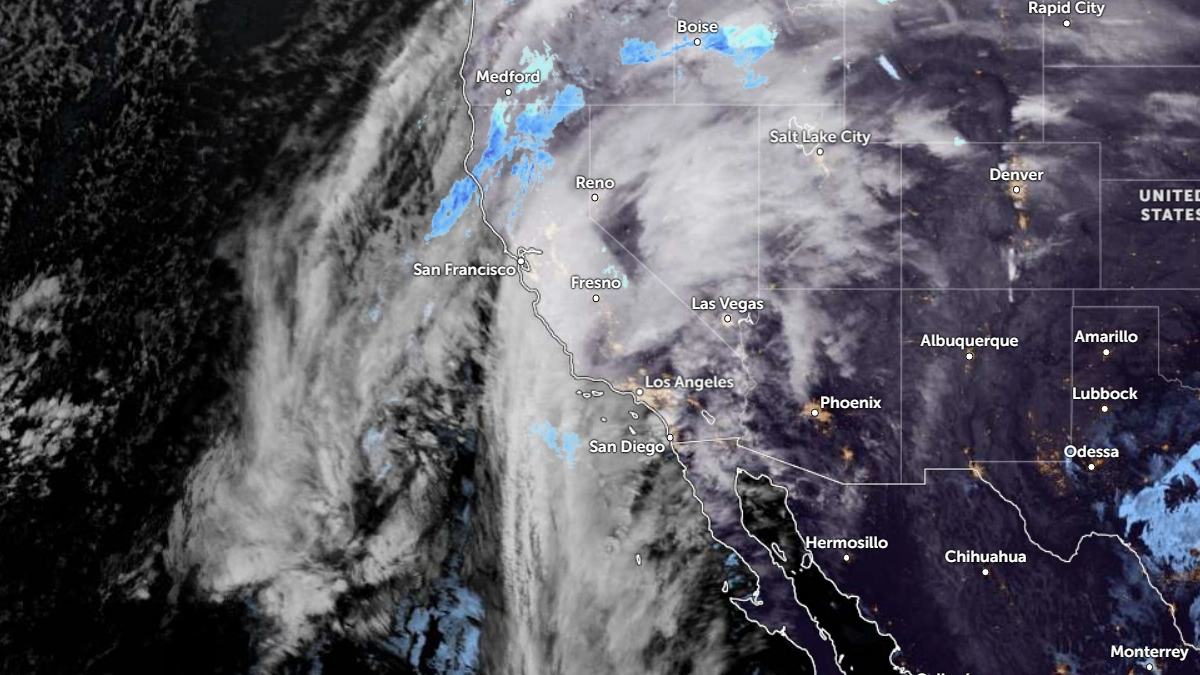
A strong atmospheric river (AR) is forecast to bring heavy rain, mountain snow, and flooding across much of California this week, according to the Center for Western Weather and Water Extremes (CW3E) and the National Weather Service (NWS).
The first AR, which made landfall on December 20, produced 75–250 mm (3–10 inches) of rain across northern California before dissipating on December 22.
A second, stronger AR is expected to move onshore late Tuesday, December 23, followed by another storm system developing on December 24, which will maintain widespread precipitation through December 27.
Video credit: CW3E
Forecast models from CW3E’s West-WRF ensemble indicate the second AR could bring AR4 conditions (on a scale of 1 to 5) in San Diego County, and AR3 intensity along much of the coastal central and southern California.
Probabilities exceed 95% for integrated vapor transport (IVT) values above 250 kg m⁻¹ s⁻¹ along the coast and up to 85% for strong AR conditions within the system’s core.
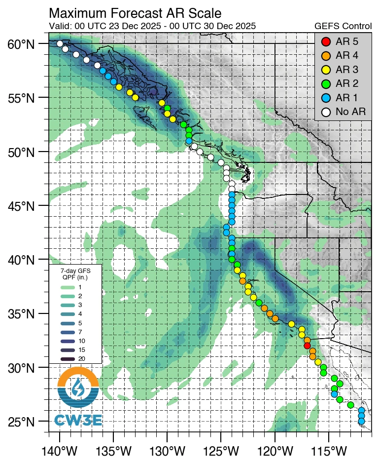 Image credit: CW3E
Heavy precipitation is forecast to focus along the southern slopes of the Transverse Range, including the San Bernardino, San Gabriel, and Sierra Madre Mountains. Rainfall rates there could exceed 12 mm (0.5 inches) per hour, raising a high risk of flash flooding and shallow landslides, particularly near burn scars.
Video credit: CW3E
The Weather Prediction Center (WPC) has issued a high-risk (level 4 of 4) excessive rainfall outlook (ERO) for the Transverse Ranges and a moderate-risk (level 3 of 4) ERO for coastal southern California between December 23 and 25. Slight risk EROs cover much of coastal California, the Sacramento Valley, and the Sierra Nevada foothills.
Snowfall is expected to be significant in the Sierra Nevada, with 60–120 cm (24–48 inches) forecast above 2 400 m (8 000 feet) and localized totals potentially exceeding 180 cm (70 inches) near the crest by December 26. The combination of heavy snow and strong winds will likely produce blizzard conditions and extreme winter storm impacts.
Freezing levels are expected to start above 2 400 m (8 000 feet) but gradually fall below 1 800 m (6 000 feet) during the later phase of the event, expanding snow coverage in the Sierra and reducing flood potential in higher basins.
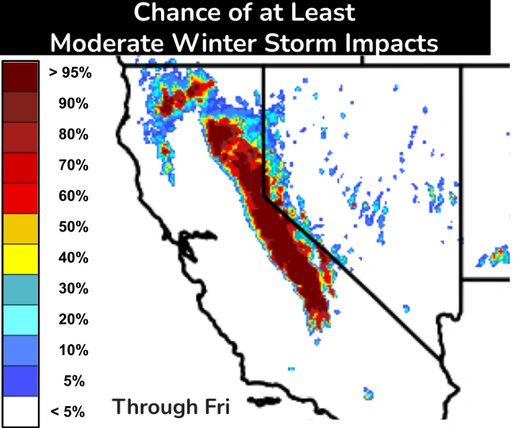 Image credit: NWS/WPC
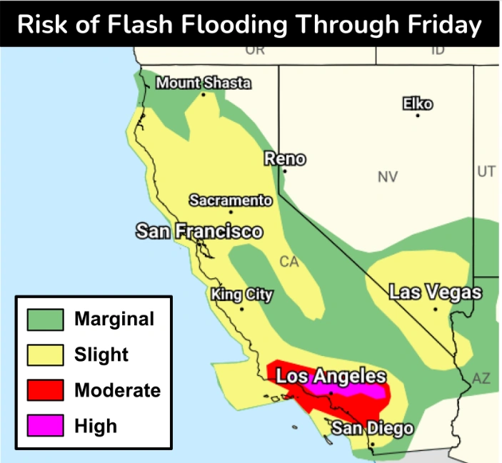 Image credit: NWS/WPC
Hydrologic forecasts from the California-Nevada River Forecast Center (CNRFC) show rivers and streams across the state rising sharply during the second and third AR periods.
Both the Russian River at Hopland and the Sacramento River at Tehama Bridge are forecast to reach flood stage between December 23 and 25, while the San Diego River at Fashion Valley may exceed monitor stage on December 24.
Strong southerly winds are also expected across the coastal and mountainous regions, increasing the risk of downed trees and power outages.
The NWS advises continuous monitoring of local watches and warnings through the week as the atmospheric river system evolves.